Distributed real-time three-dimensional geographic surveying and mapping system on basis of unmanned aerial vehicle clusters

A distributed real-time, unmanned aerial vehicle technology, applied in surveying and navigation, measuring device, photogrammetry/video surveying and other directions, can solve the problem of poor acquisition accuracy, high weather conditions, and limit the efficiency of UAV surveying and mapping. and other problems to achieve the effect of shortening the time

Inactive Publication Date: 2017-07-28
苏州光之翼智能科技有限公司
View PDF4 Cites 6 Cited by
  • Summary
  • Abstract
  • Description
  • Claims
  • Application Information

AI Technical Summary

Problems solved by technology

[0003] The existing three-dimensional geographic information rendering requires professional personnel with low-altitude flight qualifications, aircraft on duty, and data collection through complex recording and camera equipment; the entire process has high requirements for personnel and weather conditions; and due to many Human-computer interaction, many uncertain factors, poor acquisition accuracy, poor real-time; The computing power of the UAV will also limit the efficiency of UAV mapping

Method used


Image

  • Distributed real-time three-dimensional geographic surveying and mapping system on basis of unmanned aerial vehicle clusters
  • Distributed real-time three-dimensional geographic surveying and mapping system on basis of unmanned aerial vehicle clusters

Examples


Embodiment 1

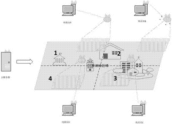
[0055] Such as figure 2 Shown: This set of examples includes a main server, a cluster of 4 drones, and 4 corresponding to the ground station host.

[0056] 1) Delineate the boundary of the area to be surveyed and mapped on the plane ground of the main server;

[0057] 2) The main server divides the area to be tested into four areas according to the UAV cluster configuration, and calculates the corresponding boundary information;

[0058] 3) The main server sends the boundary information of the 1 / 2 / 3 / 4 area to the corresponding ground station host A / B / C / D;

[0059] 4) The ground station host uploads the task to the corresponding UAV through the "ground station interactive system";

[0060] 5) The UAV plans the automatic surveying and mapping path according to the area information of the assigned task;

[0061] 6) The UAV flies over the surveying area and hovers at the planned collection point;

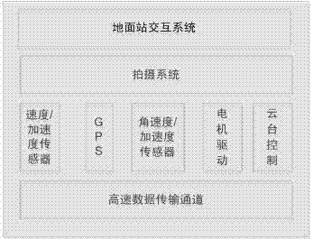
[0062] 7) Adjust the camera pointing through the PTZ, take pictures, and obtai...


PUM


Abstract

The invention discloses a distributed real-time three-dimensional geographic surveying and mapping system on the basis of unmanned aerial vehicle clusters. The distributed real-time three-dimensional geographic surveying and mapping system comprises ground station interaction systems, photographing systems, speed / acceleration sensors, GPS (global positioning systems), angular speed / acceleration sensors, motor drive, pan-tilt control and high-speed data transmission channels. The ground station interaction systems are communicated with ground stations via wireless networks, and data can be transmitted between the ground stations and unmanned aerial vehicles via the high-speed data transmission channels. The distributed real-time three-dimensional geographic surveying and mapping system has the advantages that surveying and mapping modes on the basis of the unmanned aerial vehicle clusters are proposed on the basis of real-time surveying and mapping for surveying and mapping requirements on broad regions and are combined with distributed ground station systems, concurrent real-time reconstruction is carried out, and accordingly the time can be shortened to a great extent; surveying and mapping regions are divided, and accordingly concurrent surveying and mapping can be carried out by the unmanned aerial vehicle clusters; three-dimensional geographic information graphs of the large regions can be computed and constructed by the distributed ground stations by the aid of real-time transmission systems in real time.

Description

technical field [0001] The invention relates to a distributed real-time three-dimensional geographic surveying and mapping system based on drone clusters. Background technique [0002] With the needs of digital city construction, security, and forest fire prevention, it is necessary to construct a three-dimensional geographic information map through aerial photography. Due to the advantages of lightness and flexibility, strong programming ability, and low environmental requirements, UAVs can take off at any time at any time; further with the help of real-time image transmission system, the ground station system can receive images and location information in real time, and dynamically construct geographic information maps. [0003] The existing three-dimensional geographic information rendering requires professional personnel with low-altitude flight qualifications, aircraft on duty, and data collection through complex recording and camera equipment; the entire process has hi...

Claims


Application Information

Patent Timeline
IPC IPC(8): G01C11/00
CPCG01C11/00
Inventor 丁军冯翼王猛
Owner 苏州光之翼智能科技有限公司
Why Eureka
Try Eureka