The application of geographical coordinates in large-scale maps, the method of measurement and the realization of the method map

A technology of large-scale maps and geographic coordinates, which is applied to read the geographic coordinates of target points on large-scale maps. The application of geographic coordinate networks in large-scale maps can solve problems such as error-prone, low efficiency, and cumbersome processes, and reduce Effects of reducing errors, reducing workload, and stimulating learning interest

Active Publication Date: 2020-06-26
中国人民解放军69080部队
View PDF0 Cites 0 Cited by
  • Summary
  • Abstract
  • Description
  • Claims
  • Application Information

AI Technical Summary

Problems solved by technology

It can be seen that the above process is cumbersome, inefficient and error-prone

Method used


Image

  • The application of geographical coordinates in large-scale maps, the method of measurement and the realization of the method map

Examples


example 1

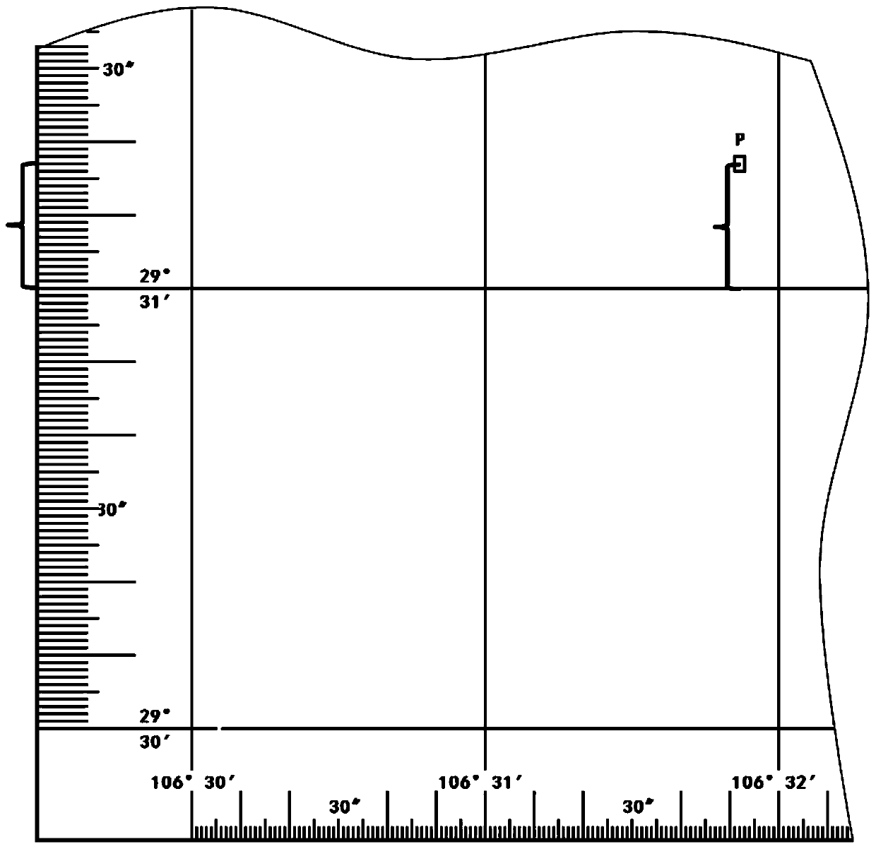
[0036] As shown in the attached figure, the geographic coordinates of the target point P are to be interpreted. Taking the geographic coordinates of point P obtained by the two methods before and after the application of geographic coordinates as an example, the interpretation process and its differences are described in detail.

[0037] The first way: with the original method and map before the use of the present invention, the actual process of measuring the latitude of P point is as follows: the first step, on the graduation band between the west map profiles of the map, pass the map profile southwest corner, northwest Combining the latitude and longitude value difference between the angles and the number of dashes between the Xitu outlines, first determine which group of numbers is the latitude number, and mark the number of points corresponding to the dashes between the degrees. During the operation, because the distance between the dashes and the rectangular coordinates ...


PUM


Abstract

The invention relates to a geographic coordinate in large scale map application and measurement method and a map for implementing the same method. The method of reading the geometric coordinates of the large-scale map comprises the following steps: capturing a vertical distance from the target point to the left longitude or the lower parallel, and reading the geographical coordinates directly on the map edge line near the target point. The large-scale map for implementing the method employs the geometric coordinate network. The indexing zone difference of the adjacent latitude and longitude lines is one point. Each indexing zone is marked with the degree value. Each indexing zone is scaled by second values on the outer edge line. The method process is simplified and the efficiency is high. The line searching error, the line connection error and the reading error of the map user are reduced. The number reading and the formulation calculation are not required, the speed is increased, and the error is reduced. The dependence on the measurement tools such as long rulers and calculators of the personnel is reduced. The map loss is reduced, the manpower and material resources are saved, and wastes of map printing resources are reduced.

Description

technical field [0001] The invention relates to the application of a geographic coordinate network in a large-scale map, specifically including a method for reading the geographic coordinates of a target point on a large-scale map and a map for realizing the method. Background technique [0002] For common maps, the geographic coordinate network adopts the method of Gaussian projection, which is composed of a network of latitude and longitude drawn on a plane. In the second edition of "Military Topography and Orienteering" published by Wuhan University Press in January 2015, it was introduced that on maps with a scale greater than 1:250,000, only the divisions of the graduation bands are drawn between the maps. The corresponding latitude and longitude 1' is divided, and the corresponding latitude and longitude values ​​are marked in the four corners of the figure. When the user needs it, temporarily connect two opposite latitude and longitude dividing short lines, which is ...

Claims


Application Information

Patent Timeline
Patent Type & Authority Patents(China)
IPC IPC(8): G09B29/00
CPCG09B29/006
Inventor 徐云魏敏陶丽郭晓文周鑫林文禄徐卫东金玫王锋陈卫荣马斌刘明涛韩莎莎谢志怀焦艳丽
Owner 中国人民解放军69080部队
Why Eureka
Try Eureka