Improved polarimetric interferometry SAR vegetation height combined inversion method

A joint inversion and height technology, applied in the field of remote sensing image processing, can solve the problem of underestimating the inversion height, and achieve the effect of solving the estimation blur and improving the accuracy.

Inactive Publication Date: 2017-09-08
HARBIN INST OF TECH
View PDF4 Cites 17 Cited by
  • Summary
  • Abstract
  • Description
  • Claims
  • Application Information

AI Technical Summary

Problems solved by technology

[0004] In order to solve the defect of underestimating the retrieval height existing in the existing polarization interference SAR image retrieval method, the present invention provides an improved polarization interference SAR vegetation height joint retrieval method

Method used


Image

  • Improved polarimetric interferometry SAR vegetation height combined inversion method
  • Improved polarimetric interferometry SAR vegetation height combined inversion method
  • Improved polarimetric interferometry SAR vegetation height combined inversion method

Examples


specific Embodiment approach 1

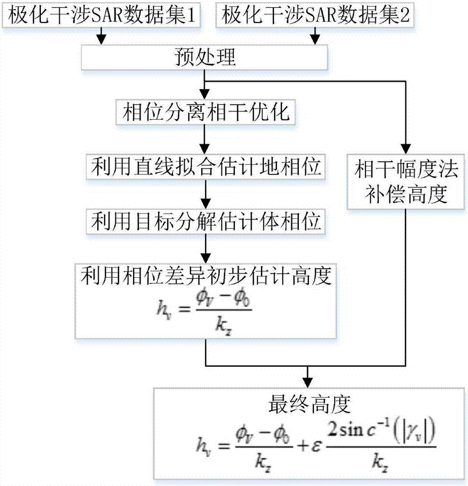
[0023] Specific implementation mode 1: This implementation mode provides an improved polarization interferometric SAR vegetation height joint inversion method, such as figure 1 As shown, the specific implementation steps are as follows:

[0024] Step 1: Input the polarimetric interferometric SAR image, perform preprocessing, and obtain the preprocessed polarimetric interferometric SAR image, where:

[0025] The polarization coherence matrix T of the polarization interferometric SAR image after preprocessing 6 for:

[0026]

[0027] in, and For the Pauli basis scattering vector:

[0028]

[0029] In the above formula, each element S iqp (p,q=H,V) represents the complex backscattering coefficient of the target when transmitting with q polarization and receiving with p polarization, which is obtained by the polarization interferometric SAR system. i=1, 2 represent the primary and secondary SAR images obtained by the radar system at slightly different viewing angles,...

specific Embodiment approach 2

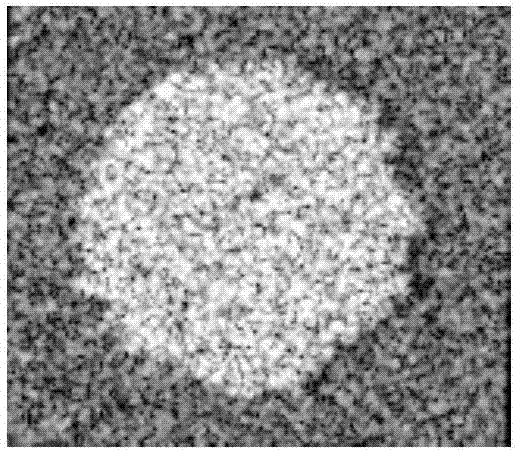
[0076] Specific embodiment two: The experimental image used in this embodiment is the simulated polarization interference SAR image produced by PolSARProSIM software, the image size is 164×141 pixels, and its HH channel amplitude image is as follows figure 2 shown. The tree species in this simulation area is deciduous forest, the forest density is 300 trees / ha, and the average tree height is 10m.

[0077] Using the improved polarization interference SAR vegetation height joint inversion method of the present invention for the polarization interference SAR image, the vegetation height inversion is carried out, and the 3-dimensional imaging results are as follows Figure 4 shown.

[0078] For the 78th column of the image, the height image comparison results of the improved polarization interference SAR vegetation height joint inversion method of the present invention and the three-stage inversion algorithm are as follows Figure 5 shown. For the whole image, the com...


PUM


Abstract

The invention discloses an improved polarimetric interferometry SAR vegetation height combined inversion method. The method includes following steps: step 1, inputting a polarimetric interferometry SAR image, pre-processing the image, and obtaining a preprocessed polarimetric interferometry SAR image; step 2, performing surface phase extraction on the pre-processed polarimetric interferometry SAR image by employing a three-stage algorithm based on phase separation and coherence optimization; step 3, performing polarimetric target decomposition on the pre-processed polarimetric interferometry SAR image based on an Antropov volume scattering model, obtaining a volume scattering component, and extracting a canopy phase; step 4, preliminarily estimating the vegetation height by employing the phase diversity of the surface phase obtained in step 2 and the canopy phase obtained in step 3 according to a phase diversity method; and step 5, compensating the height obtained in step 4 by employing a coherence amplitude method, and realizing the estimation of the vegetation height of the polarimetric interferometry SAR image. According to the method, the problem of fuzzy estimation of the surface phase and the canopy phase is solved, and the inversion precision of the polarimetric interferometry SAR vegetation height is improved.

Description

technical field [0001] The invention belongs to the technical field of remote sensing image processing and relates to an improved joint inversion method of polarization interference SAR vegetation height. Background technique [0002] As an advanced microwave remote sensing method, synthetic aperture radar (SAR) has the advantages of all-weather, all-time, high resolution, and large-area coverage. Polarimetric SAR and interferometric SAR are important branches of traditional SAR systems. Polarization SAR can reflect the backscattering characteristics of the target more systematically and comprehensively by observing the echo information under different transmission and reception polarization combinations, and distinguishing the fine structure of the object, the target orientation and material composition, so as to obtain rich and comprehensive ground object information . Interferometric SAR images the target through two points with slightly different spatial positions, and...

Claims


Application Information

Patent Timeline
Patent Type & Authority Applications(China)
IPC IPC(8): G01S13/90
CPCG01S13/9023
Inventor 张腊梅段宝龙王骁邹斌
Owner HARBIN INST OF TECH
Why Eureka
Try Eureka