Road width estimation method based on high-resolution satellite image

A high-resolution, satellite imagery technology, used in remote sensing applications, to solve problems such as rare research results

Active Publication Date: 2017-09-26
XIAMEN UNIV
View PDF3 Cites 7 Cited by
  • Summary
  • Abstract
  • Description
  • Claims
  • Application Information

AI Technical Summary

Problems solved by technology

However, for road width estimation, th

Method used


Image

  • Road width estimation method based on high-resolution satellite image
  • Road width estimation method based on high-resolution satellite image
  • Road width estimation method based on high-resolution satellite image

Examples


Embodiment Construction

[0028] In order to make the object, technical solution and advantages of the present invention more clear, the present invention will be further described in detail below in conjunction with the accompanying drawings and embodiments. It should be understood that the specific embodiments described here are only used to explain the present invention, not to limit the present invention.

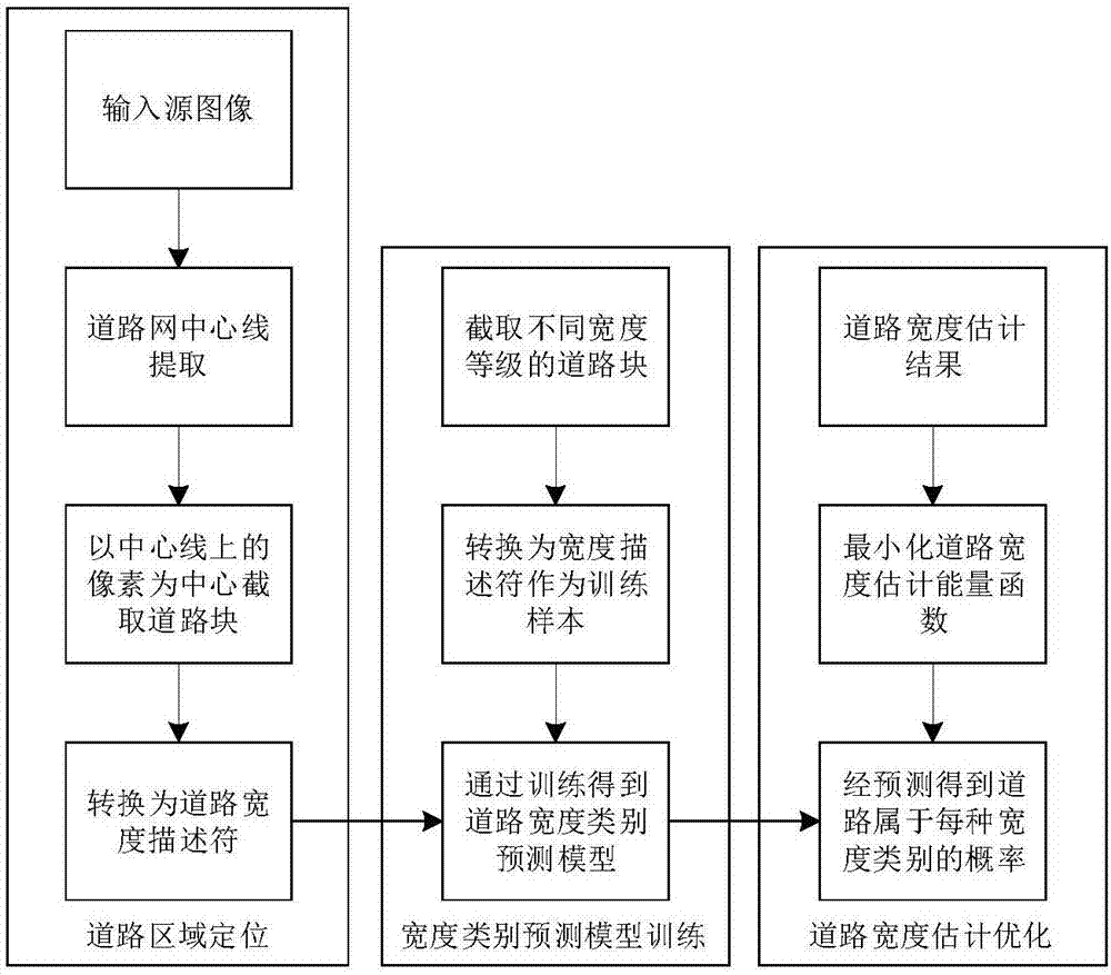
[0029] Such as figure 1 Shown is flow chart of the present invention, mainly comprises following three steps:

[0030] S1. Intercept road block samples of different width levels, convert the road block samples into road width descriptors, and use the width descriptors converted from road block samples of different width levels to train a convolutional neural network to obtain a road width category prediction model.

[0031] Specifically:

[0032] S11. Divide the road width in the satellite image into several grades, and for each road width image grade, intercept a large number of road block sa...


PUM


Abstract

The invention discloses a road width estimation method based on a high-resolution satellite image. A novel road width descriptor is defined according to the characteristics of a road in a high-resolution satellite image. The width features of a road can be described by doing statistics of pixel distribution in road blocks of fixed size and representing pixel distribution with a histogram. On the basis of the road width descriptor and a convolutional neural network, a road width estimation method based on a convolutional neural network is presented. In view of width discontinuity in the road width estimation result, a road width estimation energy function based on space consistency is defined according to the continuity of road width. The category of road width in a satellite image can be estimated reasonably by minimizing the energy function.

Description

technical field [0001] The invention relates to the field of remote sensing applications, in particular to a method for estimating road width based on high-resolution satellite images. Background technique [0002] Satellite remote sensing technology has the characteristics of high efficiency, real-time and information diversification. As an advanced method of earth observation, it plays an important role in the field of urban transportation. Moreover, with the development of remote sensing technology, the resolution has been greatly improved, so that satellite images can express the characteristics of ground objects more clearly, and provide necessary conditions for computers to extract road information from satellite images. Image-based road width estimation is now possible. [0003] Since the 1970s, many scholars have carried out a lot of research work in the field of road information extraction and achieved fruitful results, especially for the extraction of current road...

Claims


Application Information

Patent Timeline
IPC IPC(8): G06K9/00G06K9/46G06K9/62
CPCG06V20/182G06V10/44G06F18/214
Inventor 臧彧王程夏智超栗佩康李军
Owner XIAMEN UNIV
Why Eureka
Try Eureka