Method for vectorization of reservoir geological section map

A geological section and vectorization technology, which is applied in image enhancement, image analysis, image data processing, etc., can solve problems such as unsatisfactory vectorization of stratigraphic section maps and loss of contour information

Inactive Publication Date: 2017-10-20
CHINA UNIV OF PETROLEUM (EAST CHINA)
View PDF6 Cites 16 Cited by
  • Summary
  • Abstract
  • Description
  • Claims
  • Application Information

AI Technical Summary

Problems solved by technology

This method can quickly analyze the drawing and complete the conversion process of the entire vector drawing, but the contour information of the image with a lot of noise is lost.
The above methods have been applied in practical problem solv

Method used


Image

  • Method for vectorization of reservoir geological section map
  • Method for vectorization of reservoir geological section map
  • Method for vectorization of reservoir geological section map

Examples


Embodiment Construction

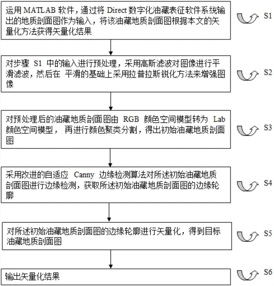
[0032] Attached below Figure 1-5 , use MATLAB software, the present invention is further described: a kind of vectorization method that adopts improved self-adaptive Canny edge detection algorithm to vectorize oil reservoir geologic profile, and specific implementation scheme comprises the following steps, and step is as follows figure 1 Shown:

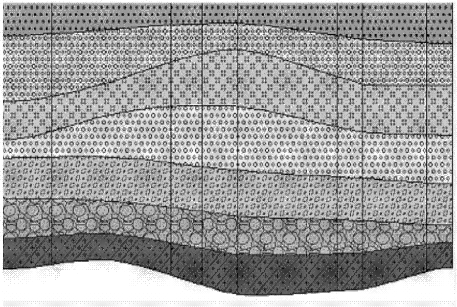
[0033] (1) Bitmap image input. read in MATLAB figure 2 as the initial input;

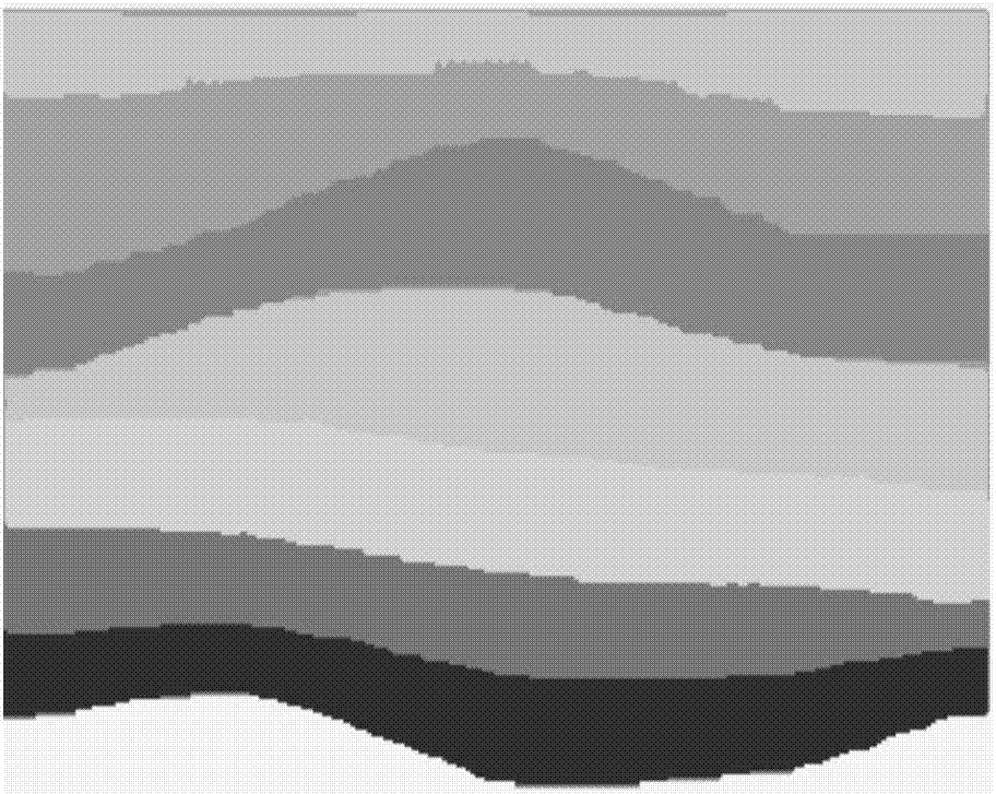
[0034] (2) Image preprocessing. Imported Reservoir Geology Profile figure 2 In addition to the line segments representing stratigraphic boundaries, there are a large number of lithological symbols filled between stratigraphic boundaries, and these lithological symbols have various shapes (such as filling areas, short lines, circles, solid circles, small triangles, etc.) and contain some noise. right figure 2 For preprocessing, first use Gaussian filtering to smooth the image, and then use the Laplacian sharpening method to enhance the image on the...


PUM


Abstract

The invention discloses a novel method for vectorization of a reservoir geological section map. The method is characterized by comprising a step S1 of taking the reservoir geological section map as input; a step S2 of adopting Gaussian filter to perform smoothing filtering on images, and then adopting a laplacian sharpening method to enhance images on a smoothing basis; a step S3 of first performing color space model transformation, and then performing color cluster segmentation; a step S4 of adopting an improved self-adaption Canny edge detection algorithm to perform edge detection on images, and obtaining an edge contour; a step S5 of performing vectorization on the obtained contour; a step S6 of performing vector diagram output: outputting a vector diagram in the SVG format. By use of the vectorization reservoir geological section map, layer information of each layer is retained well, and an obtained vectorization map is easy to edit and store and is well practically applied in geological comprehensive interpretation with drilling.

Description

technical field [0001] The present invention relates to a kind of vectorization method of oil reservoir geologic profile, belongs to the technical field of computer aided design, specifically a kind of multi-level edge based on improved self-adaptive Canny (Canny, John F.Canny developed in 1986) Detection Algorithm) Edge Detection Method for Reservoir Geological Profile Vectorization. Background technique [0002] A geological section map is a map that uses specified symbols, patterns and colors in a certain proportion and along a certain direction to indicate geological phenomena within a certain distance and within a certain depth underground. Generally, stratum structure and rock mass attribute characteristics such as stratum layering, fault and lithology should be expressed. It vividly expresses the structure of the stratum and the sedimentary law of the stratum, and is the most intuitive and effective way of expressing the stratum vertically. Reservoir geological prof...

Claims


Application Information

Patent Timeline
IPC IPC(8): G06F17/50G06K9/62G06T7/13G06T7/136
CPCG06T7/13G06T7/136G06T2207/30184G06T2207/10024G06F30/00G06F18/23213
Inventor 孙歧峰段友祥李洪强李宁宁
Owner CHINA UNIV OF PETROLEUM (EAST CHINA)
Why Eureka
Try Eureka