Coastline extraction method and system based on remote sensing image classification

A remote sensing image and extraction method technology, which is applied in the direction of instruments, character and pattern recognition, scene recognition, etc., can solve the problems of immaturity and inability to accurately correspond to spring tide or high tide water level, etc., and achieve simple scheme, reliable extraction results and high quality requirements low effect

Active Publication Date: 2017-11-17
SHENZHEN INST OF ADVANCED TECH
View PDF7 Cites 9 Cited by
  • Summary
  • Abstract
  • Description
  • Claims
  • Application Information

AI Technical Summary

Problems solved by technology

[0008] To sum up, although remote sensing technology has the advantages of real-time, dynamic, short period, and large range, the existing coastline extraction method based on remote sensing technology only uses the water-land boundary line in the image data as the coastline of the coast, but the actual The situation is that th

Method used


Image

  • Coastline extraction method and system based on remote sensing image classification
  • Coastline extraction method and system based on remote sensing image classification
  • Coastline extraction method and system based on remote sensing image classification

Examples


Embodiment Construction

[0046] In order to make the object, technical solution and advantages of the present invention clearer, the present invention will be further described in detail below in conjunction with the accompanying drawings and embodiments. It should be understood that the specific embodiments described here are only used to explain the present invention, not to limit the present invention.

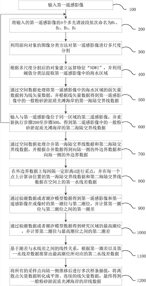
[0047] see figure 1 , is a flowchart of a coastline extraction method based on remote sensing image classification according to an embodiment of the present invention. The coastline extraction method based on remote sensing image classification in the embodiment of the present invention comprises the following steps:

[0048] Step 100: input the first remote sensing image;

[0049] In step 100, the first input remote sensing image is a GF-2 (Gaofen No. 2) remote sensing image. In other embodiments of the present invention, the input remote sensing image may also be other types of remote sensing i...


PUM


Abstract

The invention relates to a coastline extraction method and system based on remote sensing image classification. The method includes the steps of performing multi-scale segmentation on input remote sensing images, and extracting first land-sea boundary line data and second land-sea boundary line data in the remote sensing images to obtain outer boundary data on a landward side; performing sampling on the outer boundary data, and calculating first waterline difference data of the first and second land-sea boundary line data at each sampling point; calculating a first tide level and a second tide level of the two remote sensing images and the highest tide level of a region to be extracted, and calculating a first tide difference between the first tide level and the second tide level and a second tide difference between the second tide level and the highest tide level; and calculating second waterline difference data of the highest tide level based on the first tide difference, the second tide difference and the first waterline difference data, and performing spline interpolation on all the sampling points that are pushed to the landward side according to the second waterline difference data to obtain coastline data of the region to be extracted. According to the invention, the efficiency and precision of the coastline extraction can be effectively improved.

Description

technical field [0001] The invention relates to the technical field of ecological environment monitoring, in particular to a coastline extraction method and system based on remote sensing image classification. Background technique [0002] The coastline is the functional boundary between ocean and land. Among them, the general silt and muddy smooth coastline is an important part of my country's coastline. Generally, the beach surface of silty muddy smooth beach is very gentle, with a slope of only 1 / 1000-1 / 3000. Generally, the intertidal zone of the silt and muddy smooth coast is relatively wide, and obvious tidal grooves can be seen in the intertidal zone. The identification and extraction of the coastline of the general silt and muddy smooth beach is not only a prerequisite for carrying out work such as sea-land coupling, urban expansion, and coastal area development, but also an important topic for research work such as geographic information management and coastal zone...

Claims


Application Information

Patent Timeline
IPC IPC(8): G06K9/00G06K9/34G06K9/62
CPCG06V20/13G06V10/267G06F18/24
Inventor 韩宇陈劲松易琳姜小砾
Owner SHENZHEN INST OF ADVANCED TECH
Why Eureka
Try Eureka