3D high-precision map generation system and method based on vehicle multi-sensor fusion

A multi-sensor fusion and map generation technology, applied in the field of computer vision, can solve problems such as hidden dangers of unmanned vehicles, high cost, and difficulty in achieving high-precision positioning of unmanned vehicles.

Active Publication Date: 2020-05-05
WUHAN UNIV OF TECH
View PDF4 Cites 0 Cited by
  • Summary
  • Abstract
  • Description
  • Claims
  • Application Information

AI Technical Summary

Problems solved by technology

However, the positioning accuracy of traditional maps plus GPS is about 10m, which is difficult to meet the high-precision positioning requirements of unmanned vehicles, which makes unmanned vehicles traveling at high speeds have potential safety hazards
To improve the positioning accuracy, most of the current high-precision positioning systems are expensive. For example, the positioning accuracy of the inertial navigation system (INS) and GNSS integrated navigation system can reach about 20cm, but the cost of the inertial navigation system is about 200,000 yuan. The above is far higher than the most common car cost for the audience

Method used


Image

  • 3D high-precision map generation system and method based on vehicle multi-sensor fusion
  • 3D high-precision map generation system and method based on vehicle multi-sensor fusion
  • 3D high-precision map generation system and method based on vehicle multi-sensor fusion

Examples


Embodiment Construction

[0078] The present invention will be further described below in conjunction with specific examples and accompanying drawings.

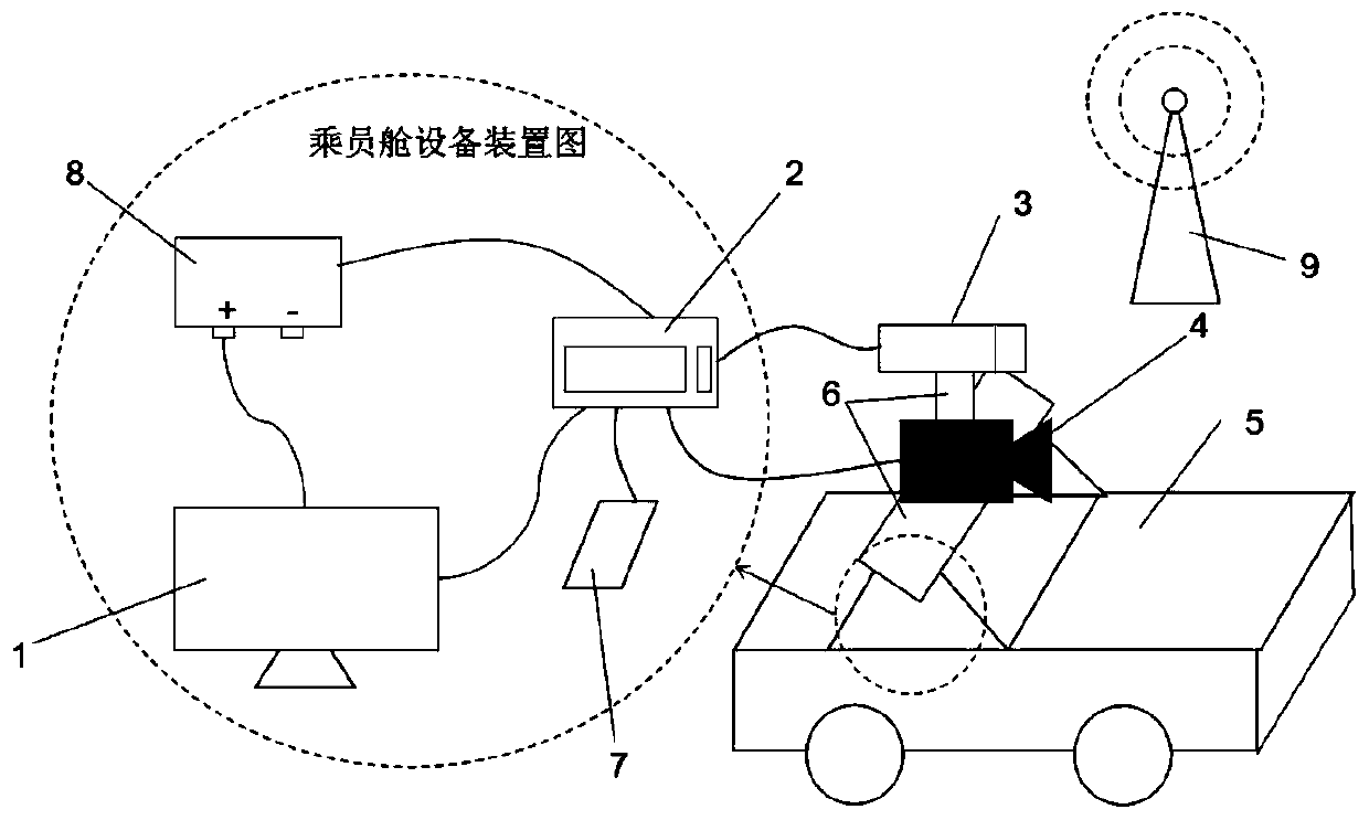
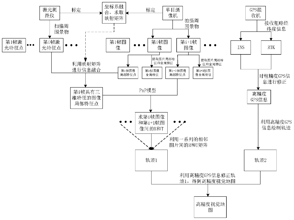
[0079] The present invention provides a three-dimensional high-precision map generation system based on vehicle-mounted multi-sensor fusion, such as figure 1 As shown, it includes: a data acquisition module, including a camera 4, a laser range finder 3, a GPS / INS receiving processor 7 and a differential GPS reference platform 9, the camera 4 is fixed above the vehicle 5, and the laser range finder 3 is fixed on Above the camera 4, the GPS / INS receiving processor 7 is fixed in the car, and the differential PGS reference station 9 is installed at a position where the signal can be received near the acquisition vehicle 5; the data processing module, in this embodiment, is a vehicle-mounted industrial computer, including a vehicle-mounted industrial computer The display 1 and the vehicle-mounted industrial computer host 2 are installed in the vehicle, rec...


PUM


Abstract

The invention provides a system and a method for generating a 3D high-precision map based on vehicular multi-sensor fusion. The system includes a data acquisition module and a data processing module. The data acquisition module includes a camera, a laser range finder, a GPS / INS receiving processor, and a differential GPS reference station. The camera is fixed above a vehicle. The laser range finder is fixed above the camera. The GPS / INS receiving processor is fixed in the vehicle. The differential GPS reference station is installed in a position at which signals can be received near an acquisition vehicle. The data processing module is installed in the vehicle, and is used for receiving data acquired by the data acquisition module and fusing image information and 3D laser information to make a map have image features and 3D features, and combining the image information and 3D laser information with track information composed of high-precision longitude and latitude information and the current position information of the vehicle to construct a 3D high-precision visual map based on multi-sensor fusion. The visual map is the basis for visual positioning, and is an important part for realizing intelligent vehicle environment perception.

Description

technical field [0001] The invention belongs to the field of computer vision, and in particular relates to a three-dimensional high-precision map generation system and method based on vehicle-mounted multi-sensor fusion. Background technique [0002] With the development of intelligent driving, high-precision maps have also received widespread attention. High-precision maps are the basis for autonomous driving. At present, in the field of intelligent transportation, especially in the field of intelligent vehicle unmanned driving, there is a high degree of dependence on high-definition maps, and traditional maps are already full to meet the requirements of intelligent vehicle unmanned driving. With the upsurge of smart car technology research, the problem of creating high-definition maps that can be provided to smart cars has gradually come into people's field of vision. [0003] With the emergence of the geographic information system (GIS), traditional electronic maps stor...

Claims


Application Information

Patent Timeline
Patent Type & Authority Patents(China)
IPC IPC(8): G01S19/47G01C3/02G01S19/13
CPCG01C3/02G01S19/13G01S19/47
Inventor 胡钊政穆孟超李祎承游继安陶倩文黄刚
Owner WUHAN UNIV OF TECH
Why Eureka
Try Eureka