

Unmanned aerial vehicle visual positioning method and device based on airport runway
A technology for visual positioning and airport runways, applied in image analysis, image enhancement, instruments, etc., can solve problems such as increasing equipment cost, GNSS receiver interference, increasing system complexity and cost, and reducing implementation costs and simplifying the system. Effect
Active Publication Date: 2021-08-24
四川腾盾科技有限公司
View PDF23 Cites 0 Cited by
- Summary
- Abstract
- Description
- Claims
- Application Information
AI Technical Summary
Problems solved by technology
[0005] Both microwave beam guidance and differential GNSS require the installation of corresponding special equipment at the airport and on board, increasing the complexity and cost of the system
Microwave beam guidance equipment is expensive, and it is often equipped at relatively high-level airports; differential GNSS equipment is relatively cheap, but it will still increase the cost of equipment, and the communication between differential GNSS and the aircraft and the GNSS receiver on the aircraft are also subject to interference. possibility of
Method used
View moreImage
Smart ImageViewing Examples

Examples
Embodiment 1
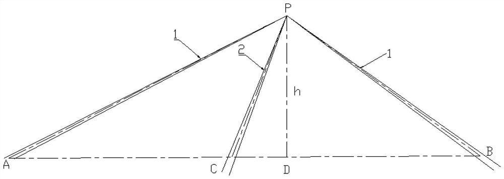
[0064] This embodiment proposes a method for visual positioning of drones based on airport runways, including steps:
[0065] Use the camera unit to obtain runway vision images;
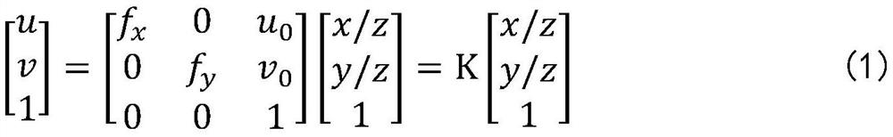
[0066] Establish a mapping relationship between the visual image and the coordinate system of the camera unit;
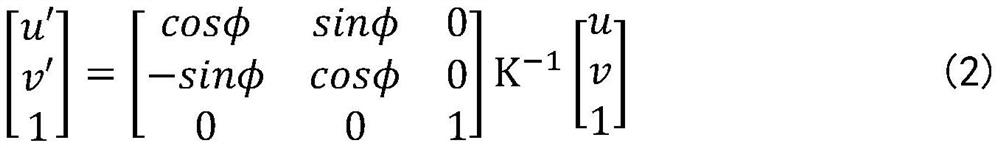
[0067] Obtain the attitude information of the camera unit, then identify the sidelines and centerlines on both sides of the runway in the visual image, and then transform the obtained visual image of the runway according to the attitude information of the camera unit, the mapping relationship between the visual image and the coordinate system of the camera unit, and obtain the Transformed image with optical axis parallel to runway direction;
Login to View More PUM
 Abstract
The invention discloses an unmanned aerial vehicle visual positioning method and device based on an airport runway, and relates to the technical field of aircraft navigation positioning, visual positioning of an unmanned aerial vehicle is realized through runway information and a runway visual image obtained by a camera unit, additional equipment does not need to be added, and no requirement for airport facilities is needed; and the method does not need to depend on an external signal source, avoids external interference, and effectively simplifies the system and reduces the implementation cost compared with a positioning method in a traditional mode.
Description
technical field [0001] The invention relates to the technical field of aircraft navigation and positioning, in particular to a method and device for visual positioning of unmanned aerial vehicles based on airport runways. Background technique [0002] During the landing phase of the aircraft, precise glide trajectory control is required to ensure that the landing point is in a suitable area, which is crucial to the safety of the aircraft's takeoff and landing. If the landing point is too early, the descent height is too fast before entering the runway, and there is a risk of encountering obstacles; if the landing point is too late, the length of the runway will be underutilized, and there is a risk of running out of the runway. When taking off and landing, it is also necessary to keep the aircraft near the centerline of the runway. If it deviates too far, there is a risk of sliding off the runway from the side. [0003] For manned aircraft, the judgment of the position rela...
Claims
Login to View More Application Information
Patent Timeline
 Patent Type & AuthorityApplications(China)
IPC IPC(8): G01C21/20G06T7/73
CPCG01C21/20G06T7/73G06T2207/10016G06T2207/30181
Inventor彭钧刘紫微金曦杨坤王喆徐宇
Owner四川腾盾科技有限公司