Aircraft detection method and height control method

A detection method and technology of flight height, applied in the directions of instruments, measurement devices, radio wave measurement systems, etc., can solve the problem of UAV tilt, inability to accurately detect the accurate distance between UAV and UAV, and the inability of aircraft to predict in advance, etc. question

Inactive Publication Date: 2018-01-05
BENEWAKE BEIJING TECH CO LTD
View PDF5 Cites 3 Cited by
  • Summary
  • Abstract
  • Description
  • Claims
  • Application Information

AI Technical Summary

Problems solved by technology

[0004] However, in the prior art, the lidar can only measure the flight height of the drone at a single point, that is, the lidar can only obtain the distance value of a single point for each ranging
In addition, the UAV has a certain speed during flight, and the usual laser radar can only detect the distance value of a single point in the vertical direction, and cannot detect the ground conditions below the UAV in time. When the drone enters a new terrain and adjusts the flight altitude of the drone, it needs a period of delay...

Method used


Image

  • Aircraft detection method and height control method
  • Aircraft detection method and height control method
  • Aircraft detection method and height control method

Examples


Embodiment Construction

[0025] The embodiment of the application discloses an aircraft detection system and an aircraft detection method. Wherein the aircraft detection system includes an aircraft and a detection device fixed on the aircraft.

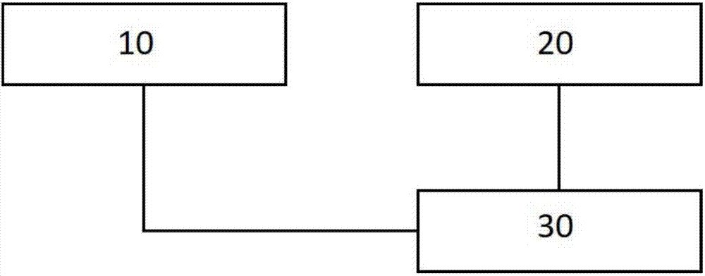
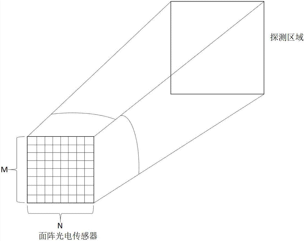
[0026] Detection devices in the aircraft, if attached figure 1 As shown, it includes an infrared light emitting module 10 , a receiving module 20 , and a signal processing and control module 30 . Wherein, the signal processing and control module 30 is connected with the receiving module 20 . Wherein, the receiving module 20 has an area array photoelectric sensor.

[0027] After the detection device receives the work instruction, the infrared light emitting module 10 sends out the infrared detection light modulated by the modulation signal, and the infrared detection light is emitted to the detected area to be detected outside. The infrared detection light is reflected when it encounters an object (obstacle). The receiving module 20 receives the reflected in...


PUM


Abstract

The invention discloses an aircraft detection method. A detection device is arranged in the aircraft, and the detection device detects the distance or the vertical height between the aircraft and a detected area. A planar array photoelectric sensor is arranged in the detection device, the detection device acquires the distance or the vertical height between a below detected area in front of the aircraft and the aircraft based on the planar array photoelectric sensor in a flight state of the aircraft, and the distance between a detected area right below the aircraft and the aircraft can be acquired. The invention also discloses an aircraft height control method. A flight device acquires the vertical height A between a detected area right below the aircraft and the aircraft through the aircraft detection method, the vertical height H1, H2, H3...Hn between the below detected area in front of the aircraft and the aircraft is acquired, and according to the vertical height A and the verticalheight H1, H2, H3...Hn, the flight control system in the aircraft controls the flight height of the aircraft.

Description

technical field [0001] The present application relates to an aircraft detection method and an aircraft altitude control method. Background technique [0002] In the prior art, the UAV needs to measure its height in real time during the working process, and a distance sensor is usually used to collect the height data of the UAV. The distance sensors include devices such as ultrasound, binocular vision, and laser radar. [0003] Among them, in the method of using laser radar, the laser radar is fixed on the UAV. During the working process, the laser radar emitting module emits detection light, and the detection light is emitted to the ground or the surface of other objects to be reflected, forming The echo signal is received by the receiving module of the laser radar. The laser radar calculates the relationship between the UAV itself and the ground according to the time difference, phase difference or triangular position relationship between the detection light sent by the tr...

Claims


Application Information

Patent Timeline
IPC IPC(8): G01S17/08
Inventor 疏达郑凯李远
Owner BENEWAKE BEIJING TECH CO LTD
Why Eureka
Try Eureka