A BRDF data acquisition system and method based on UAV-borne hyperspectral imaging

A data acquisition system and hyperspectral imaging technology, applied in control/adjustment systems, vehicle position/route/altitude control, instruments, etc., can solve the problem of inability to measure large scenes and tall objects, difficult moving process, and difficult operation and other problems, so as to improve the efficiency of flight control, achieve precise control, and reduce the workload of measurement and calculation.

Active Publication Date: 2020-07-24
NINGXIA UNIVERSITY
View PDF12 Cites 0 Cited by
  • Summary
  • Abstract
  • Description
  • Claims
  • Application Information

AI Technical Summary

Problems solved by technology

[0003] The existing ground-based BRDF observation system adopts the way of orbital adjustment of the observation angle, which can realize the collection of BRDF information below 5 meters from the ground, and the moving process is very difficult and difficult to operate as the height increases. Imaging method
[0004] Aiming at the practical problem that the existing ground bidirectional reflectance distribution function (Bidirectional Reflectance Distribution Function, BRDF) measurement system cannot realize the measurement of large scenes and tall ground objects, this application provides a BRDF data acquisition system based on UAV-borne hyperspectral imaging and method

Method used


Image

  • A BRDF data acquisition system and method based on UAV-borne hyperspectral imaging
  • A BRDF data acquisition system and method based on UAV-borne hyperspectral imaging

Examples


Embodiment 1

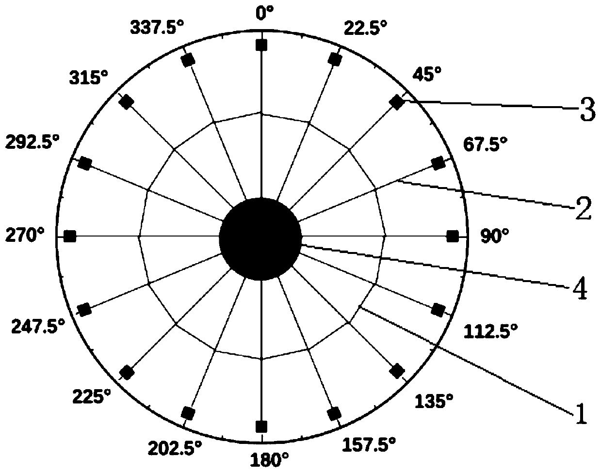
[0044] The present invention provides a BRDF data acquisition system and method based on UAV-borne hyperspectral imaging, specifically as figure 1 As shown, including auxiliary positioning device, data acquisition unit and measurement and control unit;

[0045] The auxiliary positioning device is used to identify the position of the observed ground objects / scenes. The auxiliary positioning device includes a disc 1 engraved with an angle line along the circumference, a plurality of measuring ropes 2 and a plurality of ground marking cloths 3 that cooperate with the measuring ropes 2, The center of the disk 1 is provided with a positioning column 4, and one end of a plurality of measuring ropes 2 is evenly fixed on the positioning column 4 along the circumferential direction, and the positioning column 4 is used to determine the ground starting azimuth corresponding to different solar zenith angles. One end of the measuring rope 2 is fixed at the center of the disc 1, and the gr...


PUM


Abstract

The invention provides a BRDF data acquisition system and method based on unmanned aerial vehicle-mounted hyperspectral imaging, and relates to a data acquisition method which comprises an auxiliary positioning device, a data acquisition unit and a measurement and control unit. The auxiliary positioning device comprises a disc, a measuring rope and ground identification cloth, the data acquisitionunit comprises an unmanned aerial vehicle, a holder and a hyperspectral imager, and the measurement and control unit comprises a graph judgment module, an angle control module, an observation position control module and a data processing module. The collection method comprises the following steps: selecting an observed surface feature / scene, and arranging ground identification cloth; determininga coordinate position W of an observed surface feature / scene center point; calculating an observation angle; determining the hovering position of the unmanned aerial vehicle and collecting data; and forming a BRDF data set based on unmanned aerial vehicle hyperspectral imaging. According to the system, accurate control over the placing position of the ground identification cloth is achieved through the ground angle measuring device, the measuring and calculating workload during each operation is reduced, and the flight control efficiency of the unmanned aerial vehicle is improved.

Description

technical field [0001] The invention relates to a data acquisition method, in particular to a BRDF data acquisition system and method based on unmanned aerial vehicle-borne hyperspectral imaging, which can be applied to research in remote sensing, optics and other fields. Background technique [0002] With the continuous maturity of UAV technology and the convenience of operation, the continuous expansion of application fields, and the integration and innovation with many fields have formed a large number of new ways of thinking and application scenarios. On the other hand, the size and weight of hyperspectral imagers continue to decrease, enabling them to be mounted on unmanned aerial systems for near-surface data collection. With the continuous development of multi-angle remote sensing applications, the demand for basic theoretical research near the surface is increasing. Mounting a hyperspectral imager on a rotary-wing UAV to measure BRDF information near the ground (10-...

Claims


Application Information

Patent Timeline
Patent Type & Authority Patents(China)
IPC IPC(8): G05D1/10G01C11/02
CPCG01C11/025G05D1/101
Inventor 王磊
Owner NINGXIA UNIVERSITY
Why Eureka
Try Eureka