Virtual terrain modeling method based on linear interpolation

A modeling method and linear interpolation technology, applied in the field of computer simulation, can solve the problem of not taking into account speed and accuracy, and achieve the effect of reducing operation time

Inactive Publication Date: 2018-01-05
MAINTENANCE BRANCH COMPANY STATE GRID ZHEJIANG ELECTRIC POWER +2
View PDF1 Cites 5 Cited by
  • Summary
  • Abstract
  • Description
  • Claims
  • Application Information

AI Technical Summary

Problems solved by technology

[0004] At present, in order to increase the speed of virtual terrain generation, the accuracy needs to be sacrificed, and in order to i

Method used


Image

  • Virtual terrain modeling method based on linear interpolation
  • Virtual terrain modeling method based on linear interpolation
  • Virtual terrain modeling method based on linear interpolation

Examples


Embodiment Construction

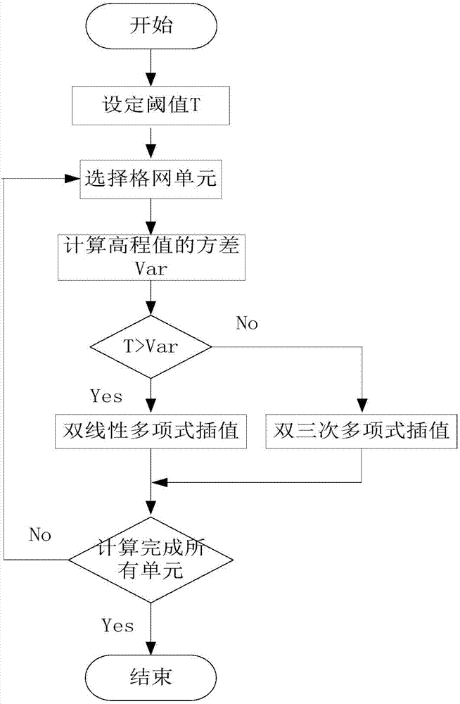
[0029] The technical solution of the present invention will be further described in detail below in conjunction with the accompanying drawings.

[0030] Such as figure 1 Shown, the present invention comprises the following steps:

[0031] 1) Set the threshold T;

[0032] The threshold T is set according to the flatness of the terrain and the requirements of modeling accuracy.

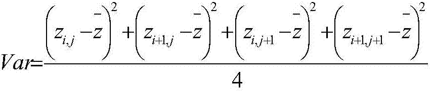
[0033] 2) Select the grid cell and calculate the variance Var of the elevation value;

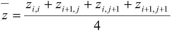
[0034] The area plane is divided into regular grid units, and each unit vertex corresponds to an elevation value. Select one of the units and calculate the variance Var of the elevation value, as shown in formula 1 and formula 2.

[0035]

[0036]

[0037] In the formula: z i,j ,z i+1,j ,z i,j+1 ,z i+1,j+1 is the elevation value of the unit vertex in row i and column j in the regular grid.

[0038] 3) Determine the size of the threshold T and the variance Var, if the threshold is large, go to step 4, o...


PUM


Abstract

The invention discloses a virtual terrain modeling method based on linear interpolation, and relates to the technical field of computer simulation. At present, virtual terrain generation can not be compatible with speed and accuracy. The technical scheme comprises the following steps that: 1) setting a threshold value T; 2) selecting a grid cell, and calculating the variance Var of an elevation value; 3) judging the threshold value T and the variance Var, if the threshold value is large, jumping to 4), and otherwise, jumping to 5); 4) adopting a bilinear polynomial to carry out interpolation calculation, and establishing the terrain structure of a current grid; 5) adopting a bicubic polynomial to carry out terrain interpolation calculation, and establishing the terrain structure of the current grid; and 6) calculating all cells, and finishing terrain modeling based on a regular grid. The technical scheme is compatible with speed and accuracy, the flatness of the grid terrain is judged,different interpolation models are selected, the bilinear polynomial interpolation is adopted in the grid with the flat terrain to guarantee modeling speed, and the simulation accuracy of an area with large terrain fluctuation is improved through the bicubic polynomial.

Description

technical field [0001] The invention relates to the technical field of computer simulation. In particular, it refers to a virtual terrain modeling method based on linear interpolation. Background technique [0002] The digital elevation model (DEM) realizes the simulation of the regional surface topography and geomorphology through the spatial digital coordinates. According to the different data structures, it can be divided into two types: regular grid and irregular triangular network. Among them, the terrain modeling method based on the regular grid divides the regional plane into regular grid units, each unit vertex corresponds to an elevation value, and the elevation value of the point to be fixed is determined by an interpolation function, which has the advantages of small data storage and simple topology , easy to collect and calculate, suitable for modeling large-scale terrain scenes. [0003] Interpolation is an important method for digital elevation models based o...

Claims


Application Information

Patent Timeline
IPC IPC(8): G06T17/05
Inventor 王永虎丁小蔚黄建峰孙福昌覃金彩许杨勇纪日升罗绍青王述汉钟素鹏付军刘红鑫丁健魏文力孙弼洋李博亚丁栩麟吴坤祥郑琪龚坚刚刘燕平周文俊章李刚张盈哲
Owner MAINTENANCE BRANCH COMPANY STATE GRID ZHEJIANG ELECTRIC POWER
Why Eureka
Try Eureka