A Remote Sensing Classification Method for Sea Ice Types

A classification method and type of technology, applied in the field of remote sensing applications, can solve problems such as difficult to achieve large-scale sea ice classification, small space coverage, and limited cost of remote sensing images, so as to achieve simple and easy execution steps, improve classification efficiency, The effect of reducing human involvement

Active Publication Date: 2020-10-09
NANJING UNIV
View PDF7 Cites 0 Cited by
  • Summary
  • Abstract
  • Description
  • Claims
  • Application Information

AI Technical Summary

Problems solved by technology

Early sea ice type data could only be obtained through field surveys. Later, a classification method based on optical and SAR remote sensing images was developed. sea ​​ice classification

Method used


Image

  • A Remote Sensing Classification Method for Sea Ice Types
  • A Remote Sensing Classification Method for Sea Ice Types
  • A Remote Sensing Classification Method for Sea Ice Types

Examples


Embodiment Construction

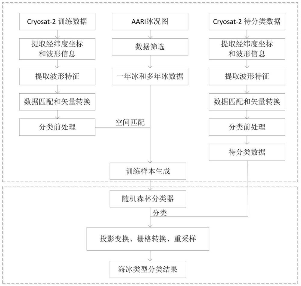
[0040] The present invention will be described in detail below according to the accompanying drawings, so as to make the technical route and operation steps of the present invention clearer. The data used in the examples of the present invention are the CryoSat-2 satellite L1b level SAR model baseline C data and AARIshapfile format data. The training data was obtained from March 1, 2015 to March 30, 2015, the data to be classified was obtained from March 1, 2016 to March 30, 2016, and the AARI data was obtained from March 2016 15th.

[0041] figure 1 It is a flow chart of sea ice remote sensing classification method, and the specific steps are as follows:

[0042] Step 1: Prepare the training data and the data to be classified, and read the information of the data, including the following aspects:

[0043] 1), read the downloaded Cryosat-2 satellite SAR mode L1b level DBL format original file in turn, and obtain the training data (March 1, 2015 - March 30, 2015) and data to...


PUM


Abstract

The invention relates to a remote sensing classification method for sea ice types, which uses satellite radar altimeter Cryosat-2 data to classify polar sea ice, and realizes sea ice classification based on a new method and on a large scale. The steps include obtaining the latitude and longitude coordinates of the measurement point and the corresponding radar echo waveform from the CryoSat-2 altimeter data, extracting the relevant characteristics of the echo waveform; downloading the AARI sea ice type data, and extracting the sea ice type information at the corresponding measurement point ;Perform geographic matching on the above-mentioned extracted data information, and convert it into point data with latitude and longitude coordinates through MATLAB programming; the waveform features at the obtained points and the corresponding sea ice types are used as training data, and the random forest classifier is used for For training, the sea ice classification is carried out on the data to be classified; the classified data are processed in ArcGIS through projection transformation, gridding, etc., and a sea ice type data set with a spatial resolution of 25km is obtained.

Description

technical field [0001] The invention relates to a remote sensing classification method for sea ice types, belonging to the technical field of remote sensing applications. [0002] technical background [0003] The type of sea ice has an important impact on the global climate and is one of the important factors affecting the inversion of sea ice thickness and ship navigation. Early sea ice type data could only be obtained through field surveys. Later, a classification method based on optical and SAR remote sensing images was developed. Scale sea ice classification. With the development of satellite radar altimeters, more scholars have begun to study the use of altimeter data to classify sea ice, because the altimeter has a larger spatial coverage and a higher temporal resolution. Classification of sea ice using altimeters differs from the usual application of altimeter data because altimeters are often used to retrieve sea ice thickness. Since 1990, many scholars have succe...

Claims


Application Information

Patent Timeline
Patent Type & Authority Patents(China)
IPC IPC(8): G06K9/00G06K9/62
CPCG06V20/13G06F2218/10G06F18/24323G06F18/214
Inventor 柯长青沈校熠
Owner NANJING UNIV
Why Eureka
Try Eureka