Quick automatic segmentation method for SAR image coast line based on C-V model of index type multiscale image sequence

A technology of automatic segmentation and image segmentation, applied in image analysis, image enhancement, image data processing and other directions, it can solve the problems of slow iterative time and C-V model cannot be automatically recognized.

Active Publication Date: 2018-03-23
CHINESE ACAD OF SURVEYING & MAPPING
View PDF11 Cites 6 Cited by
  • Summary
  • Abstract
  • Description
  • Claims
  • Application Information

AI Technical Summary

Problems solved by technology

[0008] The purpose of the present invention is to solve the problem that the existing binary multi-scale C-V model cannot automatically identify the coastline and the iteration time is slow, and proposes a fast and automatic segmentation method for the SAR image coastline based on the C-V model of the exponential multi-scale image sequence. According to the fact that electromagnetic waves are absorbed significantly more in water than on land, this method first preprocesses the initial image through horizontal image segmentation processing to determine the initial v

Method used


Image

  • Quick automatic segmentation method for SAR image coast line based on C-V model of index type multiscale image sequence
  • Quick automatic segmentation method for SAR image coast line based on C-V model of index type multiscale image sequence
  • Quick automatic segmentation method for SAR image coast line based on C-V model of index type multiscale image sequence

Examples


Embodiment Construction

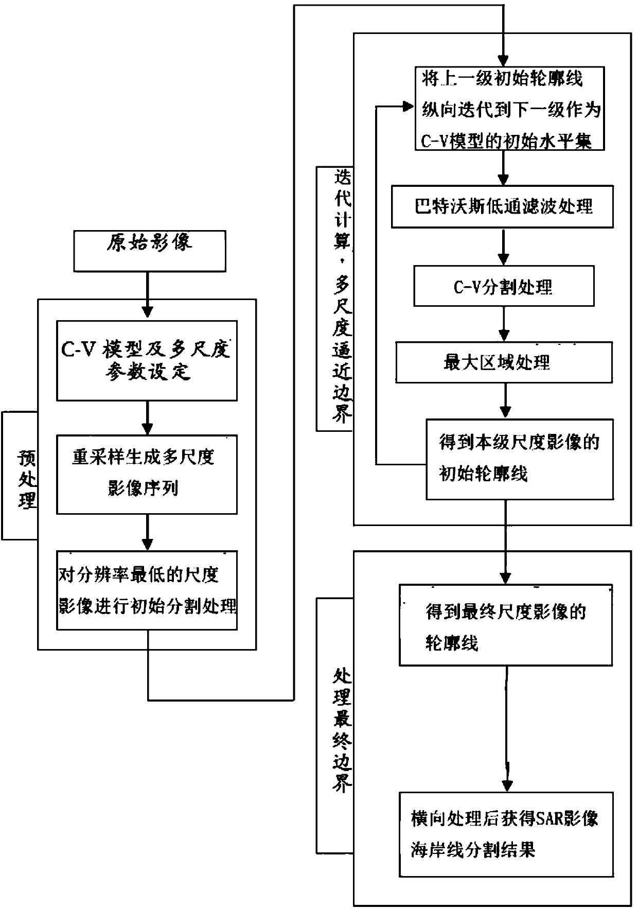
[0073] The present invention will be described in further detail below in conjunction with the accompanying drawings.

[0074] The present invention provides a CV model based on exponential multi-scale image sequence generation method for rapid and automatic segmentation of SAR image coastline. Due to the complexity of the surrounding environment of the coastline, the SAR image has the problem of misclassification of ground objects, so multi-scale and small-scale sampling is adopted the way. Such as figure 1 As shown, the original image is preprocessed first, including the C-V model and multi-scale parameter setting, and the number of applicable iterations is determined according to the complexity of the original image.

[0075] The original SAR image is processed by cubic spline Bessel difference function, and re-sampling is used to generate a multi-scale image sequence with resolution from low to high {V 1 V 2 V 3 ...V i }, (i=1, 2, 3, 4...n; n is the number of multi-scale image...


PUM


Abstract

The invention provides a quick automatic segmentation method for an SAR image coast line based on a C-V model of the index type multiscale image sequence. The method comprises steps that batten Besseldifference function processing of an original SAR image is carried out for three times, a multiscale image sequence with the gradually increasing resolution is generated through re-sampling, transverse image segmentation processing of an upper level image is carried out to acquire a corresponding initial contour of a C-V model, the initial contour is vertically iterated to a lower-level image asan initial level set of the C-V model, a final initial contour is acquired through sequential iteration, the final initial contour is iterated into the original SAR image as an initial level set to carry out transverse image segmentation processing, and the SAR image coast line segmentation result is acquired. The method is advantaged in that on the condition that precision is guaranteed, single iteration approximation coast line calculation amount is smaller than original single iteration calculation amount, the total iteration frequency is reduced, the time efficiency is improved, and rapidcoast line segmentation is realized.

Description

Technical field [0001] The invention belongs to the field of digital image processing of remote sensing images, and particularly relates to a method for fast and automatic segmentation of SAR image coastlines based on a C-V model of exponential multi-scale image sequences. Background technique [0002] The boundary between land and ocean is called coastline. As the boundary between land surface and ocean surface, coastline can be divided into continental coastline and island coastline. Affected by natural and man-made factors, the coastline is constantly changing up and down, which is actually a "belt" called the coastal zone. my country’s coastal zone is the most important economic zone and urban zone in my country. Its safety concerns the survival of the country. It is urgent to increase investment in science and technology. The national coastal zone development and utilization monitoring, as part of the monitoring project of geography and national conditions, plays an importan...

Claims


Application Information

Patent Timeline
IPC IPC(8): G06T7/11G06T7/187
CPCG06T2207/10044G06T2207/30181G06T7/11G06T7/187
Inventor 卢丽君胡娇静张继贤许君一赵争
Owner CHINESE ACAD OF SURVEYING & MAPPING
Why Eureka
Try Eureka