GIS point buffer area analysis method and system

A buffer analysis and buffer analysis technology, applied in the field of GIS, can solve problems such as low efficiency, and achieve the effects of stable analysis process, improved processing performance, and improved efficiency

Inactive Publication Date: 2018-04-10
武汉中地数码科技有限公司 +1
View PDF4 Cites 4 Cited by
  • Summary
  • Abstract
  • Description
  • Claims
  • Application Information

AI Technical Summary

Problems solved by technology

[0008] Therefore, in order to overcome the low efficiency defects of traditional point buffer analysis based on single-th...

Method used


Image

  • GIS point buffer area analysis method and system
  • GIS point buffer area analysis method and system
  • GIS point buffer area analysis method and system

Examples


Embodiment Construction

[0033] The present invention will be further described in detail below through specific embodiments in conjunction with the accompanying drawings.

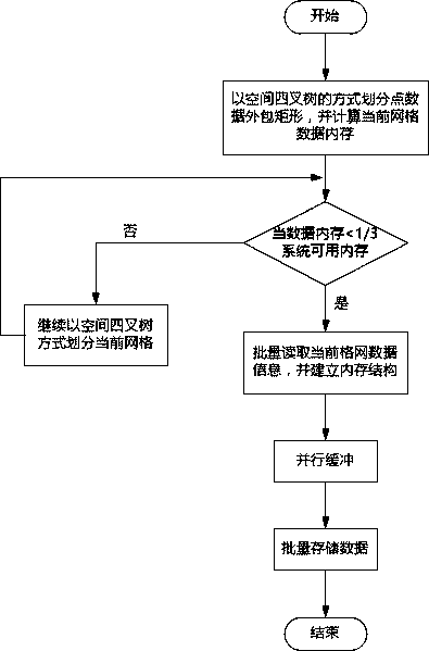
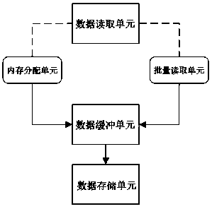
[0034] The embodiment of the present invention provides a kind of GIS point buffer analysis method, it is characterized in that, described method comprises the following steps: A: read the point layer data that will carry out spatial buffer analysis in batches, and establish corresponding memory structure, its The specific steps are: A1: Use the data reading strategy to grid the simple feature class data outsourcing rectangle in the point layer in the form of spatial quadtree;

[0035] The enclosing rectangle is the largest X in the point feature set within the area where the simple feature class data is located max , Y max and minimum X min and Y minThe rectangular area formed by connecting the four points of the grid, the outsourcing rectangle is convenient for the computer to divide the grid; the data reading strategy is to ...


PUM


Abstract

The invention relates to the field of GISs, in particular to a GIS point buffer area analysis method and system. The method and system are characterized in that the method comprises the steps that point map layer data which is about to be subjected to spatial buffer analysis is read in batch, and a corresponding memory structure is built; multi-thread parallel buffer analysis is conducted on all point features read by a system memory; data information of the point features which are subjected to buffer analysis is read and stored in a point simple feature-class map layer of a corresponding database in batch, and then a buffer analysis result is obtained; the system comprises a data read unit, a data buffer unit and a data storage unit. According to the method and system, a multi-thread parallel buffer technology is adopted, and high efficiency and stability of GIS point buffer area analysis are achieved.

Description

technical field [0001] The present invention relates to the field of GIS (Geographical Information System, geographic information system), in particular to a GIS point buffer analysis method and system. Background technique [0002] At present, Geographic Information System (GIS), combining geography and cartography, remote sensing and computer science, has been widely used in different fields to collect, store, manage, retrieve, analyze and describe the whole or part of the earth's surface and spatial geographical distribution data. Spatial information system; among them, spatial analysis is one of the core and key functions of GIS. Spatial analysis is a spatial data analysis technology based on the location and morphological characteristics of geographical objects. Its purpose is to extract and discover hidden spatial information and laws. One of the basic methods of spatial data mining and knowledge discovery. Spatial analysis mainly includes spatial measurement, relation...

Claims


Application Information

Patent Timeline
IPC IPC(8): G06F17/30G06T17/00
CPCG06T17/005G06F16/29
Inventor 吴信才吴亮万波陈波黄胜辉黄波黄颖陈小佩
Owner 武汉中地数码科技有限公司
Why Eureka
Try Eureka