Novel city three-dimensional modeling control system and method

A technology of urban three-dimensional modeling and control system, which is applied in the field of new urban three-dimensional modeling and control system, which can solve the problems of poor building accuracy, poor texture, and no signs on the side of buildings, etc., and achieve the effect of improving work efficiency

Inactive Publication Date: 2018-05-18
HUNAN CITY UNIV
View PDF7 Cites 11 Cited by
  • Summary
  • Abstract
  • Description
  • Claims
  • Application Information

AI Technical Summary

Problems solved by technology

[0003] To sum up, the problems of the existing technology are: since the building occupies a small part in most images, the accuracy of the building becomes poor; the texture of the side of the building is not marked in most cases, and the overall texture poor

Method used


Image

  • Novel city three-dimensional modeling control system and method
  • Novel city three-dimensional modeling control system and method

Examples


Embodiment Construction

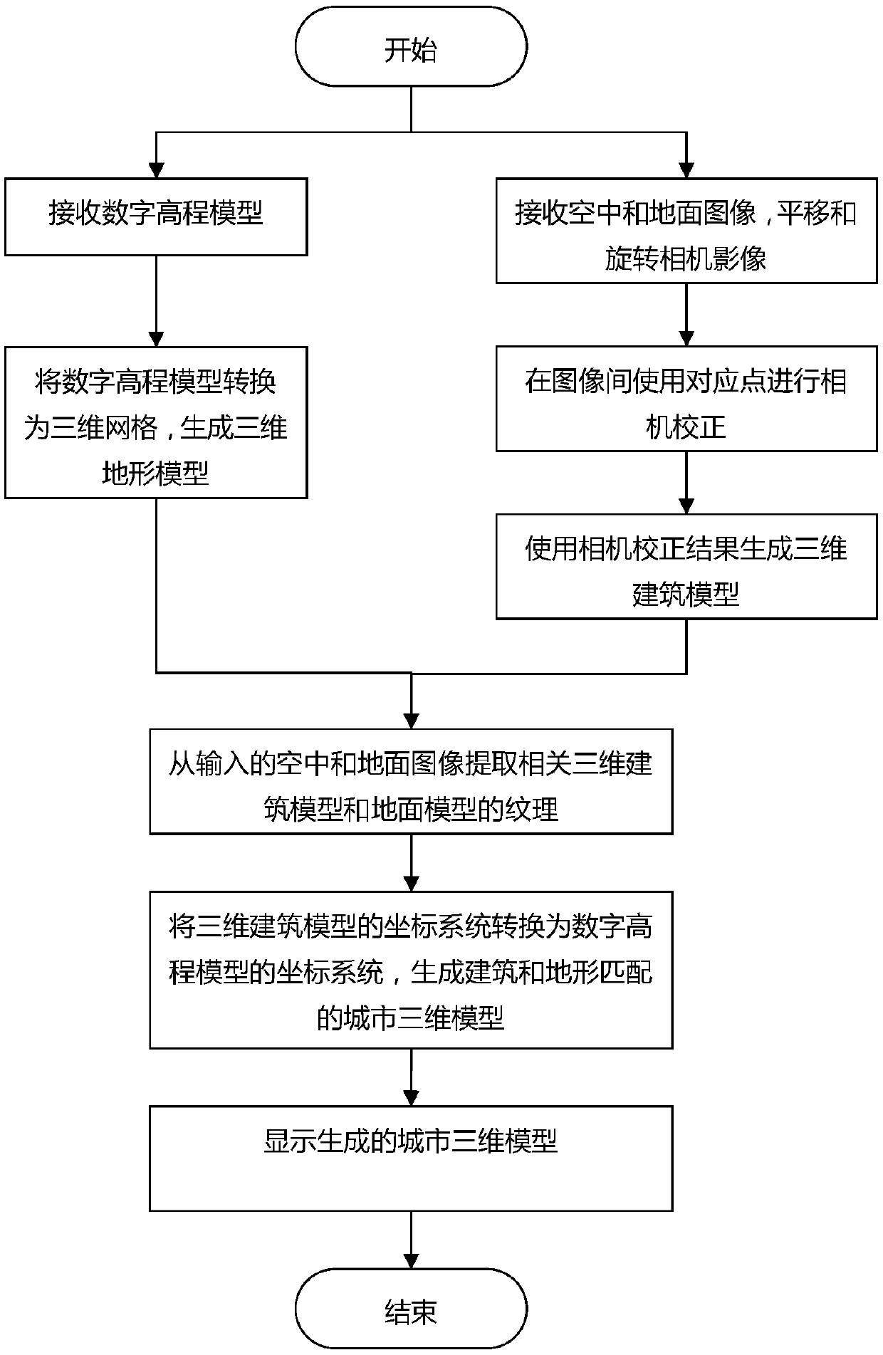
[0030] In order to make the object, technical solution and advantages of the present invention more clear, the present invention will be further described in detail below in conjunction with the examples. It should be understood that the specific embodiments described here are only used to explain the present invention, not to limit the present invention.

[0031] The application principle of the present invention will be described in detail below in conjunction with the accompanying drawings.

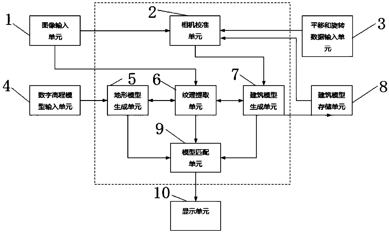
[0032] like figure 1 As shown, the novel urban three-dimensional modeling control system provided by the embodiment of the present invention includes: image input unit 1, camera calibration unit 2, translation and rotation data input unit 3, digital elevation model input unit 4, terrain model generation unit 5, texture An extraction unit 6 , a building model generation unit 7 , a building model storage unit 8 , a model matching unit 9 , and a display unit 10 .

[0033] The image inpu...


PUM


Abstract

The invention belongs to the technical field of three-dimensional modeling, and discloses a novel city three-dimensional modeling control system and method. The system comprises an image input unit, acamera calibration unit, a parallel moving and rotating data input unit, a digital elevation model input unit, a landscape model generation unit, a texture extraction unit, an architectural model generation unit, an architecture model storage unit, a model matching unit and a display unit. According to the system, by using the digital elevation model (DEM) and images acquired from an aerial vehicle and the ground, modeling of three-dimensional appearance of city architectures and three-dimensional landscape is achieved, and realistic textures are extracted from the images; three-dimensional architecture models can be generated by using the images taken from the air in vertical and inclined directions except for the DEM, textures of the related three-dimensional models can be extracted, the three-dimensional models generated by the images acquired from the ground can be simulated more accurately, or the textures with higher definition can be extracted.

Description

technical field [0001] The invention belongs to the technical field of three-dimensional modeling, and in particular relates to a novel urban three-dimensional modeling control system and method. Background technique [0002] Mapping services and ultra-high-speed Internet transmissions using high-resolution satellite imagery have become widely available. In addition, road view or street view type services using images captured on the ground are attracting attention as a new type of service. Map services that use satellite imagery can label buildings or road names on satellite imagery of the area the user expects to see, so it is sometimes possible to search for a route given a source and destination. In addition, map services enable users on the ground to upload images taken in relevant areas to servers, and to view weather and satellite images of the area even with ground images. At the same time, such a map service also enables the sharing of 3D models made by users them...

Claims


Application Information

Patent Timeline
Patent Type & Authority Applications(China)
IPC IPC(8): G06T17/05G06T17/20
CPCG06T17/05G06T17/20G06T2210/04
Inventor 郑卫民谭献良李志学周松林张曦肖敏杨楠陈益平颜紫科罗瑶
Owner HUNAN CITY UNIV
Why Eureka
Try Eureka