Method and device of map software for obtaining pictures, locating information and movement tracks

A technology of moving trajectory and positioning information, applied in the field of positioning display, can solve problems such as increasing the difficulty of identification

Inactive Publication Date: 2018-05-25
刘兴丹
View PDF9 Cites 2 Cited by
  • Summary
  • Abstract
  • Description
  • Claims
  • Application Information

AI Technical Summary

Problems solved by technology

The icon result will increase the difficulty of recognition for the actual scene or people who are not familiar with the map

Method used


Image

  • Method and device of map software for obtaining pictures, locating information and movement tracks
  • Method and device of map software for obtaining pictures, locating information and movement tracks
  • Method and device of map software for obtaining pictures, locating information and movement tracks

Examples


Embodiment Construction

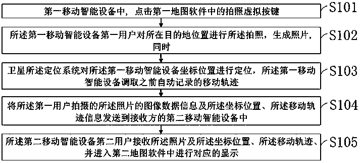
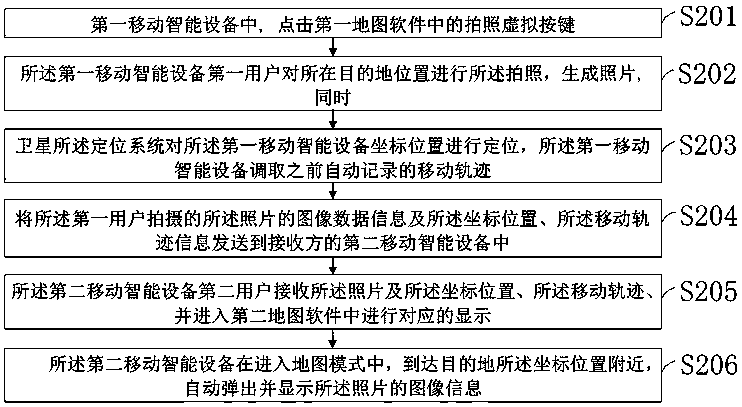
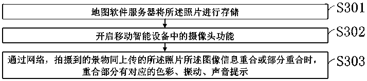
[0046] In order to enable those skilled in the art to better understand the solutions of the present invention, the following will clearly and completely describe the technical solutions in the embodiments of the present invention in conjunction with the drawings in the embodiments of the present invention. Obviously, the described embodiments are only It is an embodiment of a part of the present invention, but not all embodiments. Based on the embodiments of the present invention, all other embodiments obtained by persons of ordinary skill in the art without making creative efforts shall fall within the protection scope of the present invention.

[0047] The embodiment of the present application provides a method of map software including pictures, location information and movement track, and the method is applied to the location described by coordinates. like figure 1 As shown, the method includes: a flow chart of a method of map software including pictures, positioning inf...


PUM


Abstract

The invention discloses a method and device of map software for obtaining pictures, locating information and movement tracks. The method includes the steps that a virtual photographing button in firstmap software is clicked in a first mobile intelligent device; a first user of the first mobile intelligent device photographs the position of a destination to generate the pictures; meanwhile, a global positioning system locates the coordinate position of the first mobile intelligent device, and the first mobile intelligent device calls the movement traces which are automatically recorded previously; image data information of the pictures photographed by the first user, the coordinate position and movement track information are sent to a second mobile intelligent device of a receiver; a second user of the second mobile intelligent device receives the pictures, the coordinate position and the movement tracks and accesses second map software to check corresponding display. The method and device enable a locating function of the mobile intelligent devices to achieve the effects of navigation and picture display.

Description

technical field [0001] The invention relates to positioning display, in particular to displaying coordinate positions and information through photos on a map page. Background technique [0002] The existing positioning function software displays positioning results through icons. The positioning result is sent to the receiver's mobile smart device, usually only the icon result is displayed. The icon result will increase the difficulty of recognition for the actual scene or people who are not familiar with the map. Contents of the invention [0003] In order to solve the problems of the prior art, the present invention provides a positioning result containing photo image information, and visually displays the positioning result to the user receiving the information [0004] In order to achieve the above object, the present invention provides a method of map software containing pictures, positioning information and moving track, it is characterized in that, the method is a...

Claims


Application Information

Patent Timeline
Patent Type & Authority Applications(China)
IPC IPC(8): H04W4/024H04W4/029G01S19/42G01C21/00
CPCG01C21/005G01S19/42H04W4/025
Inventor 刘兴丹
Owner 刘兴丹
Why Eureka
Try Eureka