Ground cover product increment updating method based on image collaborative segmentation and eco-geographical zone rule bank

A technology of collaborative segmentation and geographic partitioning, which is used in image enhancement, image analysis, image data processing, etc.

Inactive Publication Date: 2018-05-29
BEIJING UNIVERSITY OF CIVIL ENGINEERING AND ARCHITECTURE
View PDF3 Cites 11 Cited by
  • Summary
  • Abstract
  • Description
  • Claims
  • Application Information

AI Technical Summary

Problems solved by technology

[0045] The purpose of the present invention is to provide a method for incremental updating of land cover products based on image collaborative segmentation and ecological geographic zoning rule library, to solve the problem of using multi-temporal satellite images and using collaborative segmentation technology to extract land cover increments, that is, changes in land

Method used


Image

  • Ground cover product increment updating method based on image collaborative segmentation and eco-geographical zone rule bank
  • Ground cover product increment updating method based on image collaborative segmentation and eco-geographical zone rule bank
  • Ground cover product increment updating method based on image collaborative segmentation and eco-geographical zone rule bank

Examples


Embodiment Construction

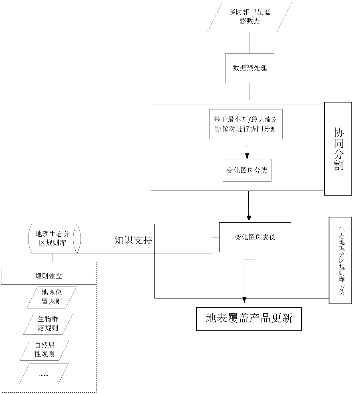
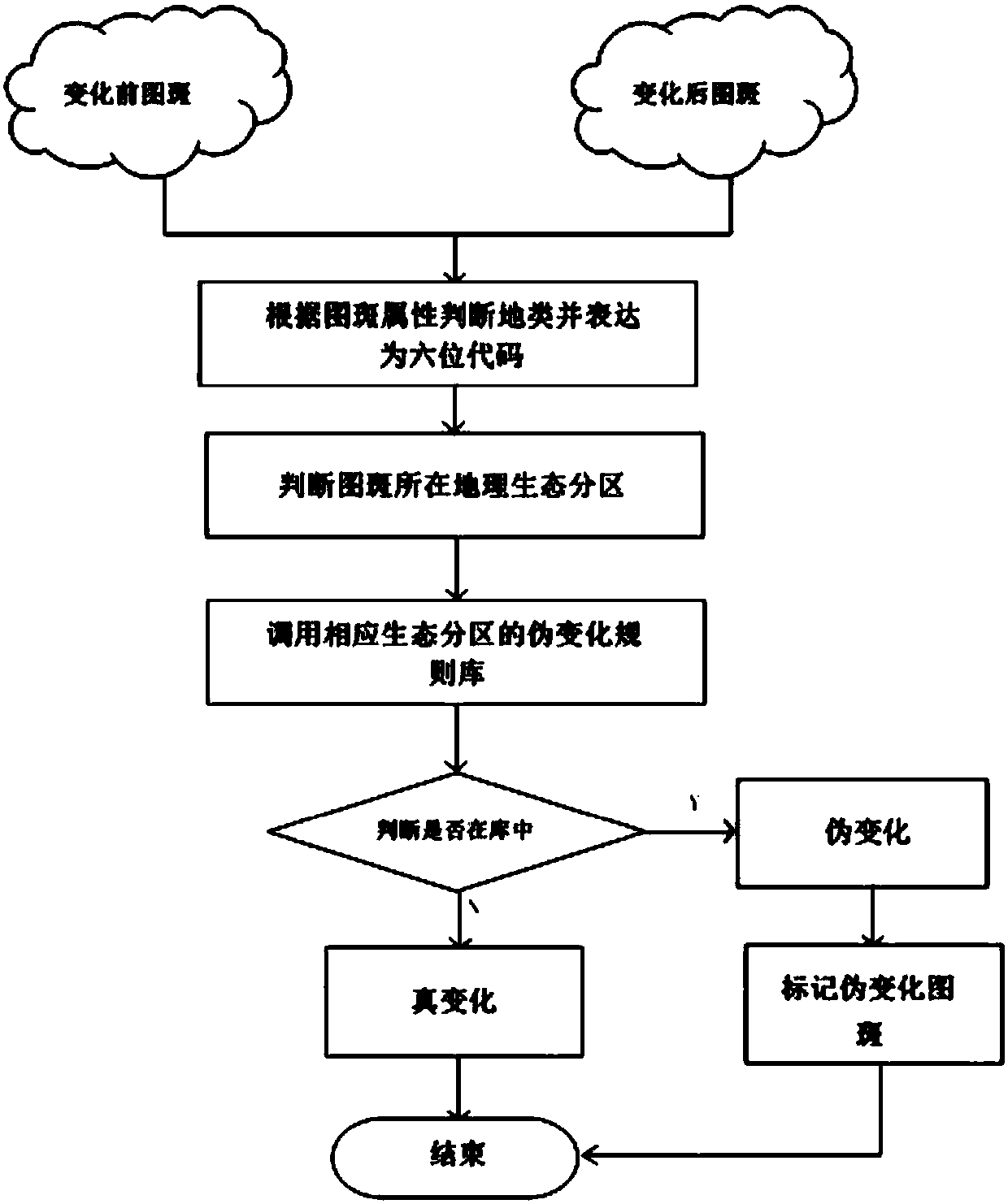
[0119] A method for incremental update of land cover products based on collaborative image segmentation and ecological geographic zoning rule base described in the present invention, such as figure 1 As shown, it includes collaborative segmentation to extract the change patterns of the two phases of images; using the ecological geographic zoning rule base to identify and eliminate false changes; updating land cover products; the specific steps are as follows:

[0120] 1. Multi-temporal remote sensing image collaborative segmentation technology

[0121] 1) Obtain the change intensity map

[0122] In order to ensure the quality of the change intensity map, the two phases of original remote sensing images need to be preprocessed by conventional methods (geometric preprocessing, radiation preprocessing).

[0123] The changing intensity map is based on the spectral characteristics of the image, and the changing intensity value (CV pixel ) is to obtain the absolute value of the di...


PUM


Abstract

A ground cover product increment updating method based on image collaborative segmentation and an eco-geographical zone rule bank. The method includes: collaboratively segmenting and extracting changeimage spots of a phase-two image; utilizing the eco-geographical zone rule bank to recognize and eliminate pseudo change; updating a ground cover product. The method specifically includes following steps: 1, adopting multi-temporal remote-sensing image collaborative segmentation technology; 2, adopting pseudo eliminating technology of the change image spots of the eco-geographical zone rule bank;3, updating the ground cover product. The technical problem of utilizing a multi-temporal satellite image, adopting collaborative segmentation technology to extract ground cover increment, namely ground cover change, classifying the change image spots, combining a global eco-geographical zone rule bank to perform pseudo eliminating change on classified increment image spots to improve reliabilityof an increment detection result and using increment image spots to update an old-temporal ground cover product to acquire a new ground cover product.

Description

technical field [0001] The invention relates to the field of surface change detection based on remote sensing image and update of land cover products. Background technique [0002] The current global land cover products and updates are as follows: [0003] 1. IGBP-DIS (International Geosphere-Biosphere Program Data and Information System, referred to as IGBP-DIS) products are mainly produced by the method of the United States Geological Survey (USGS). The land cover products in the Global Land Cover Characteristics Database (GLCC) database are Obtained by unsupervised classification of NDVI products of AVHRR at 1 km resolution. The images are AVHRR remote sensing data from April 1992 to March 1993. The IGBP-DIS data classification system adopts the classification system of IGBP [1]. [0004] 2. The Department of Geography at the University of Maryland (UMD) used the same image data as IGBP-DIS, including 5-band images of AVHRR satellite images and NDVI data, and used the ...

Claims


Application Information

Patent Timeline
IPC IPC(8): G06F8/20G06T7/00G06T7/136G06K9/62G06K9/46
CPCG06F8/20G06T7/0002G06T7/136G06T2207/30181G06T2207/10032G06V10/462G06F18/24
Inventor 朱凌石若明谢振雷陈旭孙杨剌怡璇
Owner BEIJING UNIVERSITY OF CIVIL ENGINEERING AND ARCHITECTURE
Why Eureka
Try Eureka