Inertial information auxiliary satellite deep combined loop

An auxiliary satellite and deep combination technology, applied in satellite radio beacon positioning systems, measuring devices, instruments, etc., can solve problems such as signal processing difficulties, satellite signals are susceptible to interference, and limit the application of satellite navigation systems, so as to improve tracking sensitivity , easy engineering implementation, simple algorithm application effect

Active Publication Date: 2018-06-01
BEIJING AUTOMATION CONTROL EQUIP INST
View PDF13 Cites 2 Cited by
  • Summary
  • Abstract
  • Description
  • Claims
  • Application Information

AI Technical Summary

Problems solved by technology

Satellite navigation is a passive navigation method that relies entirely on the availability of satellite signals. However, due to the susceptibility of satellite...

Method used


Image

  • Inertial information auxiliary satellite deep combined loop
  • Inertial information auxiliary satellite deep combined loop
  • Inertial information auxiliary satellite deep combined loop

Examples


Embodiment Construction

[0055] The present invention will be further described below by means of the accompanying drawings and specific embodiments.

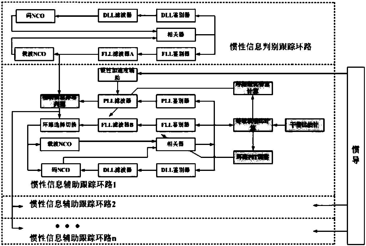
[0056] Inertial information-assisted satellite receiver data fusion processing algorithm is a design method of satellite signal carrier tracking loop assisted by inertial information. Aiming at the reliability of carrier loop design and the optimality of tracking performance, it mainly involves the design of two aspects: Carrier tracking loop implementation structure and loop adaptive parameter adjustment algorithm.

[0057] The inertial information assisted satellite deep combined loop designed in the present invention is composed of two parts: an inertial information discrimination tracking loop and an inertial information assisted tracking loop.

[0058] The inertial information discrimination tracking loop uses a second-order frequency-locked loop to maintain tracking of a satellite. The satellite to be tracked should be the satellite with the lar...


PUM


Abstract

The invention relates to the field of the design of satellite navigation receivers, and specifically discloses an inertial information auxiliary satellite deep combined loop. The inertial informationauxiliary satellite deep combined loop comprises an inertial information auxiliary tracking loop and an inertial information discriminant tracking loop. The inertial information auxiliary tracking loop comprises an auxiliary information anomaly discrimination module, an inertial acceleration auxiliary module, a loop optimal bandwidth calculation module, an equivalent carrier-to-noise ratio calculation module, an interference-to-signal ratio estimation module and a loop PIT adjustment module, which are connected with the output end of the inertial information discriminant tracking loop. The inertial information auxiliary satellite deep combined loop further comprises a correlator and a three-path loop connected with the output end of the correlator. Through full fusion of inertial information and satellite navigation information, reliable design of a satellite receiver and optimal design of the parameters are realized. The algorithm is simple to apply. There is no complex equation or equation needing heavy computation. Algorithm programming on a DSP or FPGA hardware platform can be guaranteed in the aspects of both real-time performance and amount of computation, namely, engineeringimplementation is easy.

Description

technical field [0001] The invention belongs to the design field of satellite navigation receivers, and in particular relates to an inertial information auxiliary satellite deep combination loop for improving the performance of a satellite navigation receiver by inertial auxiliary information. Background technique [0002] The inertial navigation system has become an indispensable and important part of the fields of aviation, aerospace, navigation, land navigation and geodesy. It has outstanding advantages such as autonomy, strong concealment, all-weather, anti-interference, large output information, and strong real-time output information. , but its disadvantage is that the accuracy will decrease with time. Satellite navigation system (GPS, GLONASS, Beidou, etc.) is an all-weather, real-time, high-precision navigation and positioning system that provides users with position, speed, and time information, and has been widely used in military and civilian fields. Satellite na...

Claims


Application Information

Patent Timeline
IPC IPC(8): G01S19/31
CPCG01S19/31
Inventor 左启耀李峰李育龙胡文涛洪诗聘祖秉法刘峰
Owner BEIJING AUTOMATION CONTROL EQUIP INST
Why Eureka
Try Eureka