A Pedestrian Path Matching Method Based on the Alignment of Geomagnetic Field Strength Sequence Feature Points

A technology of magnetic field strength and feature point pairs, which is applied in the direction of navigation, navigation, and instruments through speed/acceleration measurement, which can solve the problems of difficult to accurately calculate the step size and heading, and limited accuracy, so as to avoid errors and reduce time complexity Effect

Active Publication Date: 2021-06-25
ACAD OF OPTO ELECTRONICS CHINESE ACAD OF SCI +1
View PDF5 Cites 0 Cited by
  • Summary
  • Abstract
  • Description
  • Claims
  • Application Information

AI Technical Summary

Problems solved by technology

However, due to the limited accuracy of the built-in inertial device of the smart phone, and the change of the user's posture when using the smart phone, it is difficult to accurately calculate the step length and heading

Method used


Image

  • A Pedestrian Path Matching Method Based on the Alignment of Geomagnetic Field Strength Sequence Feature Points
  • A Pedestrian Path Matching Method Based on the Alignment of Geomagnetic Field Strength Sequence Feature Points
  • A Pedestrian Path Matching Method Based on the Alignment of Geomagnetic Field Strength Sequence Feature Points

Examples


Embodiment Construction

[0045] In order to make the objectives, technical solutions and advantages of the present invention clearer, the present invention will be further described in detail below with reference to the accompanying drawings and embodiments.

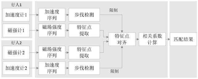
[0046] The present invention provides a pedestrian path matching method based on feature point alignment of geomagnetic field strength sequence, specifically:

[0047] 1. The two sets of magnetic field strength sequences to be processed are Mag 1 and Mag 2 , in the magnetic field strength sequence Mag 1 and Mag 2 Find a set of spatially consistent feature points in the set, and align the two sequences at the set of feature points, and then align the other feature points with the set of feature points as the benchmark; after alignment, the length of the two sequences is unified by linear interpolation , get the new sequence Mag new1 with Mag new2 ;

[0048] 2. Calculate the correlation coefficient cc of the two new sequences;

[0049] 3. R...


PUM


Abstract

The present invention provides a pedestrian path matching method based on the alignment of feature points of geomagnetic field intensity sequences. Align the two sequences at the position, and then align the other feature points with the group of feature points as the benchmark; after alignment, the lengths of the two sequences are unified through linear interpolation, and two new sets of sequences are obtained; 2. Calculate the two new sequences Correlation coefficient; 3. Repeat the above process to obtain the maximum correlation coefficient of the two sequences; 4. Set the similarity threshold, and the two sequences with the maximum correlation coefficient greater than the threshold are judged to be the data of the same road section, and their relative positions are determined by the two sequences after alignment. The relative position of the starting point of the group sequence is determined. The invention realizes the scale unification of the geomagnetic sequence by identifying the characteristic points in the magnetic field sequence, and then realizes the accurate matching of the geomagnetic sequence in the same space.

Description

technical field [0001] The invention belongs to the technical field of indoor positioning, and in particular relates to a pedestrian path matching method based on geomagnetic field intensity sequence feature point alignment, which can be used in fingerprint map construction based on crowdsourcing data and geomagnetic sequence matching and positioning. Background technique [0002] With the rapid development of mobile Internet and smart terminals, various Internet services based on geographical location are continuously derived, and people's demand for indoor positioning is becoming more and more intense. At present, the commonly used indoor positioning methods in mass consumer application scenarios mainly include positioning methods based on WLAN / BLE signal strength fingerprints, indoor positioning methods based on geomagnetic field, and positioning based on inertial sensors. The positioning method based on the signal strength fingerprint needs to collect the signal strength...

Claims


Application Information

Patent Timeline
Patent Type & Authority Patents(China)
IPC IPC(8): G01C21/16
CPCG01C21/165
Inventor 李雯魏东岩纪新春来奇峰李祥红袁洪
Owner ACAD OF OPTO ELECTRONICS CHINESE ACAD OF SCI
Why Eureka
Try Eureka