Geographic space data service integrating method of dynamic configuration oriented to mobile client side

A geospatial data and mobile client technology, applied in geographic information databases, structured data retrieval, electronic digital data processing, etc., can solve problems such as slow display speed, single geographic information service publishing platform, and unsatisfactory application effects

Inactive Publication Date: 2018-06-08
南京市城市规划编制研究中心
View PDF2 Cites 9 Cited by
  • Summary
  • Abstract
  • Description
  • Claims
  • Application Information

AI Technical Summary

Problems solved by technology

[0005] 3) Slow display speed: Spatial data often requires several layers to be superimposed, especially when displaying all spatial data in the full range, fast graphical display of spatial data requires strong computing power on the mobile terminal
[0006] In view of the above technical problems, the existing mainstream solutions often use a single geographic information service release platform, such as using the ArcGIS Server platform to realize the display and query of geospatial data on the mobile terminal based on the MapService service, but the spatial data display It is often difficult to balance both performance and query performance, and the actual application effect is not ideal

Method used


Image

  • Geographic space data service integrating method of dynamic configuration oriented to mobile client side
  • Geographic space data service integrating method of dynamic configuration oriented to mobile client side
  • Geographic space data service integrating method of dynamic configuration oriented to mobile client side

Examples


Embodiment Construction

[0020] This embodiment illustrates the specific implementation of the method of the present invention in conjunction with the accompanying drawings.

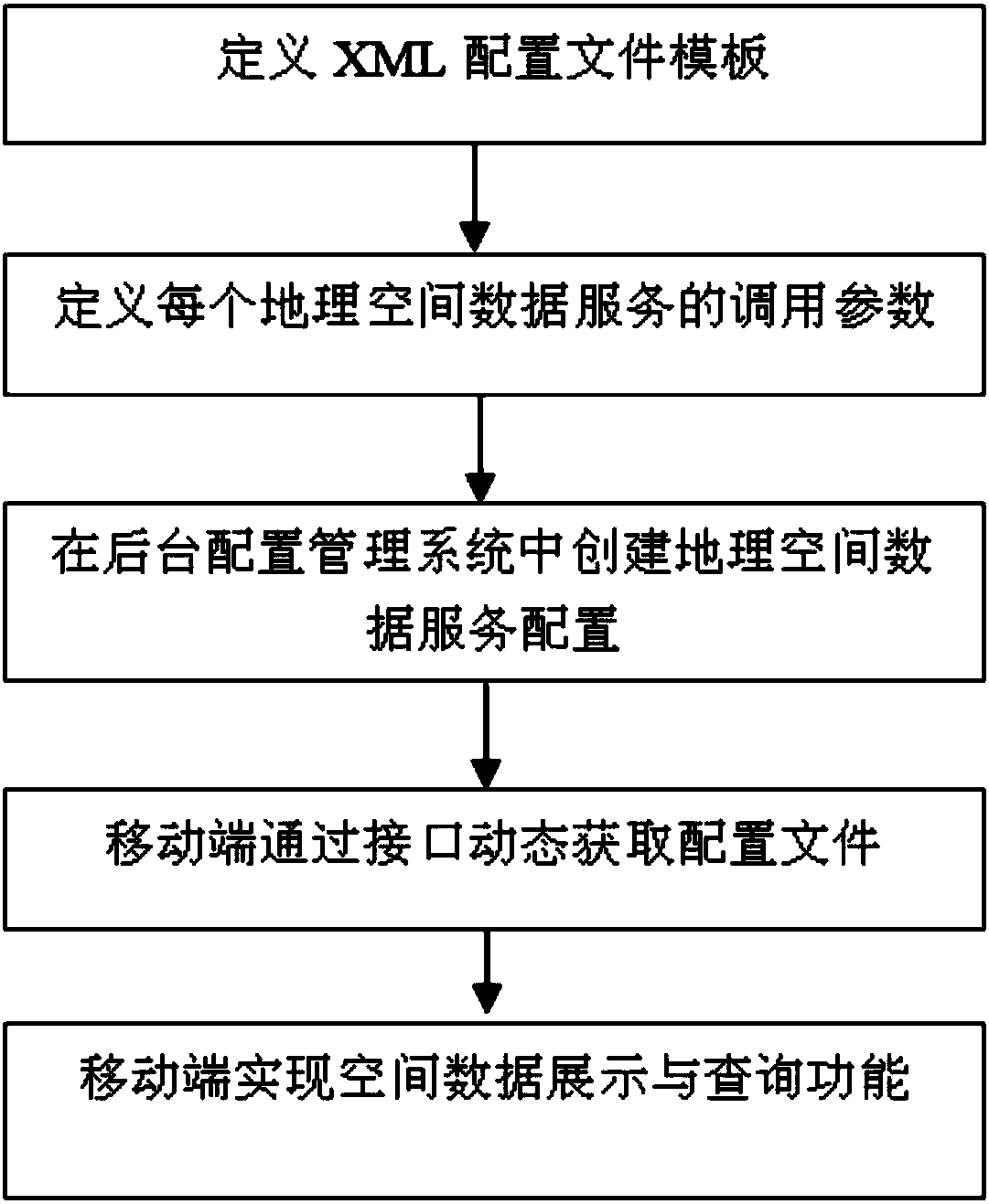
[0021] The present invention combines online data services with dynamic configuration files, and flexibly implements fast display and query of various geospatial data services on the mobile terminal in a loosely coupled manner. The steps are as follows (such as figure 1 shown):

[0022] First, define a configuration file template in XML format to specify the structure and general parameters of the configuration file. XML, or Extensible Markup Language, is a markup language used to mark electronic documents to make them structured. It can be used to mark data, define data types, and is a source language that allows users to define their own markup language. It is well suited for World Wide Web transport, providing a unified method for describing and exchanging structured data independent of application or vendor. The configur...


PUM


Abstract

The invention discloses a geographic space data service integrating method of dynamic configuration oriented to a mobile client side. The method includes the following steps of firstly, defining an XML configuration file template to regulate the structural and universal parameters of a dynamic configuration file; secondly, analyzing and collecting the types of existing geographic space data service, and defining calling parameters of all geographic space data service; thirdly, establishing geographic space data service configuration in a background configuration management system; fourthly, dynamically obtaining a configuration file by a mobile side through a service interface; fifthly, achieving a space data displaying and inquiring function by the mobile side. By means of the method, thedynamic configuration of all geographic space data integrated in the mobile client side can be realized, the application requirements for rapid displaying and inquiring on the mobile client side aremet, and the user experience of geographic space data application under the mobile side environment is greatly improved.

Description

technical field [0001] The invention relates to an integration technology of geospatial data services on a mobile client, in particular to a method for quickly displaying and querying multi-source heterogeneous geospatial data services on a mobile client. Background technique [0002] The integration of geospatial data services on mobile clients has the following characteristics: [0003] 1) Various data formats: the storage and access methods of geospatial data are not the same. There are online services and offline data packages. Online services include services that meet OGC standards, and there are also private services for each GIS platform. Offline data packages There are vector data packages and there are slice data packages. [0004] 2) Large amount of data: Whether it is basic surveying and mapping data or thematic spatial data, the amount of data is relatively huge, especially for large-scale data, there are a large number of complex line and surface data, and the...

Claims


Application Information

Patent Timeline
Patent Type & Authority Applications(China)
IPC IPC(8): G06F17/30G06F8/71
CPCG06F8/71G06F16/29
Inventor 郑晓华王芙蓉陈踊崔蓓赵伟王树魁毛燕翎诸敏秋吴掠桅
Owner 南京市城市规划编制研究中心
Why Eureka
Try Eureka