Surveying and mapping unmanned aerial vehicle with camera protection function

A protection function and UAV technology, applied in the field of aerial photography surveying and mapping, can solve the problems of unsatisfactory shooting effect, easy damage, and large limitation of camera activity range, etc., to achieve dust cover reduction, strong versatility, and reasonable design Effect

Inactive Publication Date: 2018-06-22
CHENGDU RAINPOO TECH CO LTD
View PDF0 Cites 9 Cited by
  • Summary
  • Abstract
  • Description
  • Claims
  • Application Information

AI Technical Summary

Problems solved by technology

With the continuous development of aerial survey technology, because drones are affected by the weather and the image of the airport is small, the application of drone aerial survey technology in the field of aerial surveying and mapping is increasing. Traditional drone aerial surveying and mapping uses cameras or cameras to complete the work. The camera device is exposed. On the one hand, it is completely unprotected and easily damaged. On the other hand, it is easily blinded by the dust in the air, so that the shooting effect cannot meet the requirements.
At the same time, due to the limitation of the landing gear, when the camera is equipped with a telephoto lens, the range of movement of the camera is greatly limited by the landing gear

Method used


Image

  • Surveying and mapping unmanned aerial vehicle with camera protection function
  • Surveying and mapping unmanned aerial vehicle with camera protection function
  • Surveying and mapping unmanned aerial vehicle with camera protection function

Examples


Embodiment Construction

[0018] In order to have a clearer understanding of the technical features, purposes and effects of the present invention, the specific embodiments of the present invention will now be described with reference to the accompanying drawings, but the protection scope of the present invention is not limited to the following.

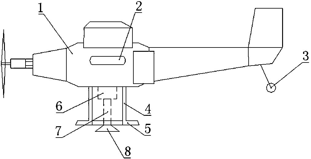
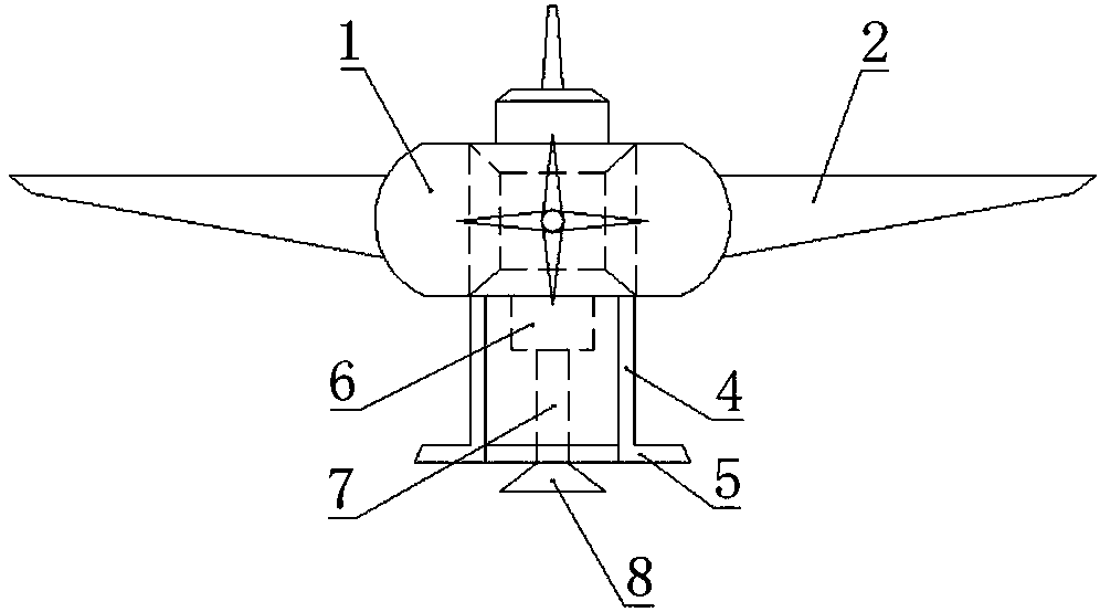
[0019] like Figures 1~3 As shown, a surveying and mapping drone with a camera protection function mainly includes a fuselage 1 , wings 2 symmetrically arranged on both sides of the fuselage 1 , and an engine arranged inside the fuselage 1 .

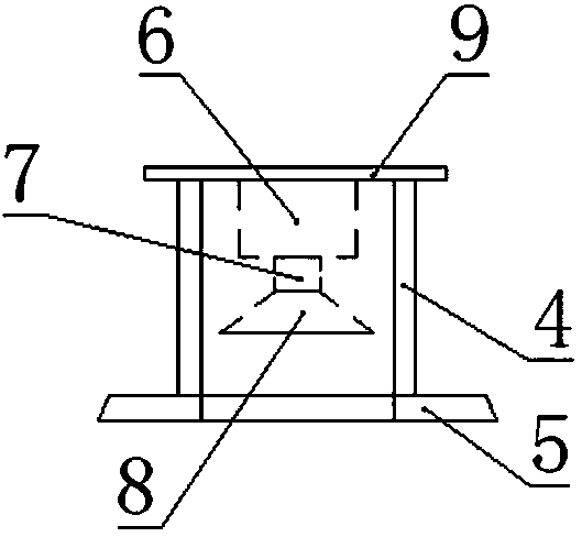
[0020] like Figures 1~3 As shown, the UAV for surveying and mapping also includes a camera device, and the camera device is fixed on the lower side of the fuselage 1; the upper part of the camera device is provided with a connecting plate 9, and the connecting plate 9 is circular and has a diameter of 30 cm. The thickness is 0.5cm, which is parallel to the horizontal plane, and the connecting plate 9 is fixed to the b...


PUM


Abstract

The invention discloses a surveying and mapping unmanned aerial vehicle with a camera protection function. The surveying and mapping unmanned aerial vehicle mainly comprises a body, wings, an engine and a camera shooting device, the wings are symmetrically arranged on two sides of the body, the engine is arranged in the body, the camera shooting device is fixed onto the lower side of the body, a connecting plate is arranged on the upper portion of the camera shooting device and fixedly connected at the bottom of the body, supporting legs are arrange don the lower side of the connecting plate and used for supporting when the surveying and mapping unmanned aerial vehicle falls down to the ground, a power device is arrange don the lower side of the connecting plate and can provide power pushing action, and a camera is fixedly connected on the lower side of the power device. The surveying and mapping unmanned aerial vehicle has the advantages that a telephoto lens can be installed on an aerial camera of the unmanned aerial vehicle without damaging the camera when the unmanned aerial vehicle lands, the unmanned aerial vehicle is provided with a camera installation structure, dust covering is decreased, shooting effects are ensured, the service life of the camera is prolonged, and the unmanned aerial vehicle is integrated in structure and high in universality.

Description

technical field [0001] The invention relates to the field of aerial photography surveying and mapping, in particular to a surveying and mapping unmanned aerial vehicle with a camera protection function. Background technique [0002] Aerial photography, also known as aerial photography or aerial photography, refers to photographing the earth's landforms from the air to obtain a top-down view, which is an aerial photo. UAV is an unmanned aircraft controlled by radio remote control equipment or onboard computer program control system. UAVs can not only complete tasks performed by manned aircraft, but are also suitable for tasks that are not suitable for manned aircraft. With the continuous development of aerial survey technology, because drones are affected by the weather and the image of the airport is small, the application of drone aerial survey technology in the field of aerial surveying and mapping is increasing. Traditional drone aerial surveying and mapping use cameras ...

Claims


Application Information

Patent Timeline
Patent Type & Authority Applications(China)
IPC IPC(8): B64D47/08B64C25/06B64C25/64B64C39/02
CPCB64C25/06B64C25/64B64C39/02B64D47/08B64U10/25B64U2101/30
Inventor 杨润朱鸿颖涛何世雄李小龙
Owner CHENGDU RAINPOO TECH CO LTD
Why Eureka
Try Eureka