Simulation Method and Simulator for Underwater Terrain Measurement

A technology of underwater terrain and simulation method, which is applied in the direction of measuring device, open-air water source survey, measurement of the depth of open-air water source, etc., can solve the problem of inability to learn underwater terrain simulation method

Active Publication Date: 2020-07-14
PLA DALIAN NAVAL ACADEMY
View PDF4 Cites 0 Cited by
  • Summary
  • Abstract
  • Description
  • Claims
  • Application Information

AI Technical Summary

Problems solved by technology

Through this demonstration function, users can only master the most basic operation method of the bathymetry system, and cannot learn the underwater terrain simulation method in the real underwater environment

Method used


Image

  • Simulation Method and Simulator for Underwater Terrain Measurement
  • Simulation Method and Simulator for Underwater Terrain Measurement
  • Simulation Method and Simulator for Underwater Terrain Measurement

Examples


Embodiment Construction

[0087] In order to make the purpose, technical solution and advantages of the present invention clearer, the following will be described in conjunction with the accompanying drawings and specific examples of the description.

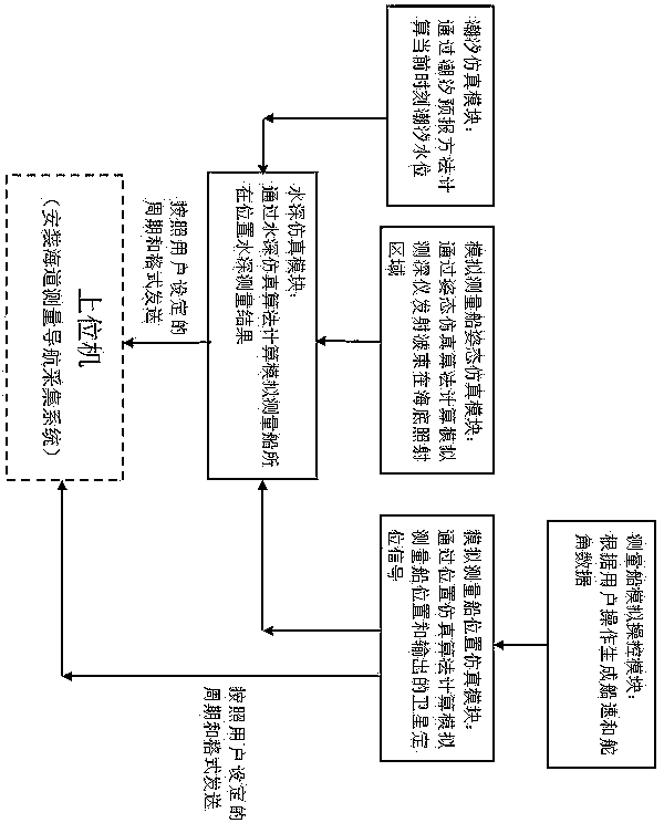
[0088] The purpose of the present invention is to simulate the whole process of underwater topography measurement, to be able to steer and simulate the navigation of the survey ship, and to provide real-time data on the position of the survey ship and the water depth at the location for the upper computer installed with the underwater topography survey navigation acquisition software. A simulation method for underwater terrain surveying, the specific steps comprising:

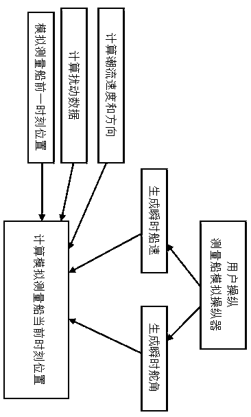
[0089] Step 1: The user changes the simulated ship speed and rudder angle of the simulated survey ship through the simulated manipulator of the survey ship, and the underwater terrain survey simulator is controlled by the internal clock of the system according to the speed and rudder angle...


PUM


Abstract

The invention relates to the technical field of marine charting, specifically to an underwater topographic survey simulation method and a simulator thereof. The method comprises the following steps: changing the ship speed and rudder angle of a simulated surveying ship by using a simulated controller of the surveying ship by a user, and calculating and simulating the position of the surveying shipaccording to a position simulation algorithm; sending a GPS positioning signal to an upper computer according to a positioning signal simulation algorithm; generating the depth finder sound wave transmitting direction of a ship posture according to a posture simulation algorithm of the surveying ship; calculating instantaneous tide water level height according to a tide prediction algorithm in the period defined by the user; calculating a measurement result of instantaneous water depth according to a water depth simulation algorithm, and sending the measurement result to the upper computer for installing underwater topographic survey navigation collection software. Under the premise of no wading measurement, the measurement result similar to real water depth measurement is provided for hydrographic sounding navigation collection software. A vivid water depth measurement environment is provided for the user through a simulated underwater topographic survey signal generated by a simulation system.

Description

technical field [0001] The invention relates to the technical field of marine surveying and mapping, in particular to an underwater terrain surveying simulation method and a simulator thereof. Background technique [0002] At present, with the full development of marine and inland water resources, the demand for underwater topographic survey has increased dramatically, requiring a large number of experienced underwater topographic surveyors. Underwater topographic survey requires high work experience for surveyors. Experienced surveyors can carry out correct surveys of various underwater targets according to hydrographic survey standards, and can also correctly handle the impact caused by changes in sea conditions and hydrological parameters during the survey process. influence on the measurement results. However, since the underwater topographic survey needs to be carried out by survey ships in the ocean or inland rivers, the cost is relatively high. General colleges and ...

Claims


Application Information

Patent Timeline
Patent Type & Authority Patents(China)
IPC IPC(8): G01C7/04G01C13/00G09B9/00
CPCG01C7/04G01C13/00G01C13/008G09B9/00Y02A90/30
Inventor 刘天阳徐卫明许坚
Owner PLA DALIAN NAVAL ACADEMY
Why Eureka
Try Eureka