Method for determining entrance into and exit from polygonal area of moving point

An implementation method and technology of moving points, applied in image data processing, measuring devices, instruments, etc., can solve problems such as limiting the speed of judgment, and achieve the effect of reducing the difficulty of implementation

Inactive Publication Date: 2018-07-10
WUHAN YANGTZE COMM ZHILIAN TECH
View PDF2 Cites 4 Cited by
  • Summary
  • Abstract
  • Description
  • Claims
  • Application Information

AI Technical Summary

Problems solved by technology

[0009] If the amount of point data is large, for example, to judge whether millions of points are within a polygon, it i

Method used


Image

  • Method for determining entrance into and exit from polygonal area of moving point
  • Method for determining entrance into and exit from polygonal area of moving point

Examples


Embodiment Construction

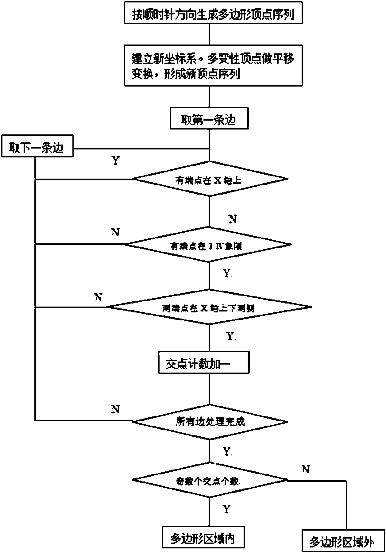
[0037] The present invention will be further described below in conjunction with the accompanying drawings.

[0038] An implementation method for judging whether a moving point enters or exits a polygon. The position of the moving point is represented by plane coordinates. The X-axis is the longitude, and the east longitude is the positive direction of the X-axis; the Y-axis is the latitude, and the north latitude is the positive direction of the Y-axis; the polygon is composed of three or three The plane figure formed by connecting the above line segments head to tail in sequence is represented by a set of vertex sequences; starting from the starting vertex, passing through all the vertices in a clockwise direction, and finally returning to the starting point, a closed shape is formed; two adjacent Line segments with points as endpoints are the sides of a polygon.

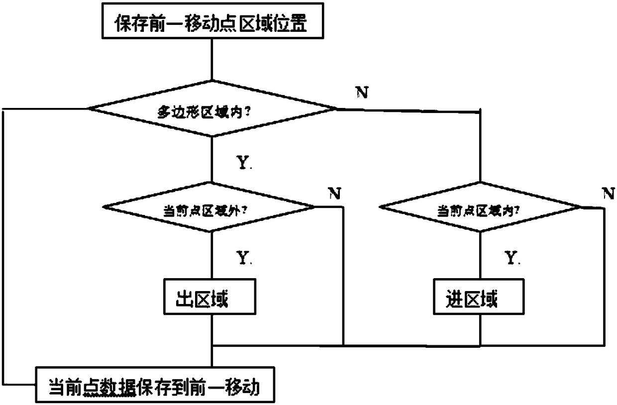
[0039] The detection method comprises the following steps: continuously detecting the position of the moving po...


PUM


Abstract

The invention relates to a method for determining entrance into and exit from polygonal area of a moving point. The position of the point is represented by a planar coordinate in which axis X represents the longitude with the positive direction of the axis X referring to east longitude and axis Y represents the latitude with the positive direction of the axis Y referring to northern latitude; anda polygon is a planar figure formed by connecting three or more line segments in an end-to-end manner, and is represented by a sequence of vertexes. The method comprises the following steps that S1) the position of the moving point is detected continuously, and whether the moving point is inside or outside the polygon is determined; and S2) whether the point enters into or exist from the polygonalarea is determined. Whether the moving point is inside or outside the polygonal area is determined via simple coordinate translation, value multiply and value symbol determination, and the realization difficulty is reduced.

Description

technical field [0001] The invention belongs to the technical field of location-based service applications, and in particular relates to an implementation method for judging whether a moving point enters or exits a polygonal area. Background technique [0002] Location-based services, also known as location-based services, refer to the mutual cooperation between mobile terminals and mobile networks, based on spatial databases, to determine the actual geographic location of mobile users, thereby providing location-related service information required by users. [0003] Location-based services provide users with spatial information services through the application of satellite navigation and positioning technology and mobile communication technology, with the support of map databases, through convenient and effective operations, telling others where a specific object is, where it is going, what is around it, etc. . [0004] Location-based services have been widely used in fre...

Claims


Application Information

Patent Timeline
IPC IPC(8): G06T7/70G01B21/00
CPCG01B21/00G06T7/70
Inventor 陈闽海
Owner WUHAN YANGTZE COMM ZHILIAN TECH
Why Eureka
Try Eureka