Display method, device, terminal and readable storage medium for map labeling information
A technology for labeling information and displaying devices, applied in the computer field, can solve problems affecting user experience, increase of smart terminals, and unsmooth operation, and achieve the effects of increasing user experience, reducing operating burden, and improving fluency
- Summary
- Abstract
- Description
- Claims
- Application Information
AI Technical Summary
Problems solved by technology
Method used
Image
Examples
Embodiment 1
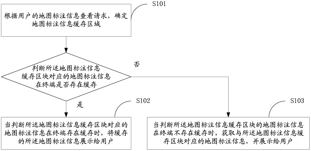
[0034] figure 1 It shows a flow chart of realizing the method for displaying map labeling information provided by Embodiment 1 of the present invention. For convenience of description, only the parts related to the present invention are shown.
[0035] In step S101 , according to a map annotation information viewing request of a user, a map annotation information cache area is determined, and the map annotation information cache area includes at least one map annotation information cache block.
[0036] In the embodiment of the present invention, the map annotation information refers to the application data displayed on the map, and the map annotation information may be information such as the location on the map of the parking lot applied to the parking client, the name of the parking lot, and the vacant parking spaces of the parking lot. It can also be the location on the map of the shared bicycle applied to the shared bicycle client, the model information of the shared bicy...
Embodiment 2
[0051] Figure 6 It shows a flow chart of realizing the method for displaying map annotation information provided by Embodiment 2 of the present invention, and for the convenience of description, only the parts related to the present invention are shown.
[0052] Step S101 includes step S601 and step S602.
[0053] In step S601, the coordinates of the information cache reference point are determined according to the user's map annotation information viewing request.
[0054] In the embodiment of the present invention, the cached reference point refers to the point where the cached map annotation information is viewed.
[0055] Among them, when the user drags or slides the electronic map through the display interface, a comparison point will be preset on the display interface. After the dragging or sliding operation is completed, the point on the electronic map that coincides with the comparison point is used as information Cache reference point. As an example, when the user...
Embodiment 3
[0065] Figure 9 It shows a flow chart of realizing the method for displaying map annotation information provided by Embodiment 3 of the present invention, and for the convenience of description, only the parts related to the present invention are shown.
[0066] Step S201 includes step S901 and step S902.
[0067] In step S901, the map area displayed in the information display window is determined according to the user's request for viewing map annotation information.
[0068] In the embodiment of the present invention, the information display window refers to the display screen of the terminal.
[0069] In the embodiment of the present invention, the displayed map area refers to the corresponding area in the electronic map according to the size of the screen of the user terminal.
[0070] Wherein, the map area in the screen display area may be determined by determining the latitude and longitude of the two points on the map at the bottom left and the top right of the scree...
PUM
 Abstract
Description
Claims
Application Information
 - R&D
- Intellectual Property
- Life Sciences
- Materials
- Tech Scout
- Unparalleled Data Quality
- Higher Quality Content
- 60% Fewer Hallucinations
Browse by: Latest US Patents, China's latest patents, Technical Efficacy Thesaurus, Application Domain, Technology Topic, Popular Technical Reports.
© 2025 PatSnap. All rights reserved.Legal|Privacy policy|Modern Slavery Act Transparency Statement|Sitemap|About US| Contact US: help@patsnap.com


