
Large-scale network RTK positioning method and system based on spatial clustering

A technology of spatial clustering and positioning methods, applied in satellite radio beacon positioning systems, radio wave measurement systems, instruments, etc., to achieve large-scale concurrent user access, good adaptability, and easy management

Active Publication Date: 2018-08-17
WUHAN UNIV
View PDF5 Cites 11 Cited by
  • Summary
  • Abstract
  • Description
  • Claims
  • Application Information

AI Technical Summary

Problems solved by technology

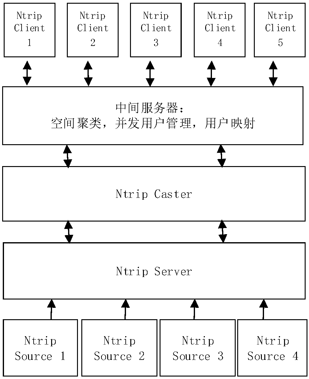
[0005] The purpose of the present invention is to provide a large-scale network RTK positioning method and system based on spatial clustering, and the present invention can solve the problem of data center computing pressure caused by large-scale users accessing the CORS network

Method used


Image

  • Large-scale network RTK positioning method and system based on spatial clustering
  • Large-scale network RTK positioning method and system based on spatial clustering
  • Large-scale network RTK positioning method and system based on spatial clustering

Examples


Embodiment Construction

[0034] In order to illustrate the present invention and / or the technical solutions in the prior art more clearly, the specific implementation manners of the present invention will be described below with reference to the accompanying drawings. Obviously, the accompanying drawings in the following description are only some embodiments of the present invention, and those skilled in the art can obtain other accompanying drawings based on these drawings and obtain other implementations.

[0035] It should be understood that the specific embodiments described here are only used to explain the present invention, not to limit the present invention. In addition, the technical features involved in the various embodiments of the present invention described below can be combined with each other as long as they do not constitute a conflict with each other.

[0036] It should be noted that the CORS reference station mentioned below is a continuous operation reference station, and the user...


PUM


Abstract

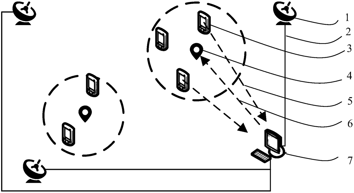
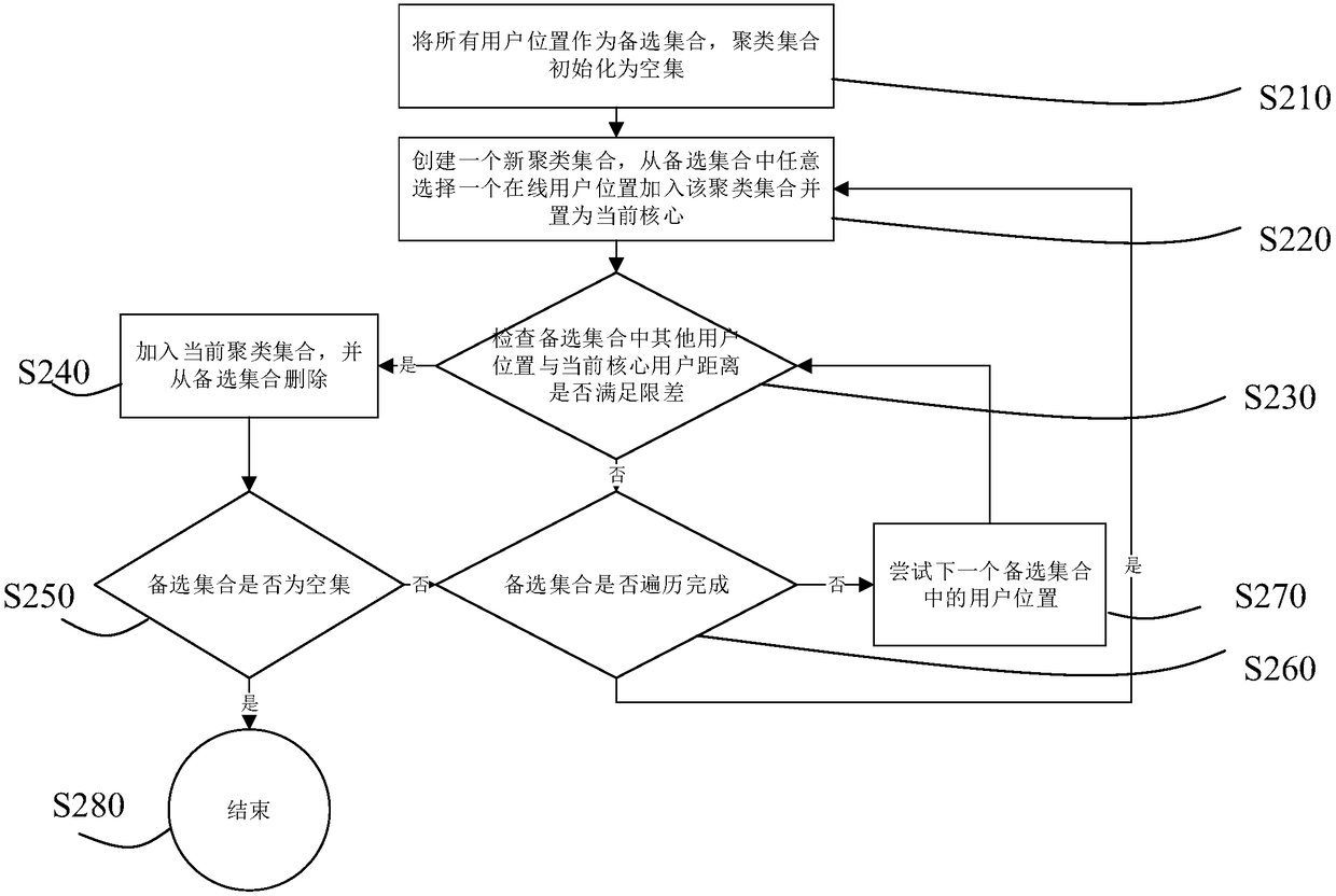
The invention discloses a large-scale network RTK positioning method and system based on spatial clustering. The method comprises the following steps of (1) according to a user position, carrying outspatial clustering on a user; (2) according to an area where each type of users are located, determining a virtual reference station position which is the common virtual reference station position ofeach type of users, wherein the common virtual reference station position of each type of users is located in the area where each type of users are located; (3) according to the real-time observationdata flow of a CORS reference station and a virtual reference station position, calculating and generating a virtual reference station observation value which is the common virtual reference station observation value of each type of users; and (4) using the common virtual reference station observation value to carry out RTK positioning by each type of users. In the invention, a lot of users can besupported to be in an online state simultaneously and concurrently and are not limited by a server calculating resource, and a contradiction between the number of concurrent users and the limited calculating resources in large-scale network RTK system construction is solved.

Description

technical field [0001] The invention belongs to the field of surveying and mapping and precise positioning, and in particular relates to a large-scale network RTK positioning method and system based on spatial clustering. Background technique [0002] As an important means of GNSS precise positioning, network RTK (real-time dynamic carrier phase differential positioning) has been widely used at home and abroad. Network RTK uses the real-time GNSS observation data of the Continuous Operation Reference Station System (CORS) to process, calculate the GNSS observation corrections in the CORS network area, and broadcast them to users. A technique in which the user end uses the received corrections to improve its own positioning accuracy. It belongs to a differential precision positioning technology, which can realize precise positioning with an accuracy of 2cm to 3cm in the plane and 5cm in elevation. Compared with single-base RTK, network RTK has the advantages of wide service...

Claims


Application Information

Patent Timeline
Patent Type & Authority Applications(China)
IPC IPC(8): G01S19/43
CPCG01S19/43
Inventor 申丽丽王磊郭际明
Owner WUHAN UNIV
Learn More