Method for selecting taking-off and landing point for fixed-wing unmanned aerial vehicle in urban area

A fixed-wing, aircraft city technology, applied in the field of UAV aerial survey, can solve the problems of urban environment without special classification processing, the UAV deviates from the predetermined landing point, and the take-off and landing point takes a lot of time, so as to reduce the aerial survey. cost, ensuring safe take-off and landing, and good control

Active Publication Date: 2018-09-07
NORTH CHINA UNIV OF WATER RESOURCES & ELECTRIC POWER
View PDF5 Cites 2 Cited by
  • Summary
  • Abstract
  • Description
  • Claims
  • Application Information

AI Technical Summary

Problems solved by technology

The selection of take-off and landing points takes a lot of time, resulting in a waste of manpower and material resources
In addition, the existing methods for selecting take-off and landing points in urban areas for drones are all aimed at the ideal urban environment, and there is no special detailed classification of the urban environment, and there are no measures to deal with the impact of sudden weather conditions; the most important Yes, the existing methods for selecting take-off and landing points in urban areas for UAVs do not have special aerial survey correction measures, and UAVs tend to deviate from the scheduled landing points, and cannot perform safe take-off and landing in urban areas very well and accurately.

Method used


Image

  • Method for selecting taking-off and landing point for fixed-wing unmanned aerial vehicle in urban area
  • Method for selecting taking-off and landing point for fixed-wing unmanned aerial vehicle in urban area

Examples


Embodiment Construction

[0038] Specific examples are given below to further describe the technical solution of the present invention in a clear, complete and detailed manner. This embodiment is the best embodiment on the premise of the technical solution of the present invention, but the protection scope of the present invention is not limited to the following embodiments.

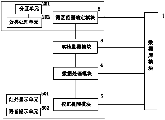
[0039] The method for selecting take-off and landing points in urban areas of fixed-wing unmanned aerial vehicle of the present invention, such as figure 1 As shown, the selection system used in this selection method includes a database module 1, and also includes a sequentially connected survey area range determination module 2, field survey module 3, data processing module 4 and correction reminder module 5, the survey area range determination module 2 , field survey module 3, data processing module 4, correction reminder module 5 are connected with described database module 1 respectively;

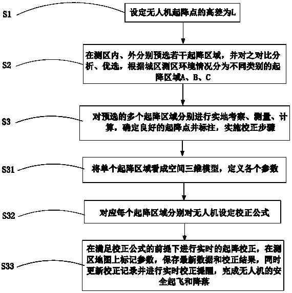
[0040] like figure 2 As shown, t...


PUM


Abstract

The invention provides a selecting system. The selecting system comprises a database module and further comprises a measuring area range determining module, a site investigation module, a data processing module and a correction prompting module which are connected with each other in sequence. A method for selecting a taking-off and landing point for a fixed-wing unmanned aerial vehicle in an urbanarea comprises the steps of setting a height difference L of an unmanned aerial vehicle taking-off and landing point, pre-selecting a taking-off and landing area and selecting the taking-off and landing area in an optimized manner, determining the taking-off and landing point and implementing correction. According to the selecting system, real-time performance and high efficiency are realized, the accuracy is high, and the control degree is good; the optimized selection of the taking-off and landing point in the urban environment is rapidly realized according to a selection principle so thatthe aerial survey accuracy of the fixed-wing unmanned aerial vehicle is greatly improved; as the precondition that the unmanned aerial vehicle flies forwards for 10-20 m more during landing when the height difference of the taking-off and landing point is increased by 1 m every time is taken into consideration, and the correction step of preventing the unmanned aerial vehicle from being biased from a preset landing point is set, the taking-off and landing error is greatly reduced, the safety taking-off and landing of the unmanned aerial vehicle are guaranteed, the aerial survey cost of the unmanned aerial vehicle is greatly reduced, the workload is reduced, and the selecting system is more suitable for being popularized.

Description

technical field [0001] The invention belongs to the field of unmanned aerial vehicle aerial survey technology, and relates to the take-off and landing technology of fixed-wing unmanned aerial vehicles, and more specifically, relates to a method for selecting take-off and landing points in urban areas of fixed-wing unmanned aerial vehicles. Background technique [0002] As we all know, fixed-wing UAVs have a wide range of aerial surveys, high speed, and high efficiency. Harsh. Trimble UX5 UAV needs a flat land with a length of at least 50 meters and a width of 30 meters. It is best to choose a field that is open, relatively soft and free of hard objects such as stones, and try to avoid hard landing on cement roads. When performing surveying and mapping tasks, it is inevitable to encounter more complex terrain conditions, and it is impossible to find a large area of ​​open space, which is extremely unfavorable for the safe landing of drones. In urban areas, high-rise buildin...

Claims


Application Information

Patent Timeline
Patent Type & Authority Applications(China)
IPC IPC(8): B64D45/04
CPCB64D45/04B64U10/25B64U70/60
Inventor 王博王富强吴瀚范天雨田振兴聂相田
Owner NORTH CHINA UNIV OF WATER RESOURCES & ELECTRIC POWER
Why Eureka
Try Eureka