Road three-dimensional model modeling method based on lane-level high-precision map

A technology of 3D model and modeling method, applied in 3D modeling, image enhancement, image analysis, etc., can solve the problem of insufficient information, achieve the effect of convenient operation and reduce workload

Active Publication Date: 2018-11-30
广东星舆科技有限公司
View PDF9 Cites 15 Cited by
  • Summary
  • Abstract
  • Description
  • Claims
  • Application Information

AI Technical Summary

Problems solved by technology

[0005] In view of the above reasons, the present invention provides a road three-dimensional modeling method based on a lane-level high-precision map to solve th...

Method used


Image

  • Road three-dimensional model modeling method based on lane-level high-precision map
  • Road three-dimensional model modeling method based on lane-level high-precision map
  • Road three-dimensional model modeling method based on lane-level high-precision map

Examples


Embodiment Construction

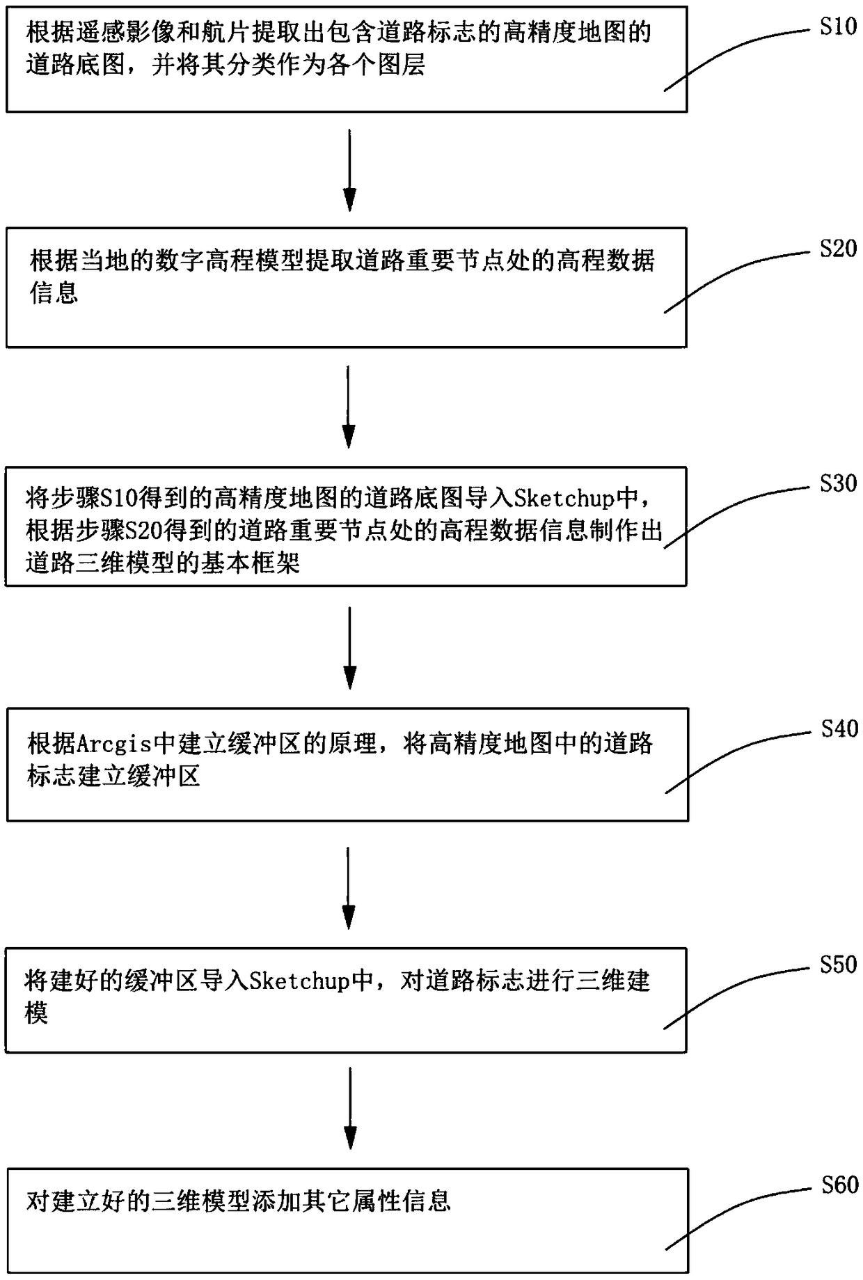
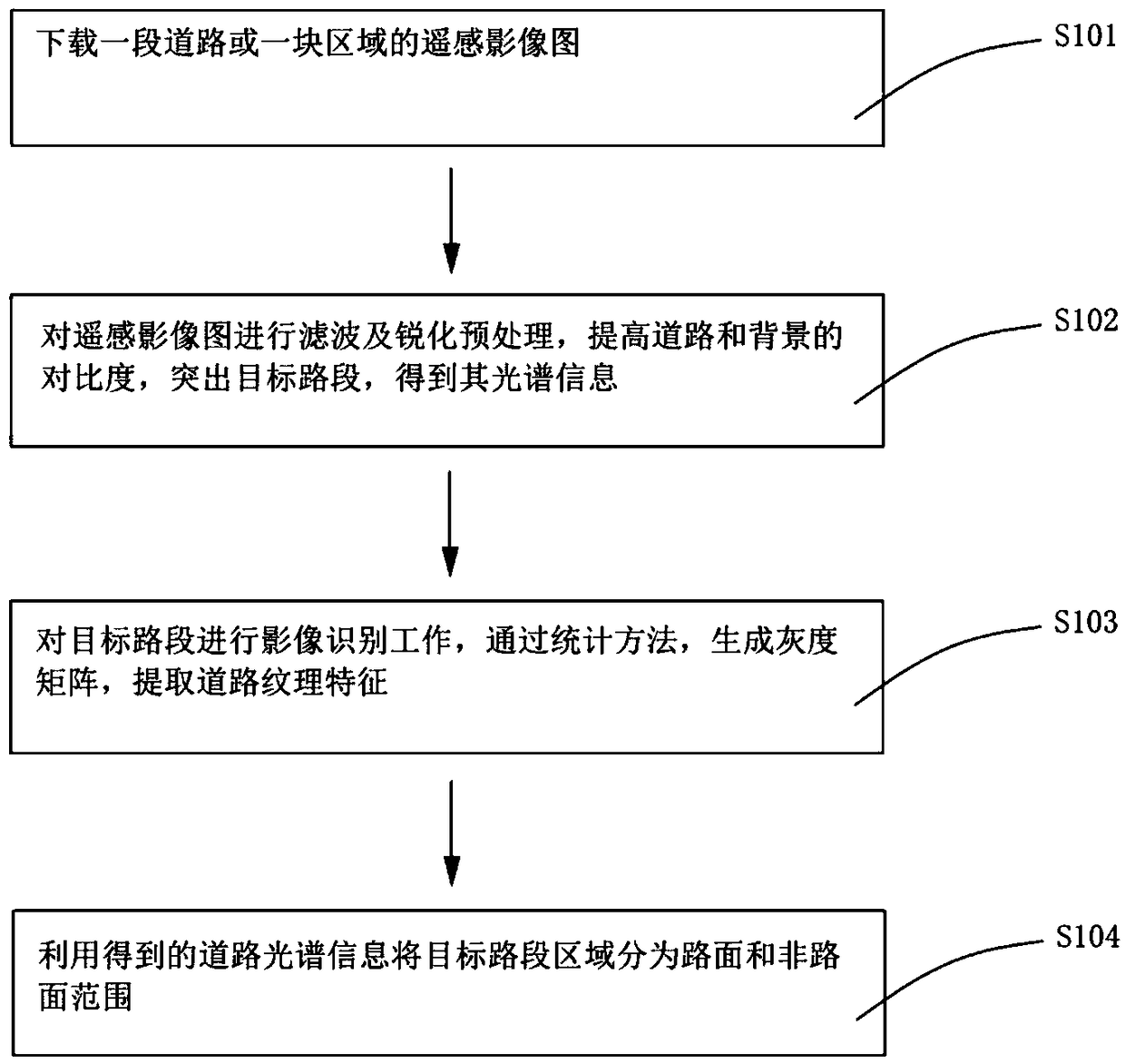
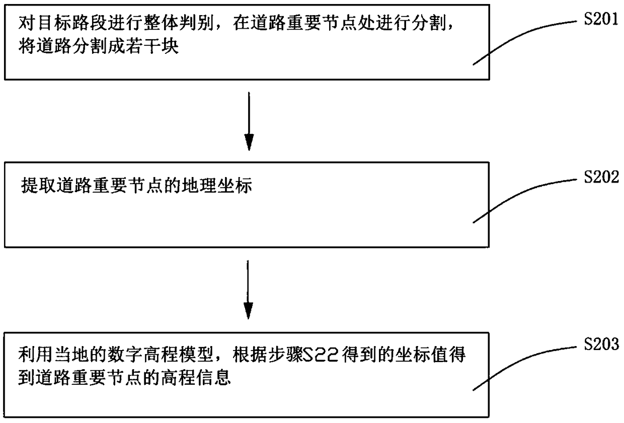
[0049] The following will clearly and completely describe the technical solutions in the embodiments of the present invention with reference to the accompanying drawings in the embodiments of the present invention. Obviously, the described embodiments are only a part of the embodiments of the present invention, not all the embodiments. . Based on the embodiments of the present invention, all other embodiments obtained by those of ordinary skill in the art without creative work shall fall within the protection scope of the present invention.

[0050] It should be noted that the terms used in the embodiments of the present invention are only for the purpose of describing specific embodiments, and are not intended to limit the present invention. The singular forms of "a", "said" and "the" used in the embodiments of the present invention and the appended claims are also intended to include plural forms, unless the context clearly indicates other meanings. It should also be understoo...


PUM


Abstract

The invention provides a road three-dimensional model modeling method based on a lane-level high-precision map. The method comprises the steps of S10, extracting road base drawings of the high-precision map according to a remote sensing image and an aerial photo, and classifying the road base drawings to serve as graphic layers; S20, extracting elevation data information at important road nodes according to a local digital elevation model; S30, importing the road base drawings of the high-precision map into Sketchup, and making a basic framework of a road three-dimensional model according to the elevation data information at the important road nodes; S40, establishing a buffer area for road signs in the high-precision map; S50, importing the established buffer area into the Sketchup, and performing three-dimensional modeling on the road signs; and S60, adding other attribute information to the built three-dimensional model. According to the method, the remote sensing image, actual aerially photographed road information and terrain information reflected by the digital elevation model are effectively combined, so that real road information can be reflected; and the three-dimensionalmodel conforms to visual habits of a driver, so that driving navigation can be effectively realized.

Description

【Technical Field】 [0001] The invention relates to the technical field of road three-dimensional modeling, in particular to a road three-dimensional model modeling method based on a lane-level high-precision map. 【Background technique】 [0002] With the development of GIS technology, computer technology and network technology, the realization of spatial digitization and virtualization to establish digital geographic space has become an important means for countries in the world to grasp the trend of high-tech and promote economic development, represented by digital cities and digital earth. The digital geographic space plays an important role in land use supervision, spatial information management, urban system planning and management. The foundation of digital geospatial establishment is the establishment of a three-dimensional model of geographic data. The spatial data of road sections obtained by surveying and mapping methods basically belong to 2D or 2.5D structure, which onl...

Claims


Application Information

Patent Timeline
IPC IPC(8): G06T17/05
CPCG06T17/05G06T2207/30256
Inventor 颉刚刘振宇李昱吴金恒
Owner 广东星舆科技有限公司
Why Eureka
Try Eureka