
GNSS monitoring data processing method based on inclination sensing

A technology of monitoring data and processing method, which is applied in the field of GNSS monitoring data processing based on inclination sensing, can solve the problem of inconsistency between the real deformation vector and the data representation vector, and achieve the effect of improving observation accuracy and reliability

Inactive Publication Date: 2019-01-04
CHONGQING INST OF GEOLOGY & MINERAL RESOURCES +1
View PDF2 Cites 10 Cited by
  • Summary
  • Abstract
  • Description
  • Claims
  • Application Information

AI Technical Summary

Problems solved by technology

[0005] In view of the above-mentioned deficiencies existing in the prior art, the purpose of the present invention is to: provide an analysis method capable of effectively analyzing surface deformation monitoring data, which can solve the problem that the real deformation vector does not match the data representation vector in the GNSS displacement monitoring process, and has the ability to monitor Reliable data, improved observation accuracy, simple monitoring data analysis and intuitive characterization results, etc.

Method used


Image

  • GNSS monitoring data processing method based on inclination sensing
  • GNSS monitoring data processing method based on inclination sensing
  • GNSS monitoring data processing method based on inclination sensing

Examples


Embodiment

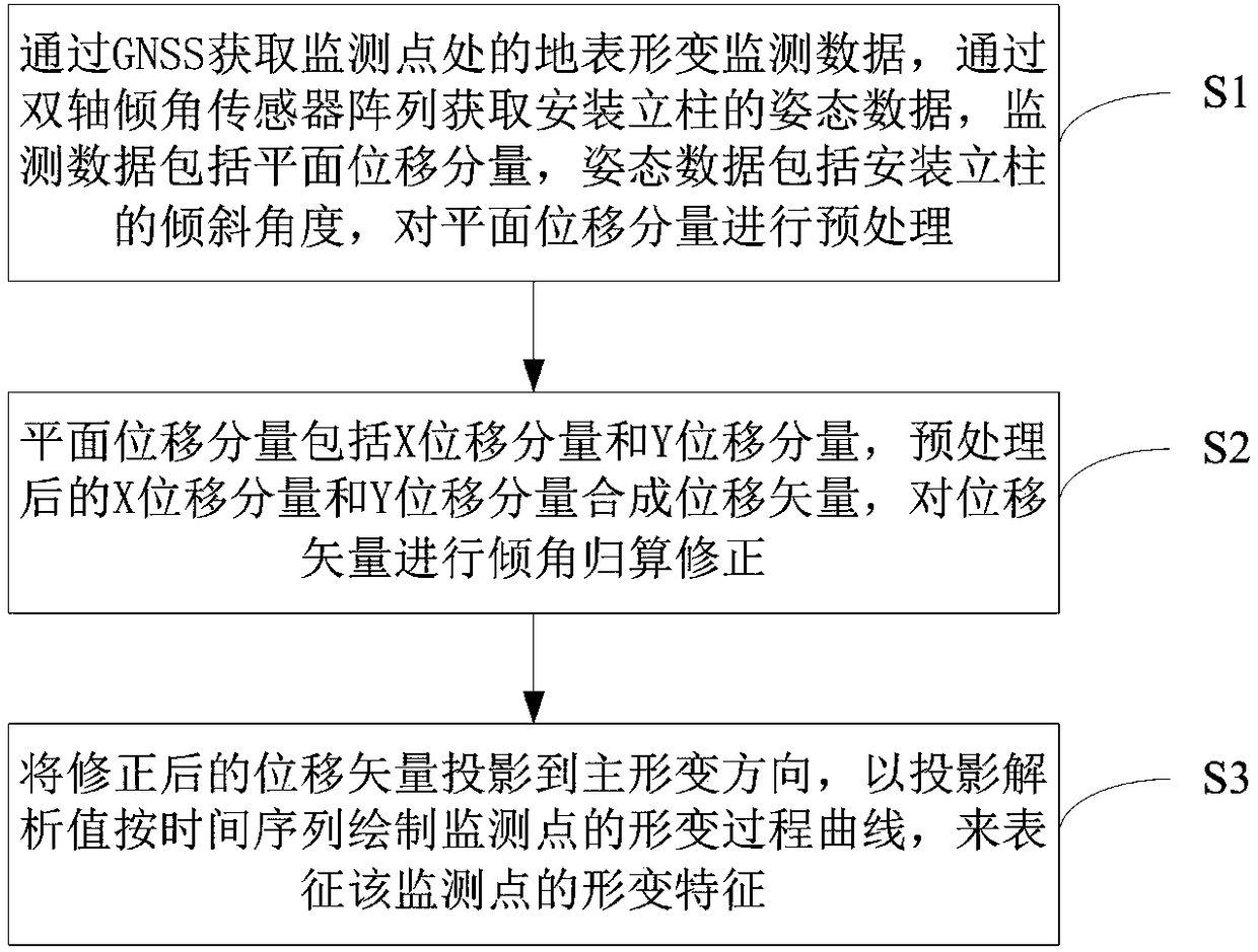
[0050] refer to figure 1 , a kind of GNSS monitoring data processing method based on inclination sensing, the method comprises the following steps:

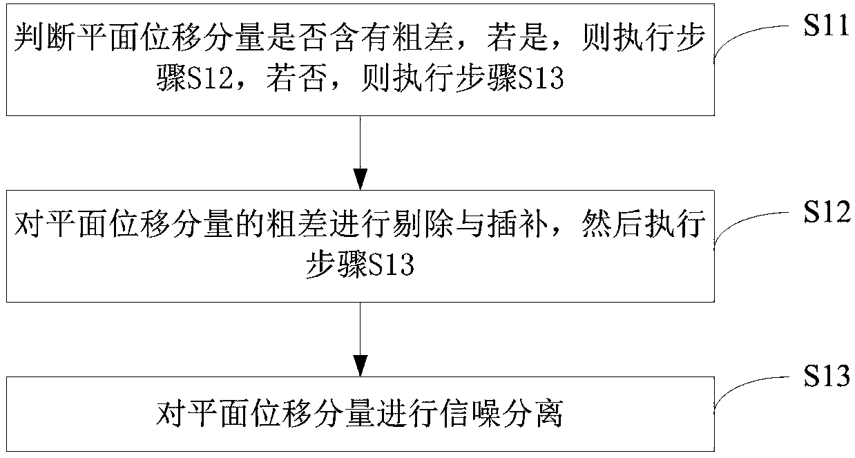
[0051] S1: Obtain the surface deformation monitoring data at the monitoring point through the global satellite navigation and positioning system GNSS, and obtain the attitude data of the installation column through the dual-axis inclination sensor array. The monitoring data includes the center plane displacement component of the GNSS monitoring equipment, and the attitude data includes the inclination of the installation column Angle, to preprocess the plane displacement component;

[0052] S2: The plane displacement component includes an X displacement component and a Y displacement component, and the preprocessed X displacement component and Y displacement component synthesize a displacement vector, and perform inclination correction on the displacement vector;

[0053] S3: When the main deformation direction of the monitorin...


PUM


Abstract

The invention discloses a GNSS monitoring data processing method based on inclination sensing, and the method comprises the following steps: S1, acquiring a central plane displacement component of a GNSS monitoring device at a monitoring point by GNSS, acquiring the installation tilt angle of a vertical column by a dual-axis tilt sensor array, and preprocessing the plane displacement component; S2, synthesizing the preprocessed X displacement component and the preprocessed Y displacement component to form a displacement vector, and performing the inclination correction of the displacement vector, wherein the plane displacement component includes the X displacement component and the Y displacement component; S3, projecting the corrected displacement vector to a main deformation direction when the main deformation direction of the monitoring point is known, drawing a deformation process curve of the monitoring point according to the time sequence by the projection analytical value so asto represent the deformation characteristic of the monitoring point. The method solves a problem that a real deformation vector is not matched with the data representation vector in the GNSS displacement monitoring process, is reliable in monitoring data, is high in observation precision, is simple and convenient in data analysis, and is visual in characterization result.

Description

technical field [0001] The invention relates to the field of ground deformation monitoring, in particular to a method for processing GNSS monitoring data based on inclination angle sensing. Background technique [0002] The global navigation satellite system, or GNSS for short, currently mainly includes GPS in the United States, GLONAS in Russia, COMPASS in China, and GALILEO in the European Union. GNSS can provide different users with dynamic three-dimensional positions at any time and at any position, and has been widely used in geodetic inspection, precision engineering measurement, deformation monitoring and other fields. [0003] At present, when monitoring the deformation of geological disasters such as landslides, it is mainly to observe the change of a series of factors over time, such as surface displacement characteristics, rainfall, groundwater level, etc. Among them, the results of displacement monitoring are intuitive and effective, and are the most important. ...

Claims


Application Information

Patent Timeline
IPC IPC(8): G01B7/16
CPCG01B7/16
Inventor 魏世玉陈立川陈柏林吴孟何飞胡祝敏李川徐洪李辉李超谢行
Owner CHONGQING INST OF GEOLOGY & MINERAL RESOURCES
Learn More