Geographical monitoring platform and implementation method for wireless network optimization analysis

A technology of wireless network optimization and monitoring platform, applied in wireless communication, data exchange network, electrical digital data processing, etc., to achieve the effect of improving accuracy, work operability, and improving analysis efficiency

Active Publication Date: 2019-01-08
湖南华诺科技有限公司
View PDF6 Cites 5 Cited by
  • Summary
  • Abstract
  • Description
  • Claims
  • Application Information

AI Technical Summary

Problems solved by technology

[0010] The purpose of the present invention is to provide a geographical monitoring platform and implementation method for wireless network optimization analysis, thereby solving the aforementioned problems in the prior art

Method used


Image

  • Geographical monitoring platform and implementation method for wireless network optimization analysis
  • Geographical monitoring platform and implementation method for wireless network optimization analysis
  • Geographical monitoring platform and implementation method for wireless network optimization analysis

Examples


Embodiment 1

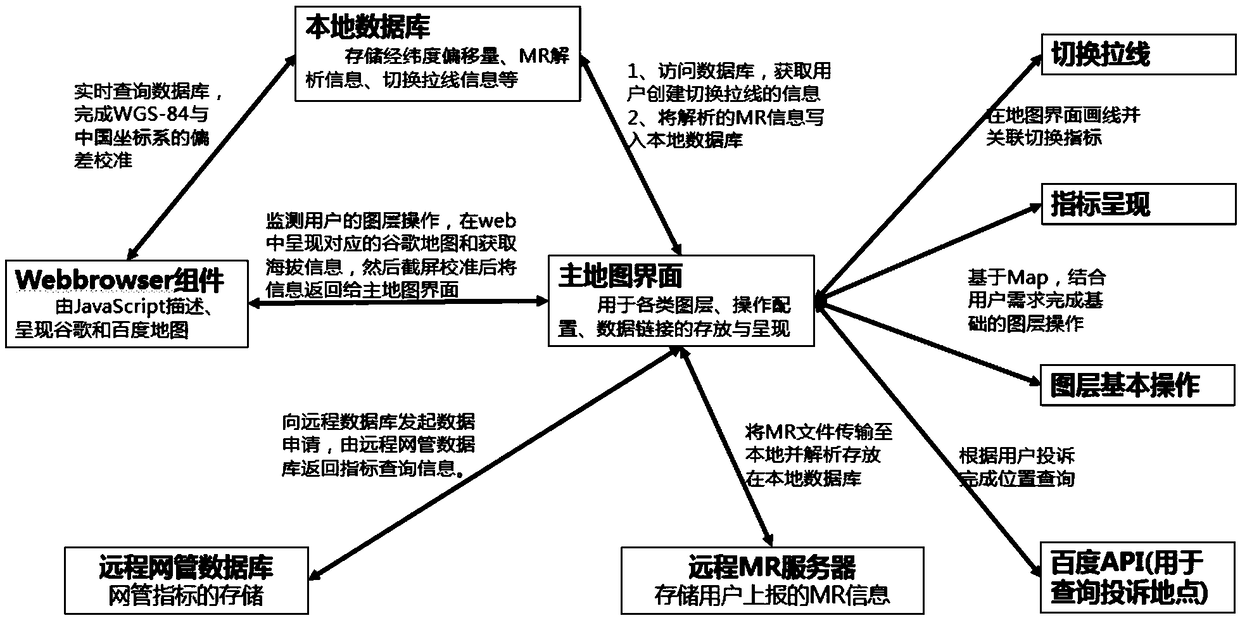
[0056] like figure 1 As shown, the embodiment of the present invention provides a geographical monitoring platform for wireless network optimization analysis, including:

[0057] The main map module is used for map development with general map components as the main body, providing users with the presentation of data layers, information query and functional operations of thematic layers;

[0058] The real-time geographical presentation module is used to construct a corresponding online map in real time according to the obtained map information queried by the user, intercept the geographical picture photo presented by the online map, and embed the photo into the bottom layer of the main interface of the map queried by the user;

[0059] The geographic indicator display module is used to transfer the geographic indicator data queried from the remote network management database to the main map module in the form of an array, and is also used to present it in the form of a themati...

Embodiment 2

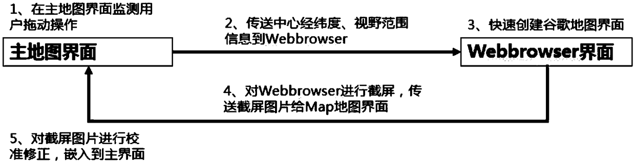
[0068] like image 3 As shown, the embodiment of the present invention provides an implementation method of a geographic monitoring platform for wireless network optimization analysis, including a real-time presentation method of geographical images, which can be implemented according to the following method:

[0069] A1, monitor the user's dragging operation on the map in real time, obtain the longitude and latitude of the center of the final location of the map after the user completes the dragging operation, and the field of view presented by the map. The field of view is the upper left, lower left, and upper right of the map interface and the latitude and longitude of the lower right fixed point;

[0070] A2. According to the obtained data of the center's latitude and longitude and field of view, construct an online map corresponding to it in real time, and present the geographical appearance under the center's latitude and longitude and field of view on the online map;

...


PUM


Abstract

The invention discloses a geographic monitoring platform and an implementation method for wireless network optimization analysis, which relates to the technical field of wireless network communication. By realizing the real-time embedding of geosatellite image on the map, the method simplifies the analysis work combined with geography and improves the analysis efficiency of field workers. Throughthe presentation of geographic indicators, the indicators can indicate the location of information, field personnel can quickly locate the area of communication failure. By creating switching cable based on geographic map, users can change the monotonous and complex form of table, and make the analysis of switching problems more intuitive and efficient. Therefore, adopting the monitoring platformand the realization method provided by the invention, in the wireless network optimization work, the user can finish the quick presentation and analysis positioning of various index problems based onthe geographic information, so as to improve the accuracy of analysis and the operability of work.

Description

technical field [0001] The invention relates to the technical field of wireless network communication, in particular to a geographical monitoring platform and an implementation method for wireless network optimization analysis. Background technique [0002] Wireless network optimization is to analyze the traffic data of the existing network, use road test, parameter verification, hardware monitoring and other means to find out the reasons that affect the quality of the network, and through the modification of parameters, network structure or equipment configuration Adjust and adopt certain technical means (using MRP planning methods, etc.) to ensure the high-quality operation of the system, so that the existing network resources can obtain the best benefits, and obtain the maximum benefits with the most economical investment. [0003] At present, many tasks in wireless network optimization analysis need to be combined with geographic maps for indicator presentation and analy...

Claims


Application Information

Patent Timeline
Patent Type & Authority Applications(China)
IPC IPC(8): H04L12/24H04W64/00G06F16/00
CPCH04L41/0823H04L41/22H04W64/00
Inventor 唐梓秦
Owner 湖南华诺科技有限公司
Why Eureka
Try Eureka