Flight navigation method and device and unmanned aerial vehicle

A navigation method and flight position technology, applied in the field of unmanned aerial vehicles, can solve the problems of easy deviation from the flight route and low accuracy of unmanned aerial vehicles

Inactive Publication Date: 2019-02-05
GUANGZHOU XAIRCRAFT TECH CO LTD
View PDF4 Cites 10 Cited by
  • Summary
  • Abstract
  • Description
  • Claims
  • Application Information

AI Technical Summary

Problems solved by technology

[0008] Embodiments of the present invention propose a flight navigation method, device, and unmanned aerial vehicle to solve the prob

Method used


Image

  • Flight navigation method and device and unmanned aerial vehicle
  • Flight navigation method and device and unmanned aerial vehicle
  • Flight navigation method and device and unmanned aerial vehicle

Examples


Embodiment Construction

[0114] In order to make the above objects, features and advantages of the present invention more comprehensible, the present invention will be further described in detail below in conjunction with the accompanying drawings and specific embodiments.

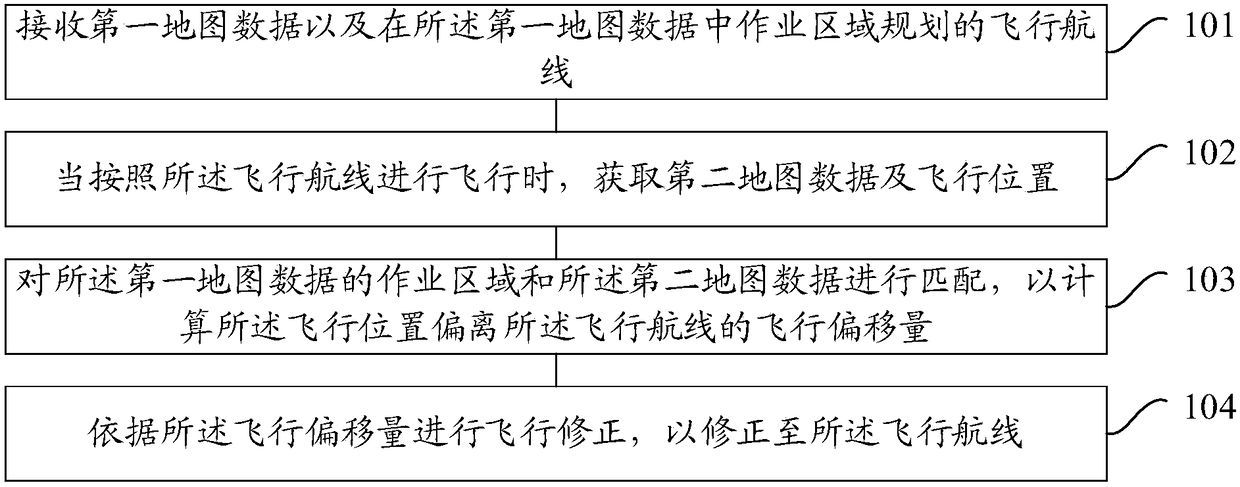
[0115] refer to figure 1 , which shows a flow chart of steps of a flight navigation method according to an embodiment of the present invention, which may specifically include the following steps:

[0116] Step 101, receiving first map data and a flight route planned for an operation area in the first map data.

[0117] In a specific implementation, the embodiments of the present invention can be applied to unmanned aerial vehicles, which refer to aircrafts that use wireless remote control or program control to perform specific aviation tasks, such as agricultural plant protection, camera, logistics, and so on.

[0118] Applying the embodiment of the present invention, the first map data can be pre-collected. The first map data is...


PUM


Abstract

The embodiment of the invention provides a flight navigation method and device and unmanned aerial vehicle. The flight navigation method is applied to the unmanned aerial vehicle and comprises the steps that first map data and a flight route planned in an operation area in the first map data are obtained; when the unmanned aerial vehicle flies according to the flight route, second map data and theflight position are obtained; the operation area of the first map data is matched with the second map data, so that the flight offset of the flight position deviating from the flight route is calculated; and flight correction is conducted according to the flight offset, and thus the flight position is corrected to the flight route. Deviation brought by positioning in the mode of GPS and the likeis corrected through the relationship between the two map data, the positioning accuracy is improved, the robustness of a system in the unmanned aerial vehicle is improved, thus the probability of deviating from the flight route during flying is decreased, and normal executing of the flight task is ensured.

Description

technical field [0001] The invention relates to the technical field of unmanned aerial vehicle, in particular to a flight navigation method, device and unmanned aerial vehicle. Background technique [0002] With the rapid development of unmanned aerial vehicles, unmanned aerial vehicles are widely used in agricultural plant protection, photography, logistics and other fields. [0003] After planning the flight route, the unmanned aerial vehicle flies according to the flight route and performs corresponding flight tasks. [0004] When flying, the unmanned aerial vehicle generally relies on GPS (Global Positioning System, Global Positioning System) for positioning and navigation. If it deviates from the flight route, it will correct the flight and return to the flight route. [0005] However, there is an error of about two meters in GPS positioning, and the accuracy is low, which makes it easy to deviate from the flight route during flight, which has a negative impact on the ...

Claims


Application Information

Patent Timeline
IPC IPC(8): G01C21/20G06Q10/04
CPCG01C21/20G06Q10/047
Inventor 刘鹏
Owner GUANGZHOU XAIRCRAFT TECH CO LTD
Why Eureka
Try Eureka