
method and a device for improving the rendering efficiency of GIS point data at a browser end

A browser and point data technology, applied in the field of GIS point data rendering, can solve the problems of not supporting other point data formats, low efficiency of GIS point data, difficulty in migration, etc., and achieve the effect of real-time rendering

Active Publication Date: 2019-02-26
BEIJING SUPERMAP SOFTWARE CO LTD
View PDF12 Cites 3 Cited by
  • Summary
  • Abstract
  • Description
  • Claims
  • Application Information

AI Technical Summary

Problems solved by technology

[0007] This application provides a method and device for improving the efficiency of browser-side GIS point data rendering, which is used to solve the problem of using a unique spatial database to store data in the prior art, which is difficult to migrate and does not support other point data formats, and a large number of browser-side rendering The problem of low efficiency when GIS point data

Method used


Image

  • method and a device for improving the rendering efficiency of GIS point data at a browser end
  • method and a device for improving the rendering efficiency of GIS point data at a browser end
  • method and a device for improving the rendering efficiency of GIS point data at a browser end

Examples


Embodiment Construction

[0054] In order to make the above objects, features and advantages of the present application more obvious and understandable, the present application will be further described in detail below in conjunction with the accompanying drawings and specific implementation methods.

[0055] In the description of the present application, it should be understood that the terms "first" and "second" are used for description purposes only, and cannot be interpreted as indicating or implying relative importance or implicitly indicating the quantity of indicated technical features. Thus, a feature defined as "first" and "second" may explicitly or implicitly include one or more of these features. "Plurality" means two or more, unless otherwise clearly and specifically defined. The terms "including", "comprising" and similar terms should be understood as open-ended terms, ie "including / comprising but not limited to". The term "based on" is "based at least in part on". The term "an embodimen...


PUM


Abstract

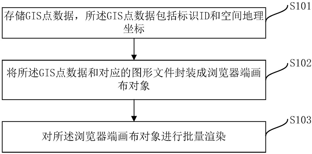
The invention provides a method and a device for improving the rendering efficiency of GIS point data at a browser end, which is characterized in that: the GIS point data is stored, and the GIS pointdata comprises an identification ID and a spatial geographic coordinate; Encapsulating the GIS point data and the corresponding graphic file into a browser end canvas object; A batch render is carriedout on that canvas object at the browser end. The present application supports GIS point data stored in common databases such as SQL Server, Oracle, Damon, Kanakura, GeoPackage, UDB, Excel, CSV, etc., and realizes real-time rendering of a large amount of GIS point data at the browser side.

Description

technical field [0001] The present application relates to the technical field of GIS point data rendering, in particular, to a method and device for improving the efficiency of browser-side GIS point data rendering. Background technique [0002] Geographic Information System (GIS) is a computer system that collects, stores, manages, processes, analyzes, displays and applies geographic data. [0003] The browser-side canvas object is an Html5 element that draws graphics through a scripting computer language. It is usually called a canvas object and is used to render graphics on the browser side. [0004] Point data is a set of discrete spatial points with geographic coordinate information consisting of one or more pairs of (X, Y) coordinates. [0005] The existing browser-side GIS point data rendering adopts the technical solution of OpenLayers: (1) enter the GIS point data with coordinate information according to the data organization method; (2) obtain the coordinate infor...

Claims


Application Information

Patent Timeline
Patent Type & Authority Applications(China)
IPC IPC(8): G06F16/29G06T11/00
CPCG06T11/00
Inventor 钟耳顺胡中南饶庆云周旭金建波苏乐乐周强张超王孟毅严结耀余志尧
Owner BEIJING SUPERMAP SOFTWARE CO LTD
Learn More