Method and system for automatically partitioning urban spatial form

A technology of spatial form and automatic zoning, applied in instruments, data processing applications, forecasting, etc., can solve the problems of low work efficiency, random technical results, inability to take into account the three-dimensional integrity of urban spatial form, etc., to avoid randomness. Effect

Inactive Publication Date: 2019-03-19
SOUTHEAST UNIV
View PDF5 Cites 12 Cited by
  • Summary
  • Abstract
  • Description
  • Claims
  • Application Information

AI Technical Summary

Problems solved by technology

Such zoning has the problems of being unable to take into account the three-dimensional integrity of urban spatial form, determining the index interval involves human brain judgment, technical results are largely random, and work efficiency is low.

Method used


Image

  • Method and system for automatically partitioning urban spatial form
  • Method and system for automatically partitioning urban spatial form
  • Method and system for automatically partitioning urban spatial form

Examples


Embodiment Construction

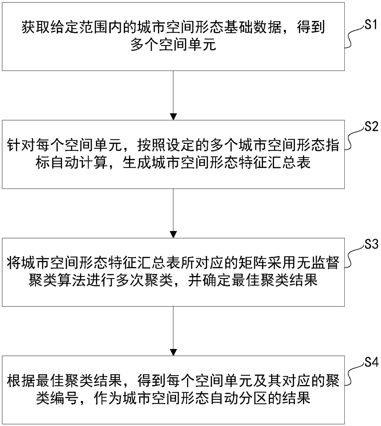
[0031] The technical solution of the present invention will be described in further detail below in conjunction with the accompanying drawings and embodiments.

[0032] like figure 1 As shown, the embodiment of the present invention discloses a method for automatic partitioning of urban spatial form, which mainly includes the following steps:

[0033] S1: Obtain the basic data of urban spatial form within a given range, and obtain several spatial units as the basis of the partition algorithm from the basic data.

[0034]In this step, the basic database of urban spatial form can be obtained through government departments or other data providing platforms. The basic database includes a number of spatial units according to blocks, land use or property rights; the map or image data can also be processed by geographic information processing software Processing, combined with the basic data of urban buildings to process and obtain by itself. The spatial unit is usually a block (th...


PUM


Abstract

The invention discloses a method and a system for automatically partitioning urban spatial form. The method comprises the following steps: acquiring basic data of urban spatial form within a given range, and obtaining a plurality of spatial units; for each spatial unit, a summary table of urban spatial morphological characteristics is generated automatically according to the set urban spatial morphological indexes. The matrix corresponding to the summary table of urban spatial morphology features is clustered by unsupervised clustering algorithm. In the clustering process, different clusteringparameters are set to cluster several times, and the clustering results are scored to determine the best clustering results. According to the best clustering result, the result of automatic partitionof urban spatial morphology is obtained. Furthermore, the correlation between the indicators can be analyzed and the key impact indicators can be obtained. The invention can objectively and comprehensively understand the characteristics of the urban spatial form, thereby forming the result of the automatic zoning and the key influence index, and avoiding the problems of subjective judgment or single dimension of inspection and the like that easily occur in the traditional method.

Description

technical field [0001] The invention belongs to the field of urban planning, and relates to a method and system for partitioning urban spatial forms, in particular to a method and system for automatically partitioning urban spatial forms by extracting multi-dimensional morphological features of urban three-dimensional space entities. Background technique [0002] Urban spatial form is the core research object of urban planning discipline. In the process of rapid urbanization, cities are constantly "expanding" and "growing taller", and the urban spatial form has become more and more complex. Different from administrative zoning, resource zoning, ecological level zoning, etc., urban spatial morphological zoning is the division of architectural entities in the three-dimensional physical space of the city. Urban spatial form partitioning is an important link in analyzing urban spatial form. Through urban spatial form partitioning, the internal mechanism of urban spatial form ca...

Claims


Application Information

Patent Timeline
Patent Type & Authority Applications(China)
IPC IPC(8): G06Q10/04G06Q50/08
CPCG06Q10/04G06Q50/08
Inventor 杨俊宴曹俊刘志成王桥姚莉任刚刘志远崇志宏
Owner SOUTHEAST UNIV
Why Eureka
Try Eureka