Multifunctional surveying and mapping instrument
A surveying and mapping instrument, multi-functional technology, applied in the direction of surveying instruments, surveying and navigation, instruments, etc., can solve the problems of tripods that require a lot of effort, fixed to the dirt ground, etc.
- Summary
- Abstract
- Description
- Claims
- Application Information
AI Technical Summary
Problems solved by technology
Method used
Image
Examples
Embodiment 1
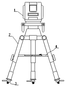
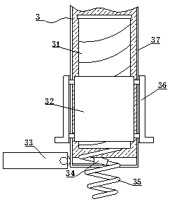
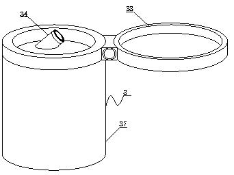
[0026] see Figure 1-7 , the present invention provides the following technical solutions: a multi-functional surveying and mapping instrument, comprising a surveying and mapping main body 1 and a surveying and mapping bracket 2 that is screwed and connected to the bottom of the surveying and mapping main body 1, the bottom of the surveying and mapping bracket 2 is connected with a leg assembly 3, and the leg assembly 3 Including, screw mandrel 31, inner rotating sleeve 32, cleaning hole 34, supporting foot 35, outer rotating sleeve 36 and supporting leg 37, wherein, the bottom end of screw mandrel 31 is welded with supporting foot 35, and the surface of screw mandrel 31 is screwed and connected with inner The rotating sleeve 32, the inner rotating sleeve 32 is engaged with the inside of the supporting leg 37, the surface of the inner rotating sleeve 32 is welded with a fixed ring, the fixing ring penetrates the surface of the supporting leg 37 and extends to the outside of the...
PUM
 Abstract
Description
Claims
Application Information
 - R&D
- Intellectual Property
- Life Sciences
- Materials
- Tech Scout
- Unparalleled Data Quality
- Higher Quality Content
- 60% Fewer Hallucinations
Browse by: Latest US Patents, China's latest patents, Technical Efficacy Thesaurus, Application Domain, Technology Topic, Popular Technical Reports.
© 2025 PatSnap. All rights reserved.Legal|Privacy policy|Modern Slavery Act Transparency Statement|Sitemap|About US| Contact US: help@patsnap.com


