
A multifunctional surveying and mapping instrument

A surveying and mapping instrument, multi-functional technology, used in surveying instruments, surveying and navigation, instruments, etc., can solve problems such as fixing to the soil ground and taking a lot of effort to tripods

Inactive Publication Date: 2020-12-08
SHAANXI RAILWAY INST
View PDF5 Cites 3 Cited by
  • Summary
  • Abstract
  • Description
  • Claims
  • Application Information

AI Technical Summary

Problems solved by technology

[0004] When the existing multifunctional surveying and mapping instruments are in use, the surveying and mapping instruments are generally installed on the tripod for fixed surveying and mapping. Before surveying and mapping, the surveying and mapping tripod needs to be fixed. It is used to insert into the dirt ground for fixing, but in the hard and uneven dirt ground, it takes a lot of effort for the staff to fix the tripod into the dirt ground

Method used


Image

  • A multifunctional surveying and mapping instrument
  • A multifunctional surveying and mapping instrument
  • A multifunctional surveying and mapping instrument

Examples


Embodiment 1

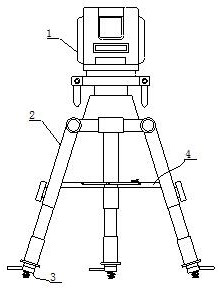
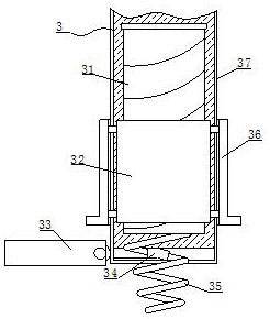
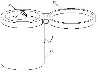
[0026] see Figure 1-7 , the present invention provides the following technical solutions: a multi-functional surveying and mapping instrument, comprising a surveying and mapping main body 1 and a surveying and mapping bracket 2 that is screwed and connected to the bottom of the surveying and mapping main body 1, the bottom of the surveying and mapping bracket 2 is connected with a leg assembly 3, and the leg assembly 3 It includes a screw mandrel 31, an inner rotating sleeve 32, a cleaning hole 34, a leg 35, an outer rotating sleeve 36 and a leg 37, wherein the bottom end of the screw mandrel 31 is welded with a leg 35, and the surface of the screw mandrel 31 is screwed and connected with an inner rotating The sleeve 32, the inner rotating sleeve 32 is engaged in the inside of the supporting leg 37, the surface of the inner rotating sleeve 32 is welded with a fixed ring, the fixing ring penetrates the surface of the supporting leg 37 and extends to the outside of the supportin...


PUM


Abstract

The invention belongs to the technical field of surveying and mapping devices, and particularly discloses a multifunctional surveying and mapping instrument. The multifunctional surveying and mappinginstrument comprises a surveying and mapping instrument main body and a surveying and mapping bracket which is in spinning connection with the bottom end of the surveying and mapping instrument main body; the bottom ends of the surveying and mapping bracket are connected with supporting leg assemblies; each supporting leg assembly comprises a screw rod, an internal rotating sleeve, a cleaning hole, a supporting foot, an external rotating sleeve and a supporting leg, wherein the bottom end of each screw rod is welded with the corresponding supporting foot; the surface of each screw rod is in spinning connection with the corresponding internal rotating sleeve; each internal rotating sleeve is clamped to the interior of the corresponding supporting leg; the surface of each internal rotating sleeve is welded with a fixed ring; the multifunctional surveying and mapping instrument is provided with the supporting leg assemblies; the internal rotating sleeves are driven to rotate by rotating the external rotating sleeves by working personnel, so that the screw rods and the internal rotating sleeves are overturned to achieve the purposes of rotating, regulating, ascending and descending thesupporting legs up and down by the screw rods; and the supporting legs are rotated and inserted into the ground, so that the problem that the multifunctional surveying and mapping instrument is inconvenient to fix in rugged hard soil is solved.

Description

technical field [0001] The invention belongs to the technical field of surveying and mapping devices, and in particular relates to a multifunctional surveying and mapping instrument. Background technique [0002] The surveying and mapping instrument is a high-tech measuring instrument integrating light, machinery and electricity. It is a surveying and mapping instrument system integrating the functions of measuring horizontal angle, vertical angle, distance and height difference. It is replaced by photoelectric scanning dial, and the manual optical micrometer reading is replaced by automatic recording and display reading, which simplifies the operation of angle measurement and avoids the occurrence of reading error. [0003] There are following problems in existing technology: [0004] When the existing multifunctional surveying and mapping instruments are in use, the surveying and mapping instruments are generally installed on the tripod for fixed surveying and mapping. Be...

Claims


Application Information

Patent Timeline
Patent Type & Authority Patents(China)
IPC IPC(8): G01C15/00
CPCG01C15/00
Inventor 刘舜刘明学张福荣吴迪
Owner SHAANXI RAILWAY INST
Learn More