Path planning method, device and mobile device

A path planning and algorithm technology, applied in measurement devices, image enhancement, instruments, etc., can solve the problems of low path planning efficiency and space waste, and achieve the effect of improving path planning efficiency, saving storage space, and high path planning efficiency.

Active Publication Date: 2019-03-29
GOERTEK INC
View PDF6 Cites 48 Cited by
  • Summary
  • Abstract
  • Description
  • Claims
  • Application Information

AI Technical Summary

Problems solved by technology

Although the grid map is easy to construct, the resolution of the grid map does not depend on th

Method used


Image

  • Path planning method, device and mobile device
  • Path planning method, device and mobile device
  • Path planning method, device and mobile device

Examples


Embodiment Construction

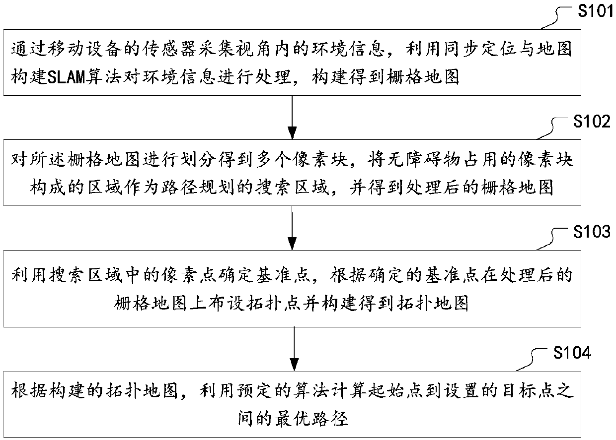
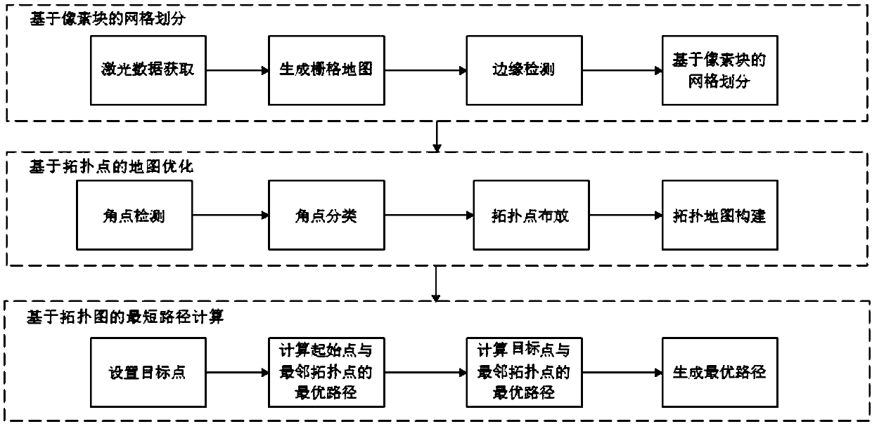
[0025] In order to make the above objects, features and advantages of the present invention more comprehensible, the present invention will be further described in detail below in conjunction with the accompanying drawings and specific embodiments. Apparently, the described embodiments are some, but not all, embodiments of the present invention. Based on the embodiments of the present invention, all other embodiments obtained by persons of ordinary skill in the art without making creative efforts belong to the protection scope of the present invention.

[0026] The design concept of the present invention is to propose a path planning scheme based on synchronous positioning and map construction, aiming at the problems of low planning efficiency and space waste in the path planning of the prior art, through grid division based on pixel blocks, topology-based The point map optimization and the shortest path calculation based on the topology map improve the path planning efficienc...


PUM


Abstract

The invention discloses a path planning method, a device and a mobile device. The method comprises: collecting environment information within the perspective by a sensor of the mobile device, using the simultaneous localization and mapping(SLAM) algorithm to process the environment information to obtain a grid map; dividing the grid map into pixel blocks, taking the area composed of the pixel blocks having no obstacles as a search area of the path planning, and obtaining a processed grid map; determining a reference point based on pixel points in the search area, arranging topological points on the processed grid map according to the determined reference point, and constructing a topological map; and calculating the optimal path between a starting point and a target point using a predetermined algorithm based on the constructed topological map. The embodiments of the invention improve the path planning efficiency and save storage resources.

Description

technical field [0001] The present invention relates to the technical field of simultaneous positioning and map construction SLAM (Simultaneous Localization AndMapping), in particular to a path planning method, device and mobile device based on simultaneous positioning and map construction. Background technique [0002] With the popularity of intelligent robots, drones, unmanned driving, virtual reality and other fields in recent years, SLAM is also well known and considered to be one of the key technologies in these fields. SLAM is a robot that starts from an unknown location in an unknown environment, locates its own position and posture by repeatedly observing map features (such as wall corners, pillars, etc.) For localization and mapping purposes. [0003] According to the different sensors used, there are three main solutions: RGB-D camera-based SLAM, vision-based SLAM, and laser sensor-based SLAM. Laser SLAM is currently a relatively mature positioning and navigation...

Claims


Application Information

Patent Timeline
IPC IPC(8): G01S17/93G01S17/89G01S17/00G01C21/20G06Q10/04G06T7/13G06T7/11G01S17/931
CPCG06Q10/047G06T7/11G06T7/13G01C21/20G01S17/006G01S17/89G01S17/93G01C21/206G01C21/005G01S17/931G01S7/4808G01S17/42G06T7/579G01C21/3807G06T2207/20164
Inventor 李保明邹李兵戴天荣
Owner GOERTEK INC
Why Eureka
Try Eureka