Supercharge Your Innovation With Domain-Expert AI Agents!

Beidou-based flight navigation system and method

A navigation system and navigation method technology, applied in the field of satellite navigation, can solve the problem of accuracy, integrity, consistency and usability to meet the requirements of PBN navigation technology, GPS navigation system stability and security cannot be guaranteed, Beidou navigation system cannot be added, etc. problems, to achieve good visualization effects, improve flight accuracy, and save flight time

Inactive Publication Date: 2019-04-02
西安索格亚航空科技有限公司 +1
View PDF9 Cites 13 Cited by
  • Summary
  • Abstract
  • Description
  • Claims
  • Application Information

AI Technical Summary

Problems solved by technology

[0005] Existing aircraft only have GPS as a satellite navigation technology, which cannot fully meet the requirements of PBN navigation technology in terms of accuracy, integrity, consistency and availability
[0006] For areas that lack road-based navigation facilities, they can only rely on GPS navigation, which has poor stability and safety performance
The stability and safety of the GPS navigation system in other parts of the world cannot be guaranteed
[0007] The existing technology cannot add the Beidou navigation system to the airborne equipment, resulting in the inability of Beidou to be applied in aviation navigation

Method used


Image

  • Beidou-based flight navigation system and method
  • Beidou-based flight navigation system and method
  • Beidou-based flight navigation system and method

Examples


Embodiment Construction

[0041] In order to make the object, technical solution and advantages of the present invention more clear, the present invention will be further described in detail below in conjunction with the examples. It should be understood that the specific embodiments described here are only used to explain the present invention, not to limit the present invention.

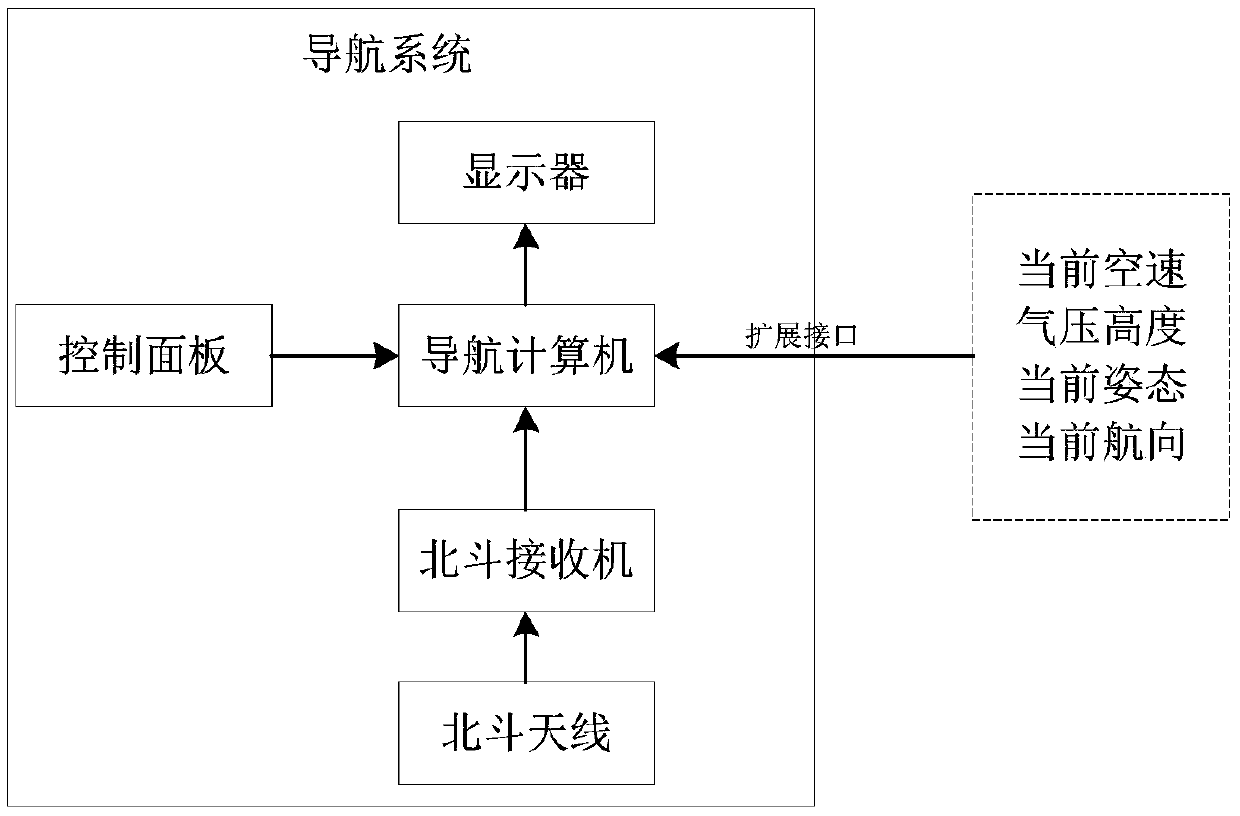
[0042] Embodiments of the present invention provide a navigation system independent of the original systems of the aircraft. The system is divided according to functional components, including navigation computer, display, control panel, Beidou receiver and Beidou antenna, such as figure 1 shown. The system can be a whole or separate components.

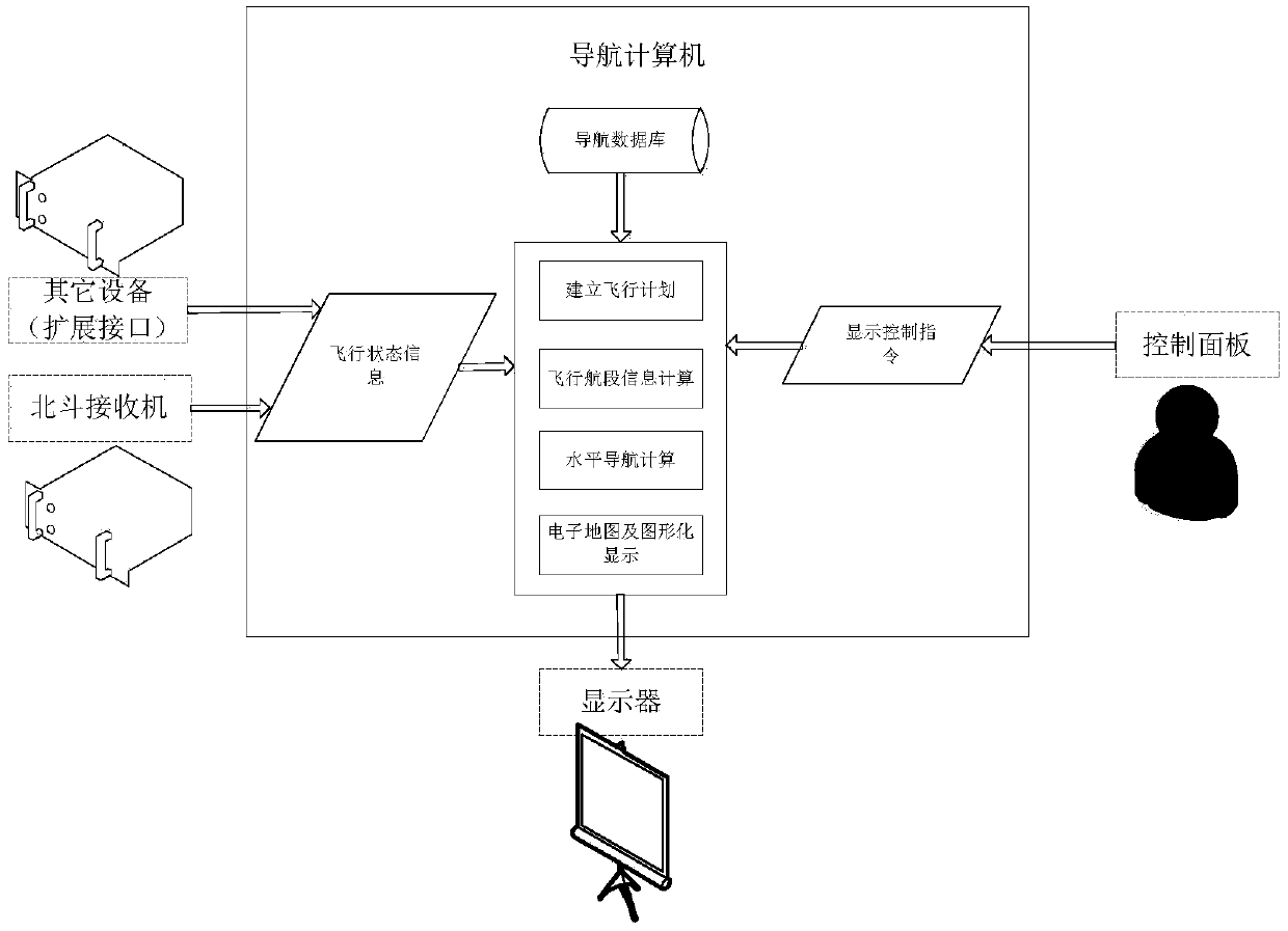
[0043] The navigation computer includes a processor, database, memory and communication interface; the navigation computer runs navigation software to complete aircraft position calculation, map generation, flight plan management, and navigation task calculation;

[0044] The c...


PUM


Abstract

The invention, which belongs to the field of satellite navigation, discloses a Beidou-based flight navigation system and method. The system comprises a navigation computer, a control panel, a displaydevice, a Beidou antenna and a Beidou receiver. The navigation computer includes a processor, a database, a memory and a communication interface. Under operation of the navigation software, aircraft position calculation, flight plan management, navigation task calculation and graphic display are completed. The display device provides functions of map interface display and flight plan management window display. The Beidou receiver receives a satellite signal through the Beidou antenna to complete position solution. According to the invention, leg information calculation and real-time navigationcalculation are performed based on an established flight plan; and a needed track angle, a distance, an azimuth angle, estimated arrival time, estimated flight time, a track angle error and horizontal deviation are calculated.

Description

technical field [0001] The invention belongs to the field of satellite navigation, in particular to a Beidou-based flight navigation system and method. Background technique [0002] At present, the existing technologies commonly used in the industry are as follows: [0003] Modern aircraft navigation is based on radio navigation equipment and GPS equipment, and navigation calculations are completed by flight management computers. For areas lacking road-based navigation facilities, only GPS navigation can be relied on. And with the development of satellite navigation technology, aircraft gradually transition to PBN navigation based on satellite navigation. However, only the GPS navigation system cannot fully meet the requirements of PBN navigation technology in terms of accuracy, integrity, consistency and availability. Moreover, the GPS navigation system is controlled by foreign countries, and its stability and safety in other parts of the world cannot be guaranteed. Wit...

Claims


Application Information

Patent Timeline
IPC IPC(8): G01S19/42
CPCG01S19/42
Inventor 郭彬任宏愿
Owner 西安索格亚航空科技有限公司
Features
  • R&D
  • Intellectual Property
  • Life Sciences
  • Materials
  • Tech Scout
  • Unparalleled Data Quality
  • Higher Quality Content
  • 60% Fewer Hallucinations
Learn More