Drone-based non-contact high slope surface displacement monitor method and monitor system

A surface displacement, non-contact technology, used in photogrammetry/video surveying, measuring devices, mapping and navigation, etc., can solve problems such as low measurement accuracy, unsafe inspectors, and low slope monitoring accuracy. , to achieve accurate measurement data and positioning, reliable calculation results, and rapid apparent displacement measurement

Inactive Publication Date: 2019-04-05
TIANJIN UNIV
View PDF6 Cites 21 Cited by
  • Summary
  • Abstract
  • Description
  • Claims
  • Application Information

AI Technical Summary

Problems solved by technology

[0004] First, the traditional monitoring method of manual inspection: it is suitable for relatively gentle slopes that are convenient for inspectors to inspect. This method consumes manpower, the accuracy of slope monitoring is very low, the detection range is limited, and the safety of inspectors is not guaranteed;
[0005] Second, the on-site measurement method of instruments such as total stations: it is suitable for the slope where it is convenient to find fixed monitoring points and easy to place monitoring instruments. This method has a large amount of work, high equipment costs, labor-intensive, low measurement accuracy, and limited monitoring range;
[0008] It can be seen that although there are many methods for slope deformation monitoring at present, each method has different defects such as consuming a lot of manpower and material resources, and the instrument is easily damaged, and there is a lack of standardization.

Method used


Image

  • Drone-based non-contact high slope surface displacement monitor method and monitor system
  • Drone-based non-contact high slope surface displacement monitor method and monitor system
  • Drone-based non-contact high slope surface displacement monitor method and monitor system

Examples


Embodiment Construction

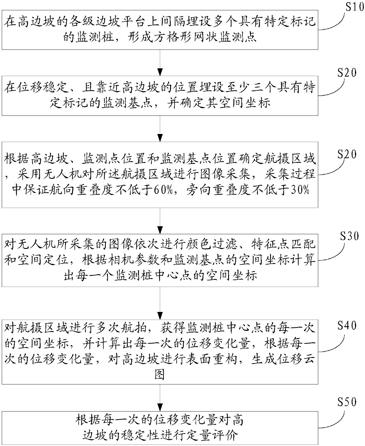
[0098] The following will clearly and completely describe the technical solutions in the embodiments of the present invention with reference to the accompanying drawings in the embodiments of the present invention. Obviously, the described embodiments are only some, not all, embodiments of the present invention. Based on the embodiments of the present invention, all other embodiments obtained by persons of ordinary skill in the art without making creative efforts belong to the protection scope of the present invention.

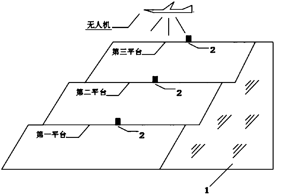
[0099] Such as figure 1 As shown, the embodiment of the present invention discloses a non-contact high slope surface displacement monitoring method based on an unmanned aerial vehicle, comprising the following steps:

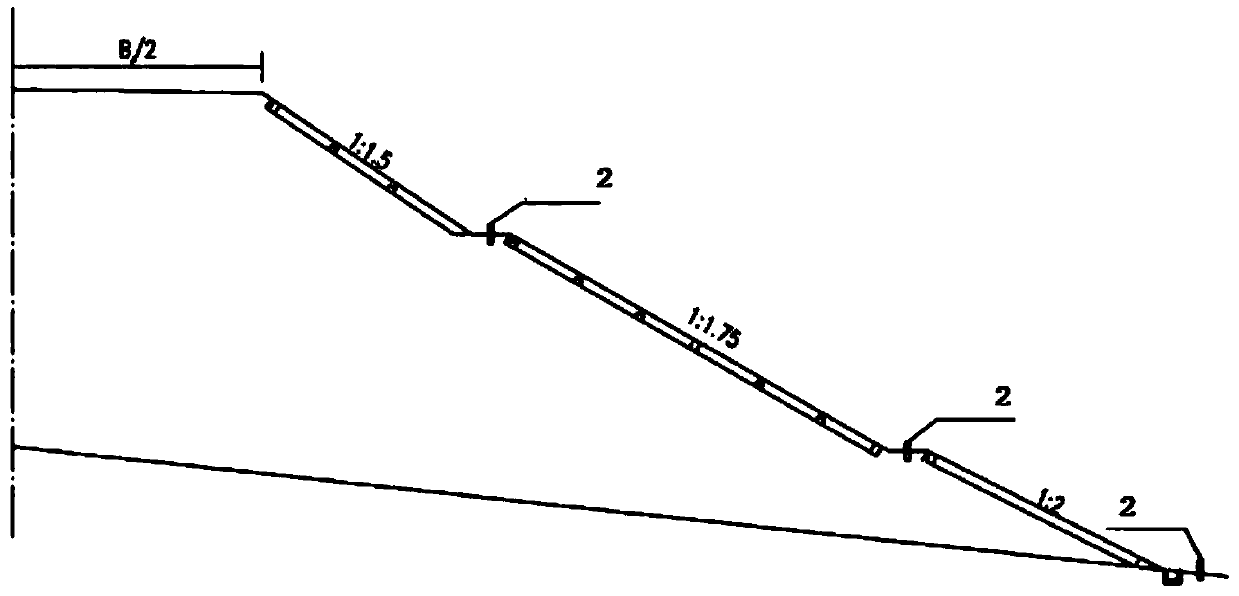
[0100] Step S10, embedding of monitoring points: burying a plurality of monitoring piles 2 with specific marks at intervals on the slope platforms of all levels of the high slope 1 to form a grid-shaped network of monitoring points;

[0101] Su...


PUM


Abstract

The invention discloses a drone-based non-contact high slope surface displacement monitor method. The method comprises following steps of: burying a monitor pile; burying a monitor base point, and determining spatial coordinates of the monitor base point; determining an aerial photographing region according to a high slope, a position of the monitor point and a position of the monitor base point,and collecting images of the aerial photographing region by using a drone; processing images collected by the drone, and calculating spatial coordinates of a center point of each monitor pile according to a camera parameter and the spatial coordinates of the monitor base point; performing aerial photographing in the aerial photographing region for many times, acquiring spatial coordinates of the center point of the monitor pile each time, calculating displacement change each time, performing surface reconstruction on the high slope according to displacement change each time, and generating a displacement cloud picture; and evaluating stability of the high slope quantitatively according to displacement change. The method improves monitor efficiency of the high slope remarkably, saves cost,and reaches monitor accuracy of a construction monitor requirement.

Description

technical field [0001] The invention relates to the technical field of high slope surface displacement monitoring, and more specifically relates to a UAV-based non-contact high slope surface displacement monitoring method and monitoring system. Background technique [0002] With the rapid development of expressways in my country and the continuous improvement of engineering construction levels, expressways can be constructed under more steep and complex terrain conditions, so it is inevitable to encounter many high slope projects during the construction process. question. The excavation of the high slope of the project will inevitably cause the deformation of the rock mass within the affected area, and the ground stress will be released and adjusted accordingly, which will have an adverse effect on the stability of the slope. The safety status of slope rock and soil is directly related to the safety of road construction. Therefore, the safety assessment and disaster warning ...

Claims


Application Information

Patent Timeline
Patent Type & Authority Applications(China)
IPC IPC(8): G01B11/03G01B11/16G01C11/00
CPCG01B11/03G01B11/16G01C11/00
Inventor 张社荣姜佩奇王超何君毅
Owner TIANJIN UNIV
Why Eureka
Try Eureka