

A Fire Detection Method Based on Multi-temporal Landsat-8 OLI Image Shortwave Infrared
A short-wave infrared, detection method technology, applied in image analysis, image enhancement, image data processing and other directions, can solve problems such as false detection
- Summary
- Abstract
- Description
- Claims
- Application Information
AI Technical Summary
Problems solved by technology
Method used
Image

Examples
Embodiment
[0043] The experimental data adopts medium-resolution Landsat-8 satellite remote sensing Level 1 (L1) product data, and the map projection is UTM-WGS84 Antarctica polar projection, all of which come from the official website of the United States Geological Survey (USGS). A total of time-phase image data before and after the fire in three research areas are included: (1) The first research area is located in Alaska, USA, known as the Anchorage Fire (Sockeye Fire, referred to as SF); (2) The second research area is Alaska, Australia. The Sampson Flat Fire (SFF for short) in Dryde; (3) The third study area is the Grampians National Park Fire (GNPF for short) in Victoria, southeastern Australia. Details are shown in Table 1.
[0044] Table 1 Introduction of Landsat-8 data used in the three fire research areas
[0045]
[0046]
[0047] Experimental results:
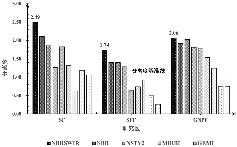
[0048] 1. Analysis of separation ability of fire and non-fire areas with different indices
[0049] Based on a certa...
PUM
 Abstract
Description
Claims
Application Information