An airport earthwork calculation method based on a digital earth

A digital earth and calculation method technology, applied in the field of regional analysis, can solve the problems of generating slopes from original terrain data, unable to analyze the site, increasing project cost and construction period, etc., to achieve the effect of improving design efficiency

Active Publication Date: 2019-04-23
西安西北民航项目管理有限公司
View PDF4 Cites 5 Cited by
  • Summary
  • Abstract
  • Description
  • Claims
  • Application Information

AI Technical Summary

Problems solved by technology

[0006](1) The workload is heavy and cumbersome. At the same time, it is often difficult to obtain 2D electronic maps in the early stage of project development, so it is impossible to Conduct a more in-depth analysis of the site;
[0007] (2) It is not convenient to intuitively perceive the economics of earthwork balance, nor can it directly use the original terrain data to generate slopes, so that the earthwork balance can only rely on experience There may be a

Method used


Image

  • An airport earthwork calculation method based on a digital earth
  • An airport earthwork calculation method based on a digital earth
  • An airport earthwork calculation method based on a digital earth

Examples


Embodiment Construction

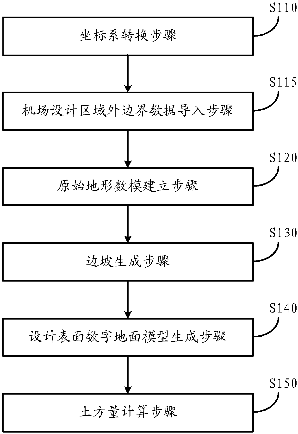
[0039] The present invention will be further described in detail below in conjunction with the accompanying drawings and embodiments. It should be understood that the specific embodiments described here are only used to explain the present invention, but not to limit the present invention. In addition, it should be noted that, for the convenience of description, only some structures related to the present invention are shown in the drawings but not all structures.

[0040] The present invention uses the digital earth to obtain the elevation of each area in real time, and completes the transformation of the airport coordinate system and the digital earth coordinate system. By digitizing the airport area defined by the user, the slope is generated according to the boundary of the design area, and the earthwork is carried out on the entire design area and the original topographic surface. Quantity calculations for quick earthwork assessments in the airport siting process.

[004...


PUM


Abstract

The invention discloses an airport earthwork calculation method based on a digital earth. The airport earthwork calculation method comprises a coordinate system conversion step S110, an original terrain digital model establishment step S120, a slope generation step S130, a surface digital ground model design generation step S140 and an earthwork amount calculation step S150. According to the invention, an online elevation and an image are used; the method can be established on an open source data earth platform OsgEarth. By digitalizing an airport area defined by a user and generating a side slope according to the boundary of the design area, the earthwork amount calculation is carried out on the whole design area and an original terrain surface, so that the earthwork amount evaluation inthe airport site selection process can be conveniently and rapidly carried out, a proper site can be initially selected, and the overall design efficiency is improved.

Description

technical field [0001] This application involves regional analysis, specifically, an airport earthwork evaluation method based on digital earth, which can perform earthwork calculation in the analysis and design of the airport in the early stage, and optimize the airport design. Background technique [0002] In recent years, with the promulgation of many favorable policies in our country, my country's general aviation industry has entered a golden period of rapid development, and various provinces and cities have successively issued their own layout plans for general airports. By 2020, the number of general-purpose airports to be built in the country will reach 500, and the construction of general-purpose airports has entered a period of rapid development. The airport configuration design and location selection are the key links in the early stage of airport construction. Whether the airport configuration design and location selection is scientific and reasonable will direct...

Claims


Application Information

Patent Timeline
IPC IPC(8): G06T17/05
CPCG06T17/05
Inventor 阮妨刘国煜良健
Owner 西安西北民航项目管理有限公司
Why Eureka
Try Eureka