
A positioning system and method for emergency networking in disaster areas

A disaster area, networking technology, applied in satellite radio beacon positioning system, radio wave measurement system, network topology and other directions, can solve the problem of unable to guarantee the quality of communication signal, unable to accurately locate rescue personnel, etc., to achieve high anti-interference ability , The effect of super wall penetration ability and high transmission rate

Active Publication Date: 2021-02-26
CHINA UNIV OF MINING & TECH
View PDF6 Cites 0 Cited by
  • Summary
  • Abstract
  • Description
  • Claims
  • Application Information

AI Technical Summary

Problems solved by technology

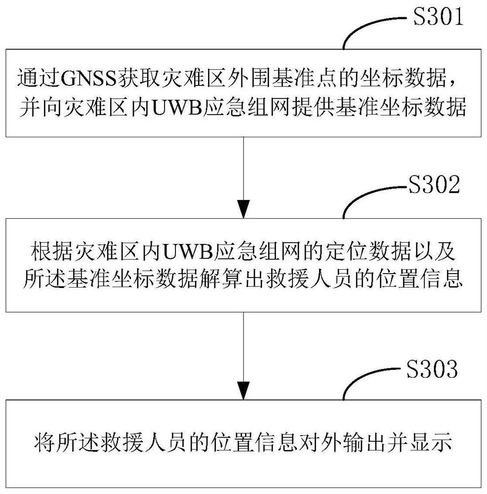
[0003] In view of the above analysis, the present invention aims to provide a positioning system and method for emergency networking in disaster areas, which effectively solves the problem that the prior art cannot guarantee the quality of communication signals at a disaster site where buildings collapse, resulting in the inability to accurately locate rescuers. question

Method used


Image

  • A positioning system and method for emergency networking in disaster areas
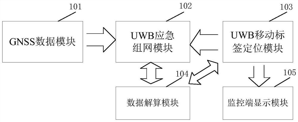
  • A positioning system and method for emergency networking in disaster areas
  • A positioning system and method for emergency networking in disaster areas

Examples


Embodiment Construction

[0021] Preferred embodiments of the present invention will be described in detail below in conjunction with the accompanying drawings, wherein the accompanying drawings constitute a part of the application and together with the embodiments of the present invention are used to explain the principle of the present invention and are not intended to limit the scope of the present invention.

[0022] The technical idea of ​​the present invention: the complex environment of the disaster site and the poor visibility make the rescue work difficult, and at the same time, because the GNSS satellite signal is difficult to guarantee the quality, the rescuers cannot accurately locate after entering the disaster area, which makes the rescue more difficult. Information on the location of rescuers inside the disaster area is not available. The present invention is based on the positioning technology combined with GNSS / UWB, and can effectively solve the problem that rescuers cannot accurately l...


PUM


Abstract

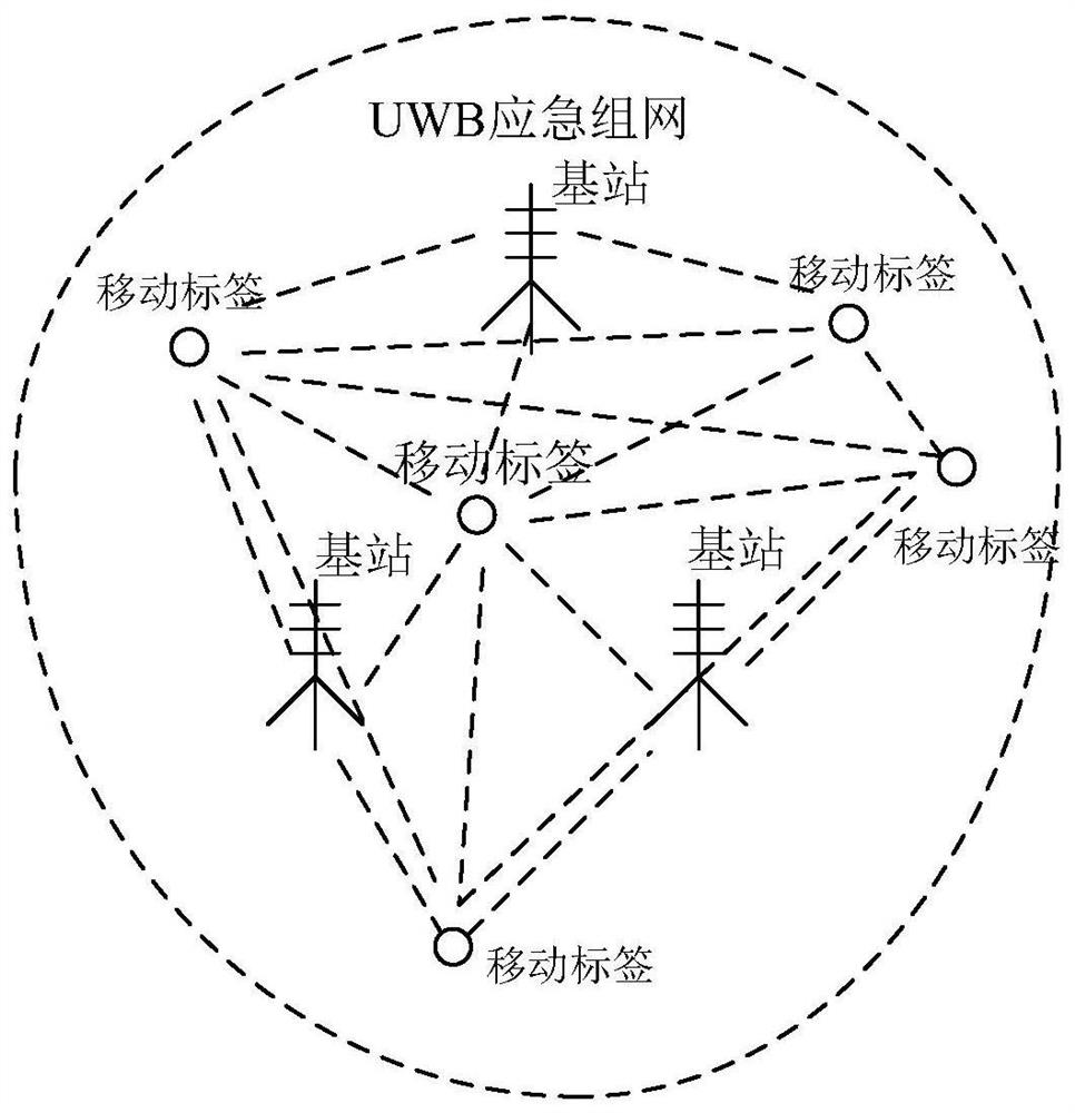
The invention relates to a disaster area emergency networking positioning system and method, and belongs to the technical field of communication positioning. The system comprises a GNSS data module which is used for obtaining coordinate data of a reference point at the periphery of a disaster area and providing the reference coordinate data for UWB emergency networking in the disaster area; The UWB emergency networking module is used for establishing UWB emergency networking in a disaster area according to the reference coordinate data; The UWB mobile tag positioning module is used for acquiring positioning data of UWB emergency networking in a disaster area; The data resolving module is used for resolving the position information of the rescuer according to the positioning data of the UWBemergency network and the reference coordinate data; And the monitoring end display module is used for receiving the position information of the rescuers and displaying the positions of the rescuersin real time. The problem that in the prior art, the quality of communication signals cannot be guaranteed on the disaster scene of building collapse, and consequently rescuers cannot be accurately positioned is solved.

Description

technical field [0001] The invention relates to the technical field of communication positioning, in particular to a UWB / GNSS-based positioning system and method for emergency networking in a building collapse transition zone at a disaster site. Background technique [0002] Earthquakes, fires, floods and other disasters are often accompanied by collapsed buildings and blocked roads. When the rescuer rescues the people in the collapsed building, it is difficult to determine the situation in the building in a short time, which delays the effective carrying out of the rescue work. At the scene of a disaster, it is difficult for the commander to rescue the trapped people within a limited time, resulting in the danger of the lives of the trapped people. The main reasons are: (1) The rescue route is not clear. The environment of the disaster scene is complex, and the visual effect is not good. It is difficult to determine the location information of the rescuers internally, whic...

Claims


Application Information

Patent Timeline
Patent Type & Authority Patents(China)
IPC IPC(8): H04W64/00H04W84/18G01S19/46
Inventor 韩厚增盛坤鹏王坚
Owner CHINA UNIV OF MINING & TECH
Learn More