Water area shoreline construction method and system based on unmanned ship

A construction method and unmanned ship technology, applied in the direction of extraction of basic elements, instrument, character and pattern recognition, etc., can solve the problem of low accuracy of shoreline in water areas

Active Publication Date: 2019-06-25
WUHAN CHUHANG SURVEYING SCI&TECH
View PDF5 Cites 8 Cited by
  • Summary
  • Abstract
  • Description
  • Claims
  • Application Information

AI Technical Summary

Problems solved by technology

[0006] In summary, the current method of constructing the

Method used


Image

  • Water area shoreline construction method and system based on unmanned ship
  • Water area shoreline construction method and system based on unmanned ship
  • Water area shoreline construction method and system based on unmanned ship

Examples


Embodiment Construction

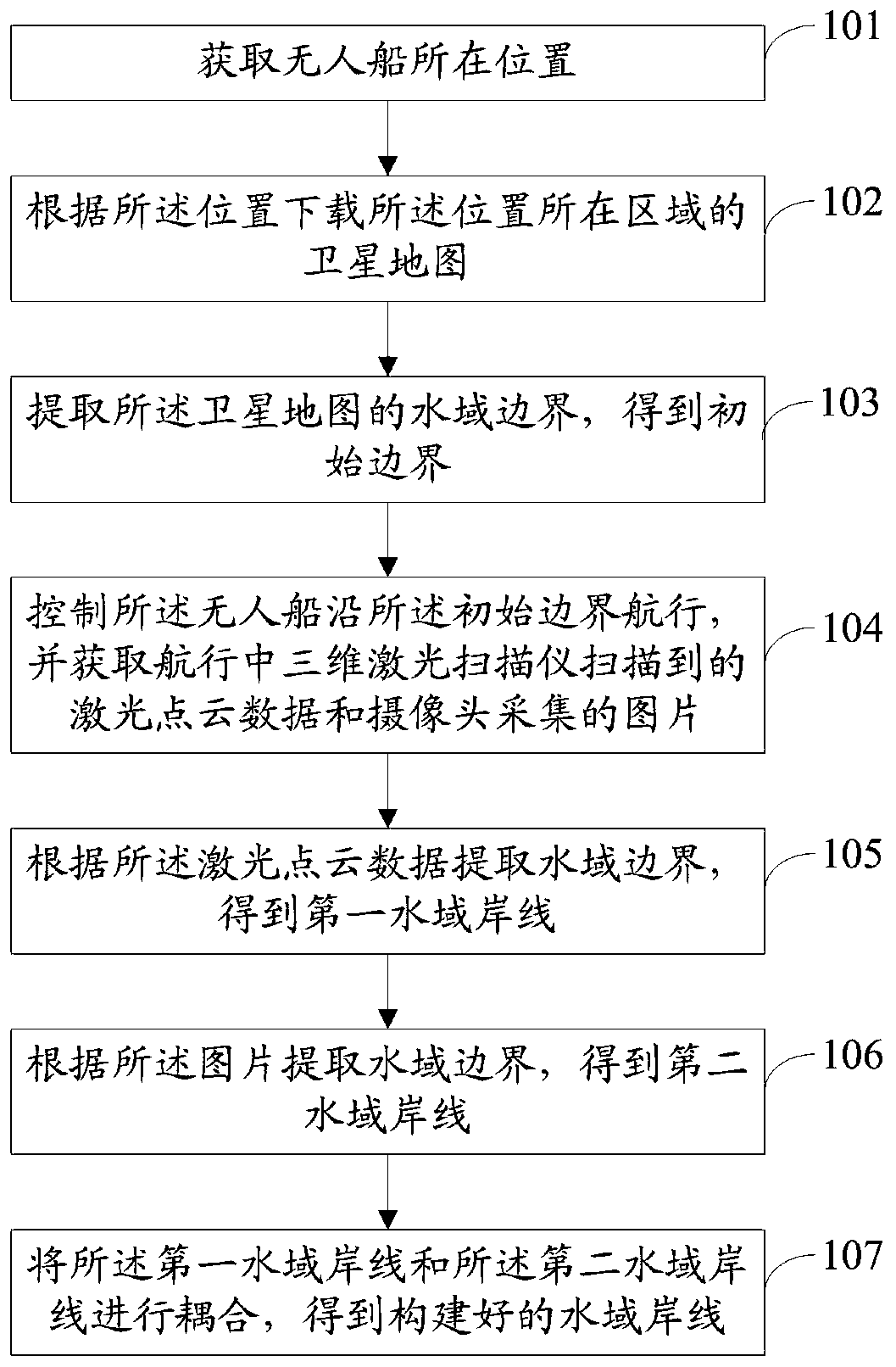
[0075] The following will clearly and completely describe the technical solutions in the embodiments of the present invention with reference to the accompanying drawings in the embodiments of the present invention. Obviously, the described embodiments are only some, not all, embodiments of the present invention. Based on the embodiments of the present invention, all other embodiments obtained by persons of ordinary skill in the art without making creative efforts belong to the protection scope of the present invention.

[0076] In order to make the above objects, features and advantages of the present invention more comprehensible, the present invention will be further described in detail below in conjunction with the accompanying drawings and specific embodiments.

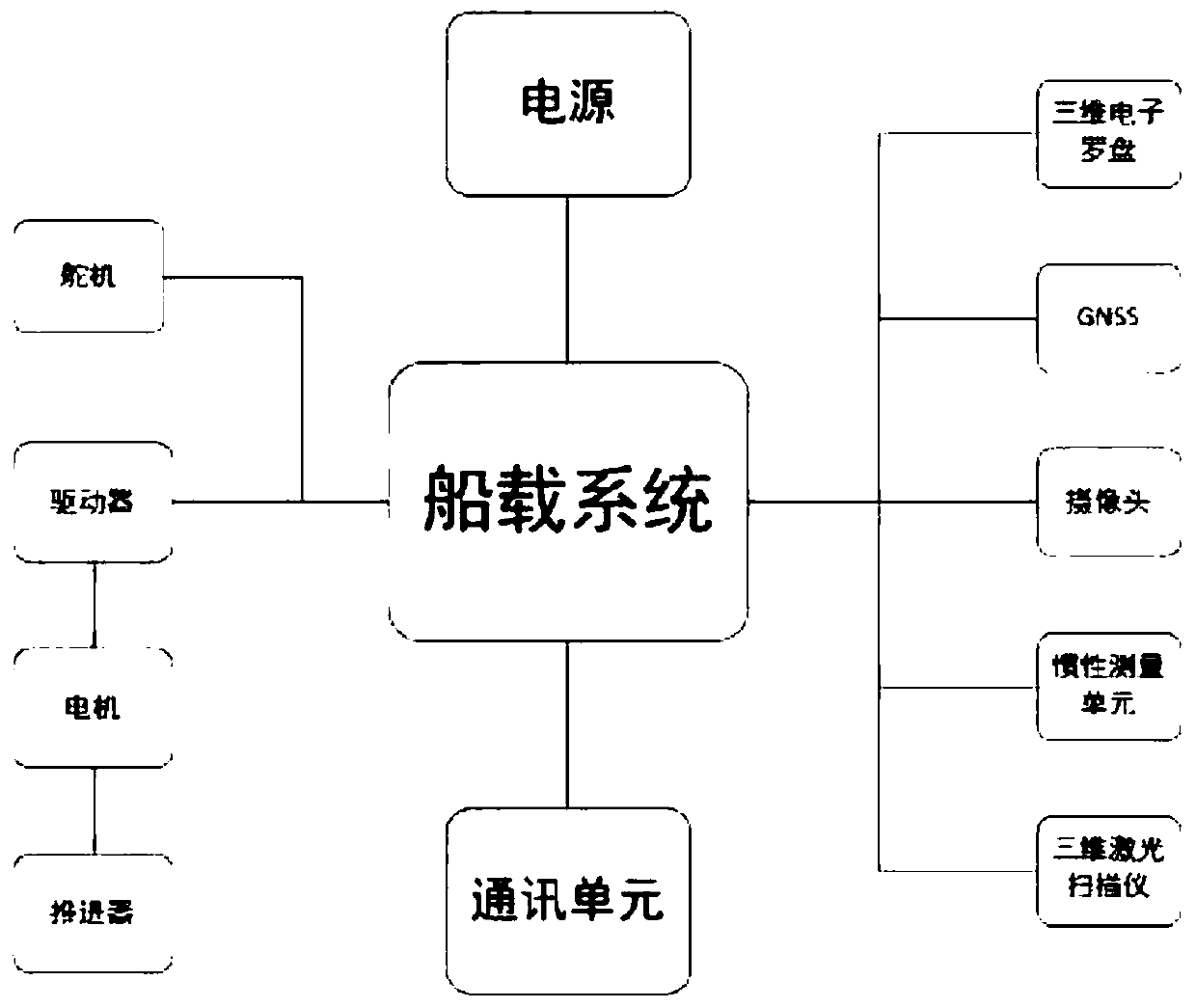
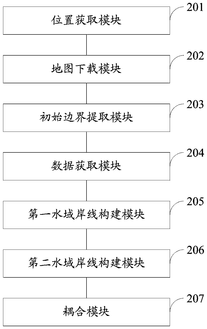
[0077] figure 1 It is a system structure diagram of the unmanned ship used in the embodiment of the method for constructing the water area shoreline based on the unmanned ship of the present invention.

[0078] s...


PUM


Abstract

The invention discloses a water area shoreline construction method and system based on an unmanned ship. The method comprises: acquiring the position of an unmanned ship; downloading a satellite map of an area where the position is located according to the position; extracting a water area boundary of the satellite map to obtain an initial boundary; controlling the unmanned ship to sail along theinitial boundary, and acquiring laser point cloud data scanned by a three-dimensional laser scanner in navigation and pictures collected by a camera; extracting a water area boundary according to thelaser point cloud data to obtain a first water area shoreline; extracting a water area boundary according to the picture to obtain a second water area shoreline; and coupling the first water area shoreline and the second water area shoreline to obtain a constructed water area shoreline. According to the unmanned ship-based water area shoreline construction method and system, the accuracy of waterarea shoreline construction can be improved.

Description

technical field [0001] The invention relates to the field of shorelines in water areas, in particular to a method and system for constructing shorelines in water areas based on unmanned ships. Background technique [0002] In the application of unmanned ships, the topography and shoreline of the water area are important basic data. Only by knowing the accurate shoreline data, the operator can design a reasonable planned route according to the actual situation. Shoreline data is also necessary data when using the collected data to accomplish industry achievements. In addition, measuring the shoreline of water areas is also an important geographic information data, and it is one of the important daily tasks of hydrology, water affairs, and land surveying and mapping departments. [0003] At present, there are two methods of constructing water coastlines: [0004] 1) Use existing data or satellite maps to outline the shoreline of the water area. However, compared with land ...

Claims


Application Information

Patent Timeline
IPC IPC(8): G06T11/20G06K9/00
Inventor 李志远李伟刘勇许建雄潘军杰肖俊
Owner WUHAN CHUHANG SURVEYING SCI&TECH
Why Eureka
Try Eureka