
A joint inversion method for aerial tem and aerial mt

A joint inversion and aeronautical technology, applied in the field of joint inversion of aeronautical TEM and aeronautical MT, can solve the problems of large resolution and unsatisfactory measurement depth

Active Publication Date: 2020-10-27
核工业航测遥感中心 +1
View PDF7 Cites 0 Cited by
  • Summary
  • Abstract
  • Description
  • Claims
  • Application Information

AI Technical Summary

Problems solved by technology

[0004] The purpose of the present invention is to provide a joint inversion method of aerial TEM and aerial MT to solve the problem that the aerial TEM or aerial MT method alone cannot meet the needs of large measurement depth and high resolution.

Method used


Image

  • A joint inversion method for aerial tem and aerial mt
  • A joint inversion method for aerial tem and aerial mt
  • A joint inversion method for aerial tem and aerial mt

Examples


Embodiment Construction

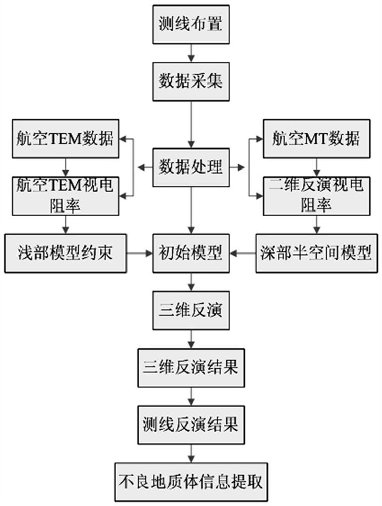
[0030] Such as figure 1 As shown, the present invention uses aviation TEM and aviation MT to measure the same area at the same time, and obtains two sets of data of aviation TEM and aviation MT through the two measurement methods, and processes the two sets of data to obtain the aerial TEM apparent resistivity section diagram respectively And the three-dimensional map of apparent resistivity, the two-dimensional inversion of aerial MT apparent resistivity section map and the three-dimensional map of apparent resistivity, the three-dimensional map of apparent resistivity in two-dimensional inversion of aerial MT is used as the deep part, and the shallow part to form the initial model. Joint 3D inversion of the initial model was carried out to obtain the 3D joint inversion apparent resistivity cross-section map of aerial TEM and aerial MT. analyze.

[0031] Concrete steps of the present invention are as follows:

[0032] a. Arrange aerial TEM survey lines and aerial MT survey...


PUM


Abstract

The invention relates to a joint inversion method of aviation TEM and aviation MT. The method comprises the following steps of measuring the same area by simultaneously using the aviation TEM and theaviation MT, obtaining two sets of data of the aviation TEM and the aviation MT through two measurement methods, processing the two sets of data to respectively obtain an apparent resistivity profileand an apparent resistivity three-dimensional map of the aviation TEM, and a two-dimensional inversion apparent resistivity profile and an apparent resistivity three-dimensional map of the aviation MT, forming an initial model by taking the two-dimensional inversion apparent resistivity three-dimensional map of the aviation MT as a deep part and constraining a shallow part by the apparent resistivity data of the aviation TEM, performing the joint 3D inversion on the initial model to obtain three-dimensional joint inversion resistivity profiles of the aviation TEM and aviation MT, and finally analyzing a low-resistance anomaly region according to the three-dimensional joint inversion resistivity profiles of the aviation TEM and aviation MT and the geological data. The joint inversion methodcan simultaneously have a large detection depth and a high resolution, thereby obtaining accurate data and obtaining accurate analysis results.

Description

technical field [0001] The invention relates to an engineering geological survey technology, in particular to a joint inversion method of aerial TEM and aerial MT. Background technique [0002] The purpose of engineering survey is mostly to find out the shallow geological features. In order to find out the features of engineering geology and unfavorable geological bodies, the controllable source audio magnetotelluric method, audio frequency magnetotelluric measurement method (AMT) or magnetotelluric measurement method (MT) is usually used. . However, in complex alpine mountainous areas, due to the complex terrain, high cold and hypoxia, it is difficult to implement the above methods. It is difficult to collect high-quality electromagnetic data, and the measurement depth is relatively limited. It is difficult to achieve good results with conventional methods. Therefore, airborne electromagnetic surveys have been carried out, including airborne TEM and airborne MT methods. Th...

Claims


Application Information

Patent Timeline
Patent Type & Authority Patents(China)
IPC IPC(8): G01V3/38
CPCG01V3/38
Inventor 王志宏李怀渊江民忠孙栋华王培建彭莉红骆燕程莎莎陈伟占美炎
Owner 核工业航测遥感中心
Learn More