Recognition Method of Highway Geological Hazards Based on Pre-trained DCNN

A technology of geological disasters and recognition methods, applied in character and pattern recognition, computer parts, instruments, etc., can solve problems such as low interpretation efficiency, reduce personal safety risks, and improve efficiency

Active Publication Date: 2021-04-30
CCCC SECOND HIGHWAY CONSULTANTS CO LTD
View PDF5 Cites 0 Cited by
  • Summary
  • Abstract
  • Description
  • Claims
  • Application Information

AI Technical Summary

Problems solved by technology

However, at present, the identification of highway geological hazards based on remote sensing images is mostly based on manual visual interpretation, and the interpretation efficiency is low.

Method used


Image

  • Recognition Method of Highway Geological Hazards Based on Pre-trained DCNN
  • Recognition Method of Highway Geological Hazards Based on Pre-trained DCNN
  • Recognition Method of Highway Geological Hazards Based on Pre-trained DCNN

Examples


Embodiment Construction

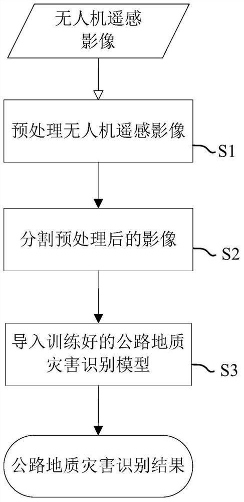
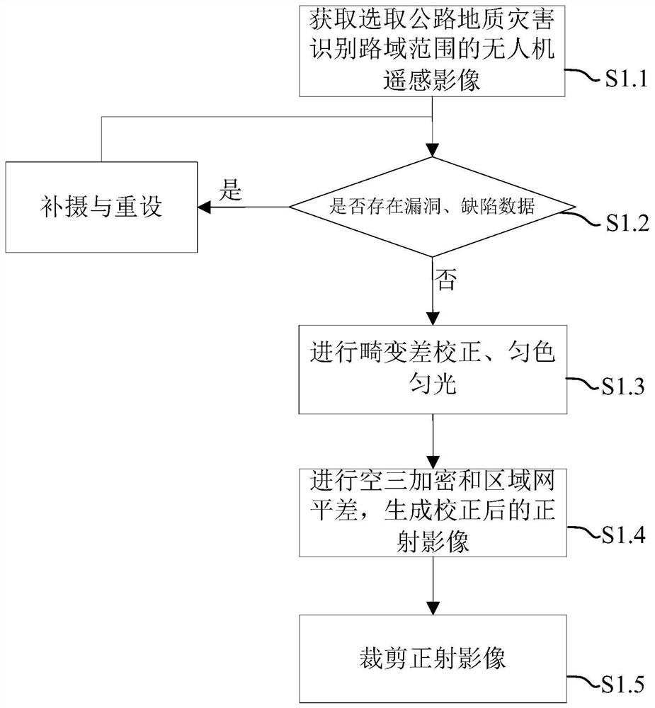
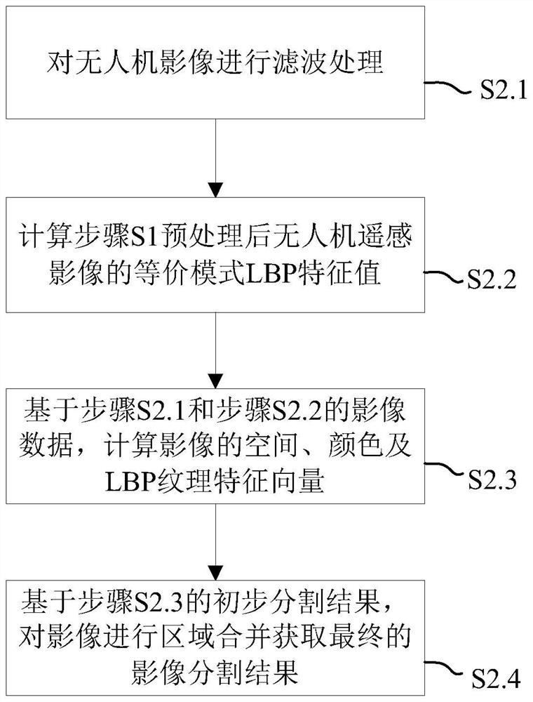
[0050] The present invention will be further described in detail below in conjunction with the accompanying drawings and specific embodiments.

[0051] In recent years, with the rapid development of computer technology, deep learning has been widely used in many fields such as computer vision, speech recognition and natural language processing. Convolutional Neural Networks (CNN, Convolutional Neural Networks) is currently the most studied and most mature model in deep learning. It has been successfully applied in high-resolution remote sensing image classification, feature extraction, and scene recognition. However, CNN model training requires the use of a large number of labeled samples. Only when the number of training samples is large enough and the network structure is relatively complex can it show excellent performance; and in the absence of training samples, the network is prone to overfitting. The combination and fall into the local optimal solution and so on.

[005...


PUM


Abstract

The present invention relates to the technical field of highway geological disaster identification, and discloses a method for identifying highway geological disasters based on pre-trained DCNN, which includes the following steps: step S1, obtaining remote sensing images of drones within the road area of ​​the highway, and pre-training After processing, an absolutely oriented orthophoto image is obtained; step S2, using the mean shift algorithm considering image texture features to segment the preprocessed UAV remote sensing image; step S3, using the segmented UAV remote sensing image data as input data, Apply it to the trained highway geological hazard identification model to obtain the highway geological hazard identification result. The invention adopts the high-resolution image of the UAV, segments the image based on the mean shift algorithm considering texture features, and uses the segmented image unit as the input data of the geological disaster recognition model, which can effectively improve the efficiency of visual interpretation of the existing geological disasters , to provide data support for highway field survey and disaster risk assessment.

Description

technical field [0001] The invention relates to the technical field of highway geological disaster identification, in particular to a method for identifying road geological disasters based on pre-trained DCNN. Background technique [0002] Due to its long belt-like distribution characteristics, highway engineering inevitably needs to cross different types of geomorphic units during construction, involving various complex terrain and geological conditions, and is easily affected by the geological environment along the line. Especially after mountainous roads are washed or infiltrated by rainwater, it is very easy to induce geological disasters such as collapses, landslides, and mud-rock flows. According to statistics, the losses caused by road geological disasters in our country amount to several billion yuan every year, causing huge losses to people's lives and national property. Geological disasters seriously threaten the normal operation of road transportation infrastructu...

Claims


Application Information

Patent Timeline
Patent Type & Authority Patents(China)
IPC IPC(8): G06K9/00G06K9/34G06N3/04
CPCG06V20/182G06V10/267G06N3/045
Inventor 杨晶王丽园罗丰余绍淮罗博仁刘德强徐乔
Owner CCCC SECOND HIGHWAY CONSULTANTS CO LTD
Why Eureka
Try Eureka