Surveying and mapping result directory automatic checking and warehousing release method based on semantic integrity

An automatic inspection and integrity technology, applied in the field of geographic surveying and mapping, can solve problems such as errors in manual inspection, and achieve the effect of improving inspection and publishing efficiency, reducing workload, and saving user costs.

Inactive Publication Date: 2019-07-23
CHONGQING GEOMATICS & REMOTE SENSING CENT
View PDF2 Cites 4 Cited by
  • Summary
  • Abstract
  • Description
  • Claims
  • Application Information

AI Technical Summary

Problems solved by technology

[0004] Aiming at the deficiencies of the prior art, the purpose of the present invention is to provide a method for automatic inspection and warehousing of surveying and mapping results catalogs based on semantic integrity. By supplementing the metadata semantic integrity rule model of surveying and mapping results

Method used


Image

  • Surveying and mapping result directory automatic checking and warehousing release method based on semantic integrity
  • Surveying and mapping result directory automatic checking and warehousing release method based on semantic integrity
  • Surveying and mapping result directory automatic checking and warehousing release method based on semantic integrity

Examples


Embodiment Construction

[0032] The specific implementation manner and working principle of the present invention will be further described in detail below in conjunction with the accompanying drawings.

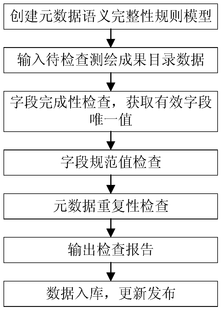
[0033] like figure 1 As shown, a method for automatic inspection and warehousing of surveying and mapping results catalogs based on semantic integrity, the specific steps are as follows:

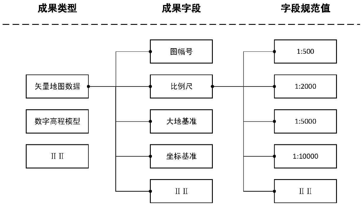
[0034] Step 1: Create a metadata semantic integrity rule model, that is, create a metadata semantic integrity rule model that complies with standard specifications and includes three parts: achievement type, achievement field, and field specification value, such as figure 2 shown;

[0035] Wherein, the type of achievement is a description of the category of surveying and mapping achievements to be checked, which mainly includes vector topographic maps, digital elevation models, framed orthophotos, digital raster maps, simulated topographic maps, triangle points, leveling Points, gravity points, GNSS results, sat...


PUM


Abstract

The invention discloses a surveying and mapping result directory automatic checking and warehousing release method based on semantic integrity. The method comprises the following steps of creating a metadata semantic integrity rule model which comprises an achievement type, an achievement field and a field specification value and conforms to a standard specification; inputting the surveying and mapping result catalog data to be checked, and sequentially carrying out field integrity checking, field normative value checking and metadata repetitive checking to realize the automatic checking of the catalog data, and then outputting a checking report, finally storing the checked surveying and mapping result catalog data into a database, and uniformly updating the database and releasing the result to the outside. The method has the remarkable effects that by establishing the metadata semantic integrity rule model, the metadata of a to-be-detected surveying and mapping result directory is automatically checked and warehoused, and the checking report can be outputted without manual intervention, so that the workload can be greatly reduced, the user cost is saved, the efficiency is improved, the expandability is strong, and the application range is wide.

Description

technical field [0001] The invention relates to the technical field of geographic surveying and mapping, in particular to a method for automatically checking, storing and releasing catalogs of surveying and mapping results based on semantic integrity. Background technique [0002] The catalog of surveying and mapping results is the result of combing and integrating surveying and mapping results resources, which can effectively promote the sharing and application of surveying and mapping results resources. With the continuous development of surveying and mapping production, more and more units are engaged in the production of surveying and mapping results, and the surveying and mapping results have the characteristics of multi-scale, multi-type, and multi-source, which makes it more and more common that the catalog of surveying and mapping results submitted does not meet the standard specifications , such as various types of results, inconsistent attribute information structu...

Claims


Application Information

Patent Timeline
IPC IPC(8): G06F16/29G06F16/21
CPCG06F16/21G06F16/29
Inventor 杨航余静李静贾敦新梁星赵翔宇张泽烈余洋邵帅程宇翔曾诚梁均军李胜欧其健瞿晓雯
Owner CHONGQING GEOMATICS & REMOTE SENSING CENT
Why Eureka
Try Eureka