Geosynchronous spaceborne-airborne bistatic SAR large-width imaging method

A geosynchronous orbit, synthetic aperture radar technology, applied in the direction of reflection/re-radiation of radio waves, utilization of re-radiation, measurement devices, etc., can solve the problems of unambiguous imaging, inability, spectrum aliasing, etc.

Active Publication Date: 2019-08-30
UNIV OF ELECTRONIC SCI & TECH OF CHINA
View PDF11 Cites 8 Cited by
  • Summary
  • Abstract
  • Description
  • Claims
  • Application Information

AI Technical Summary

Problems solved by technology

However, since the point target echo Doppler bandwidth of general GEO-BiSAR has exceeded the pulse repetition frequency (PRF) of the transmitting station, it will cause spectrum aliasing due to undersampling, resulting in undersampling ambiguity. In the prior art, A multi-channel technique for undersampling blur in GEO BiSAR is proposed
However, the echo spectrum received in TOPS mode will have Doppler centroid space variation, and the spectrum of targe

Method used


Image

  • Geosynchronous spaceborne-airborne bistatic SAR large-width imaging method
  • Geosynchronous spaceborne-airborne bistatic SAR large-width imaging method
  • Geosynchronous spaceborne-airborne bistatic SAR large-width imaging method

Examples


Embodiment Construction

[0094] Embodiments of the present invention will be further described below in conjunction with the accompanying drawings.

[0095] The present invention proposes a large-width imaging method for a geosynchronous orbit star-machine dual-base synthetic aperture radar. active remote sensing sensors. The GEO satellite-based bistatic SAR (GEO-BiSAR), that is, the geosynchronous orbit satellite-based bistatic synthetic aperture radar, is a type of bistatic SAR, which uses a geosynchronous orbit satellite as the transmitting station, and the receiving station is an airborne The platform's star machine bistatic SAR.

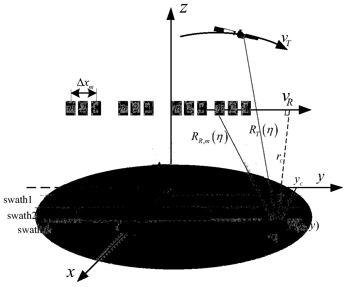
[0096] In this embodiment, the geometric structure of the GEO satellite bistatic SAR is as follows figure 1 The system parameters are shown in Table 1 below.

[0097] Table 1. Parameters of the GEO satellite bistatic SAR system

[0098]

[0099]

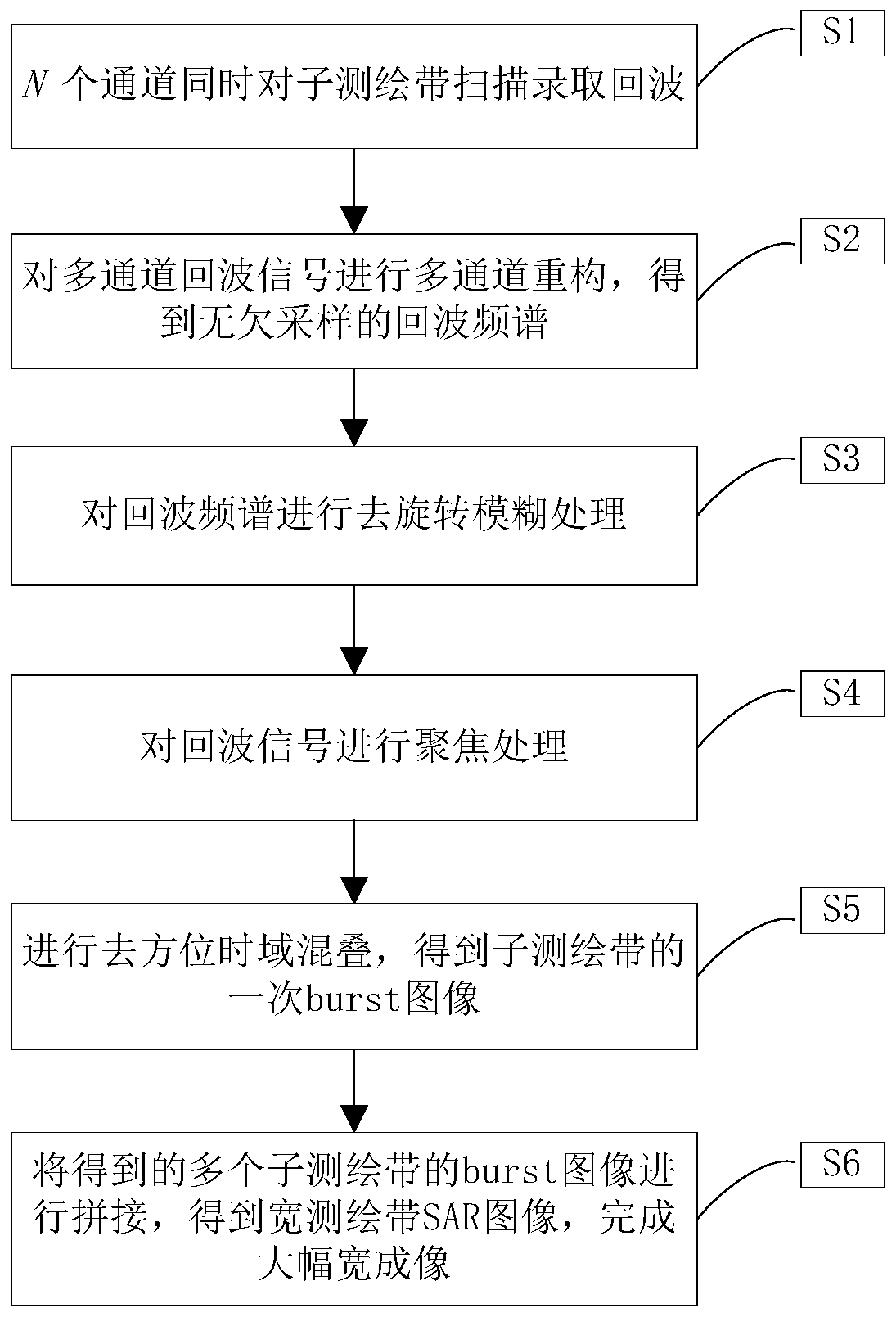
[0100] see figure 2 , the present invention is realized through the following steps:

[0101] S1, N channels re...


PUM


Abstract

The invention provides a geosynchronous spaceborne-airborne bistatic SAR large-width imaging method, and belongs to the technical field of SAR. According to the method, TOPS scanning is firstly carried out on a plurality of channels to admit echoes, the received multi-channel echoes are processed, undersampling fuzziness is removed, rotation fuzziness is solved, and splicing is carried out to obtain a large-width imaging result. Aiming at the large-range coverage of a GEO irradiation source for the ground, a TOPS mode is adopted at an airborne receiving station to carry out scanning on a plurality of swaths so as to admit echoes, the irradiation range of a transmitting station is sufficiently utilized, and the imaging width of GEO spaceborne-airborne bistatic SAR is enlarged. The method ischaracterized in that when the monostatic TOPS echoes in the bistatic configurations are processed, a multichannel reconstruction technology and a TOPS processing method are combined to solve the udnersampling fuzziness and rotation fuzziness in the SAR echo frequency spectrums.

Description

technical field [0001] The invention belongs to the technical field of synthetic aperture radar, and in particular relates to a large-width imaging method of a geosynchronous orbit star-machine bistatic synthetic aperture radar. Background technique [0002] Synthetic Aperture Radar (SAR) is a high-resolution imaging radar with strong penetrability and all-weather and all-weather characteristics. At present, the technology is relatively mature and is widely used in the fields of earth remote sensing, resource exploration, topographic mapping, etc. . [0003] Geosynchronous Synthetic Aperture Radar (GEOSAR) has a synchronous orbit with an orbital height of about 36,000km, and its beam can cover the ground up to 280km. It has the advantages of short revisit period and wide observable range. Maintain continuous irradiation of the designated area within the range. [0004] Geosynchronous Spaceborne-Airborne Bistatic SAR (GEO BiSAR) uses the GEO SAR satellite as the illuminatio...

Claims


Application Information

Patent Timeline
IPC IPC(8): G01S13/90
CPCG01S13/90G01S13/9011G01S13/9058
Inventor 李中余何旬武俊杰安洪阳张强辉杨建宇
Owner UNIV OF ELECTRONIC SCI & TECH OF CHINA
Why Eureka
Try Eureka