A road planning and navigation system that can automatically generate survey maps

A navigation system and automatic generation technology, applied in image data processing, instruments, calculations, etc., can solve problems such as inconvenient management and maintenance work, inaccurate integration, and on-site situation errors, so as to increase three-dimensional images, reduce position errors, and improve accuracy. sexual effect

Active Publication Date: 2020-08-14
GUANGDONG POWER GRID CO LTD +1
View PDF8 Cites 0 Cited by
  • Summary
  • Abstract
  • Description
  • Claims
  • Application Information

AI Technical Summary

Problems solved by technology

[0004] However, the current navigation system only has the traditional mobile guidance function, and when it is applied to road survey work, there are still the following defects:
[0005] (1) Ordinary GPS navigation systems can only provide two-dimensional plane guidance, so the survey results of buildings next to the road cannot be accurately integrated into the navigation system, which is inconvenient for later management and maintenance work;
[0006] (2) Drawings are mostly used to record survey results, which are easy to lose and difficult to save, and it is not easy for management and maintenance personnel to determine the corresponding location in time, there are errors with the site conditions, and the workload of drawing pictures is heavy, which increases the difficulty of data processing;
[0007] (3) Most of the two-dimensional plans of survey roads and survey objects are manually drawn, so the degree of influence on survey objects cannot be intuitively recognized, and the drawing can only be used by professionals in this technical field

Method used


Image

  • A road planning and navigation system that can automatically generate survey maps

Examples


Embodiment Construction

[0043]In order to enable those skilled in the art to better understand the solution of the present invention, the present invention will be further described in detail below in conjunction with the accompanying drawings and specific embodiments. Apparently, the described embodiments are only some of the embodiments of the present invention, but not all of them. Based on the embodiments of the present invention, all other embodiments obtained by persons of ordinary skill in the art without making creative efforts belong to the protection scope of the present invention.

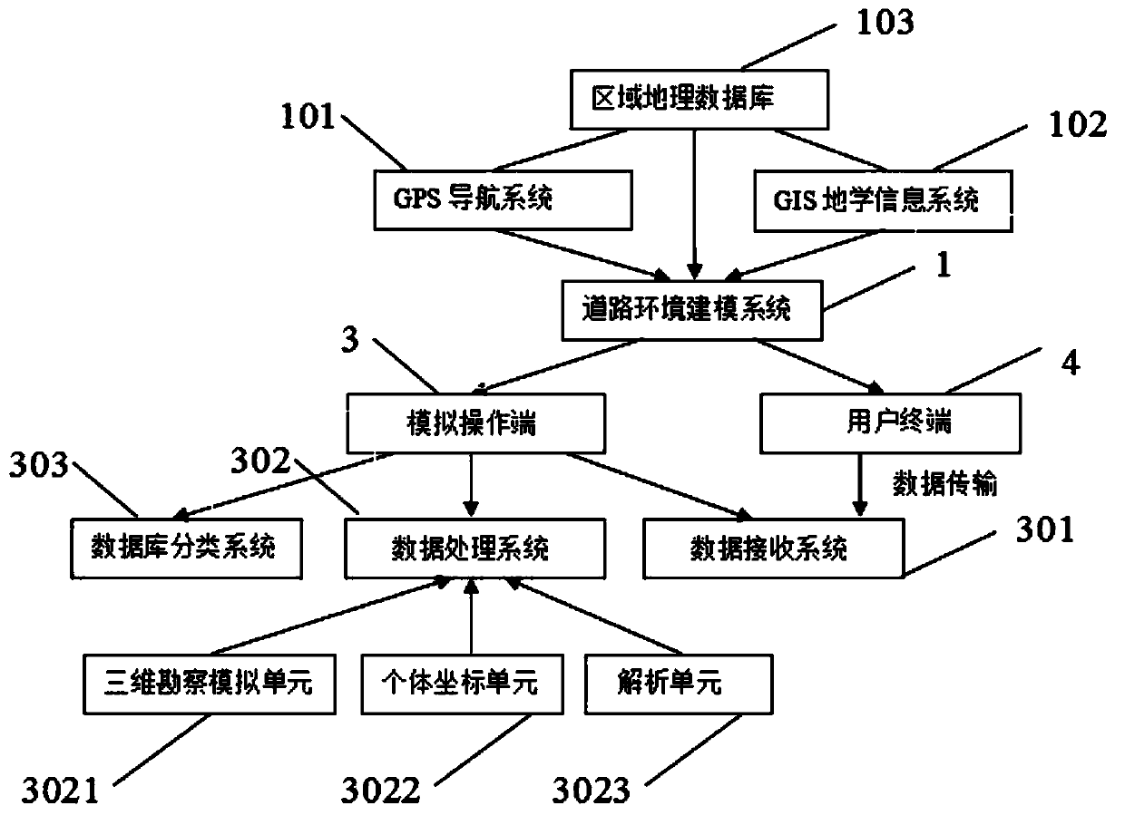
[0044] Such as figure 1 As shown, the present invention provides a road planning and navigation system that can automatically generate survey maps. After the navigation system selects the starting point and the end point, for the user, the navigation system can not only provide the user with multiple survey routes, but also It can also mark the user's current position coordinates or the coordinates of the sele...


PUM


Abstract

The embodiment of the invention discloses a road planning navigation system capable of automatically generating an investigation map. The system comprises a road environment modeling system, a simulation operation end and a user terminal. The user terminal uses a navigation system in the road environment modeling system to select an investigation route. The simulation operation end performs secondary editing and storage processing on the road environment modeling system according to the survey information. The road environment modeling system comprises a regional geographic database, a GPS navigation system and a GIS geo-science information system. The GIS geo-science information system and the GPS navigation system enable geographic distribution information in the regional geographic database to generate a three-dimensional map, and the GPS navigation system can display the three-dimensional geographic information in a two-dimensional mode. According to the scheme, the survey information is edited and built again in the GIS geology information system, the two-dimensional graph or the three-dimensional graph about the survey information is generated, and therefore manual drawing again is not needed, and errors caused by manual drawing of a survey route are reduced.

Description

technical field [0001] The invention relates to the technical field of planning and surveying, in particular to a road planning and navigation system capable of automatically generating survey maps. Background technique [0002] Improving the level of road traffic safety is a major event that benefits the country and the people, and many experts and scholars have conducted extensive and in-depth research in this area. Prevention of traffic accidents is one of the main tasks of traffic safety, and it is also an important content of traffic engineering research. The significance of traffic safety is not only related to one's own life and safety, but also a manifestation of respecting the lives of others, and is an important factor in building a harmonious society . Some people once called traffic accidents "traffic wars in modern society". Traffic accidents are like invisible killers, lurking on the road and waiting for violators to appear. Therefore, people should learn to ...

Claims


Application Information

Patent Timeline
Patent Type & Authority Patents(China)
IPC IPC(8): G06F16/29G06T17/05G06T19/00
CPCG06F16/29G06T17/05G06T19/003
Inventor 李家淇
Owner GUANGDONG POWER GRID CO LTD
Why Eureka
Try Eureka