

Land utilization/coverage classification method for water and soil loss monitoring in northern earth-rock mountainous area
A classification method and technology for soil and rocky mountainous areas, applied in the field of land use/cover classification for soil erosion monitoring in northern soil-rocky mountainous areas, can solve problems such as excessive division of land types, influence of calculation results, failure to timely reflect new changes in land use, etc., and achieve clear images. The effect of texture information and rich spatial information
Pending Publication Date: 2019-09-06
NANJING FORESTRY UNIV
View PDF2 Cites 12 Cited by
- Summary
- Abstract
- Description
- Claims
- Application Information
AI Technical Summary
Problems solved by technology
Practical application proves that the existing classification of land use status cannot meet the needs of soil erosion monitoring
[0005] (2) The existing classification levels of land use status are difficult to meet the requirements of data source accuracy and soil erosion evaluation
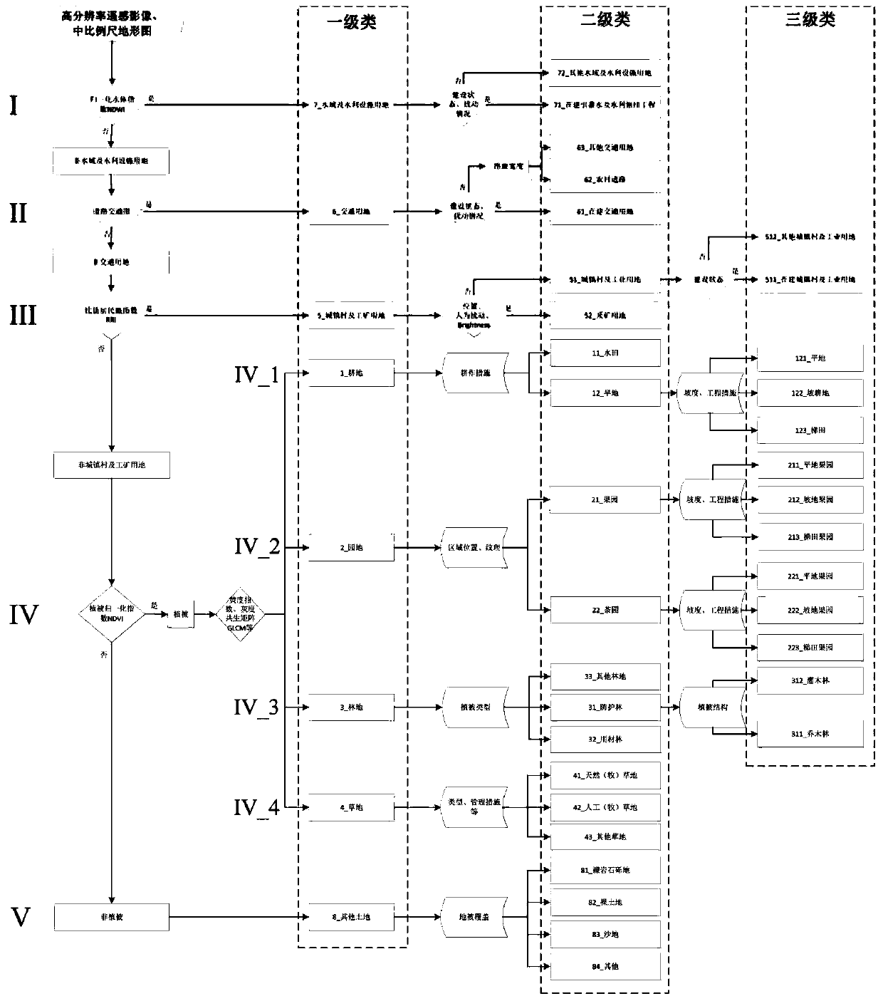
The current land use status classification system does not further subdivide it. For example, dry land/orchard/tea garden include flat land, slope land, and terraced fields. The above three subcategories have obvious differences in their terrain, slope characteristics, and engineering measures. The combination of its three subcategories cannot accurately and effectively evaluate the state of soil erosion
Whether human activities disturb the surface or not, that is, under constructi
Method used
View moreImage
Smart ImageViewing Examples

Examples
 PUM
 Abstract
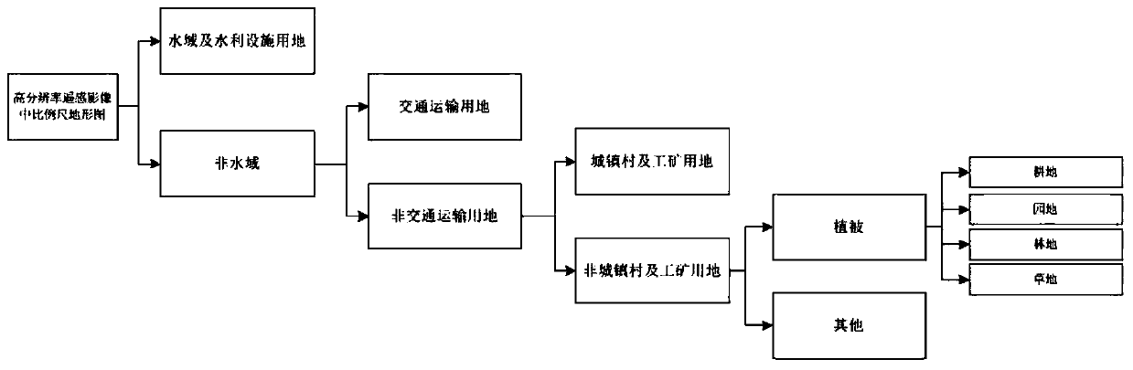
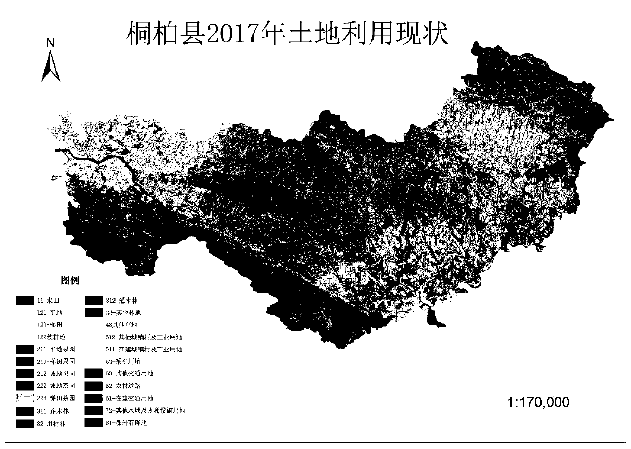
The invention discloses a land utilization/coverage classification method for water and soil loss monitoring in northern soil and stone mountainous areas. The method is based on a high-resolution remote sensing image and medium-scale topographic map data. A layered division extraction method is adopted; layer-by-layer control, layer by layer refinement, a quantitative and qualitative combined method are adopted to carry out three-level classification on land utilization/coverage; the first class is subjected to combining, calculating and quantitatively dividing through wave band spectrums of high-resolution remote sensing images, the second class and the third class are distinguished by adopting a qualitative classification method which comprises steps of firstly dividing water areas and water conservancy facilities, secondly dividing traffic transportation lands, thirdly dividing town lands and industrial and mining lands, and finally dividing ploughing lands, garden lands, forest lands, grasslands and other lands. The method has outstanding professional characteristics, meets the water and soil loss monitoring requirements, is clear in land utilization classification and layeringand comprehensive in content, improves the soil erosion calculation result quality, effectively evaluates the result precision, and is very necessary for researching and promoting the development ofbasic units for water and soil loss dynamic monitoring.
Description
technical field [0001] The invention belongs to the technical field of water and soil loss monitoring, and in particular relates to a land use / coverage classification method for monitoring water and soil loss in northern rocky mountainous areas based on high-resolution remote sensing images and medium-scale topographic map data. Background technique [0002] Land use classification is a comprehensive classification based on the natural and economic attributes of land and its factors. Specifically, the classification is based on the land cover characteristics, management purposes and use methods as the main basis and symbol. It reflects the development of a period of time. The actual situation of land use. The land use type refers to the unit of land with the same land use, and the unit of land with basically the same covering characteristics, management purposes and use methods is usually classified as a land use type; land cover refers to the natural or human-induced coveri...
Claims
Login to View More Application Information
Patent Timeline
 IPC IPC(8): G06K9/00G06K9/20G06Q50/26
CPCG06Q50/26G06V20/13G06V10/143
Inventor刘霞张洪达齐斐李欢吴迪袁利张荣华牛勇
OwnerNANJING FORESTRY UNIV