Space-time accompanying object mining method based on Geohash

An object, space-time technology, applied in special data processing applications, instruments, electrical digital data processing, etc., to achieve the effect of ensuring accuracy

Inactive Publication Date: 2019-10-15
NANJING UNIV OF POSTS & TELECOMM
View PDF4 Cites 11 Cited by
  • Summary
  • Abstract
  • Description
  • Claims
  • Application Information

AI Technical Summary

Problems solved by technology

[0004] Purpose of the invention: In order to improve the time efficiency and accuracy of spatiotemporal companion object mining, t...

Method used


Image

  • Space-time accompanying object mining method based on Geohash
  • Space-time accompanying object mining method based on Geohash
  • Space-time accompanying object mining method based on Geohash

Examples


Embodiment Construction

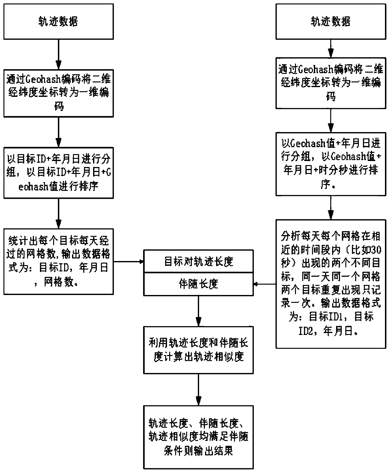
[0031] The present invention will be further described in detail below in conjunction with the drawings. Such as figure 1 As shown, the present invention includes the following steps:

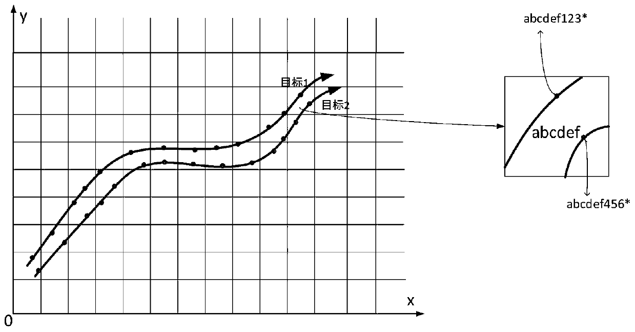
[0032] figure 2 This is a schematic diagram of the present invention using Geohash coding to grid the map. The Geohash code prefixes of track points in the same grid are the same. Such as figure 2 In the grid represented by "abcdef", the first 6 digits of target 1 and target 2 track points "abcdef123*" and "abcdef456*" are the same.

[0033] 1. The trajectory length calculation stage includes the following steps:

[0034] (1) Input the trajectory data "target ID, year, month, day, hour, minute, second, longitude, latitude", and convert the latitude and longitude of each data to a fixed precision Geohash value. The output data format is: target ID, year, month, day, hour and minute Second, the Geohash value; the fixed accuracy of the Geohash value is the key factor. If the length of the Geohash ...


PUM


Abstract

The invention provides a space-time accompanying object mining method based on Geohash, and the method comprises the steps: firstly converting the longitude and latitude of each piece of track data into Geohash codes, storing the Geohash codes in a database, and achieving the gridding coding of a map; secondly, counting the number of grids passed by each track object and the number of grids whereevery two objects appear at the same time at the similar time through a Geohash value; and finally, calculating the track similarity of the moving object so as to mine the accompanying object. By adopting the method and the device, the space-time accompanying object mining efficiency can be remarkably improved under the condition of ensuring relatively high accuracy.

Description

Technical field [0001] The invention belongs to the field of mobile object databases, and relates to an efficient spatiotemporal companion object mining method, in particular to a Geohash-based spatiotemporal companion object mining method. Background technique [0002] With the rapid development of wireless communication and mobile computing technology, as well as global positioning and navigation systems, space trajectory data continues to increase. Excavating spatiotemporal companion objects through these trajectories from humans, animals, vehicles and ships can play a role in animal research, urban road planning, and military monitoring. [0003] The current methods for mining spatio-temporal companion objects have certain defects in time efficiency and accuracy. For example, the DBSCAN algorithm in trajectory clustering has high time complexity, which is not conducive to the mining of accompanying objects of trajectory data in a big data environment. At the same time, most m...

Claims


Application Information

Patent Timeline
IPC IPC(8): G06F16/29G06F16/2458
CPCG06F16/2465G06F16/29
Inventor 戴华李佳玮杨庚徐佳黄海平
Owner NANJING UNIV OF POSTS & TELECOMM
Why Eureka
Try Eureka