A Mesoscale Convective System Identification and Tracking Method Based on Geostationary Satellite Infrared Cloud Images

A mesoscale convective and geostationary satellite technology, used in scene recognition, character and pattern recognition, image analysis, etc. Applicability and Accuracy, Effects for Identifying and Tracking Accuracy

Active Publication Date: 2021-08-06
NAT UNIV OF DEFENSE TECH
View PDF8 Cites 0 Cited by
  • Summary
  • Abstract
  • Description
  • Claims
  • Application Information

AI Technical Summary

Problems solved by technology

Because the evolution process of mesoscale convective systems is very complex, the cloud top profile cannot fully represent the system change process, for example, the division or fusion of the system usually leads to the wrong tracking of the system

Method used


Image

  • A Mesoscale Convective System Identification and Tracking Method Based on Geostationary Satellite Infrared Cloud Images
  • A Mesoscale Convective System Identification and Tracking Method Based on Geostationary Satellite Infrared Cloud Images
  • A Mesoscale Convective System Identification and Tracking Method Based on Geostationary Satellite Infrared Cloud Images

Examples


Embodiment Construction

[0058] In order to better understand the technical content of the present invention, specific embodiments are given together with the attached drawings for description as follows.

[0059] Aspects of the invention are described in this disclosure with reference to the accompanying drawings, which show a number of illustrated embodiments. Embodiments of the present disclosure are not necessarily intended to include all aspects of the invention. It should be appreciated that the various concepts and embodiments described above, as well as those described in more detail below, can be implemented in any of numerous ways, since the concepts and embodiments disclosed herein are not limited to any implementation. In addition, some aspects of the present disclosure may be used alone or in any suitable combination with other aspects of the present disclosure.

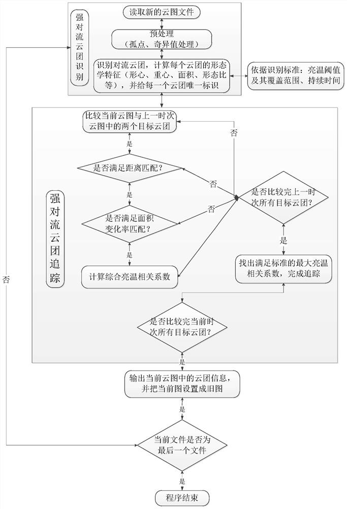
[0060] The present invention provides a mesoscale convective system identification and tracking method based on static satel...


PUM


Abstract

The invention provides a method for identifying and tracking a mesoscale convective system based on a stationary satellite infrared cloud image, which is characterized in that it comprises the following steps: 1) marking the boundary of the mesoscale convective system on the stationary satellite cloud image; 2) the area surrounded by the closed boundary Fill and number; 3) Repeat steps 1) and 2) until all mesoscale convective systems are marked; 4) Calculate the cloud properties of each numbered mesoscale convective system; 5) Use two consecutive frames of cloud images , determine the candidate cloud cluster of the mesoscale convective system to be tracked at the next moment; 6) calculate the spatial correlation coefficient between the mesoscale convective system to be tracked and the candidate cloud cluster; 7) complete the tracking of the mesoscale convective system by comparing the spatial correlation coefficient . The invention can automatically complete the identification and tracking process of the mesoscale convection system, and significantly improves the calculation efficiency and accuracy.

Description

technical field [0001] The invention belongs to the technical field of weather forecasting, and in particular relates to a method for identifying and tracking a mesoscale convective system based on a static satellite infrared cloud image. Background technique [0002] The mesoscale convective system MCS (Mesoscale Convective System) is the main weather system that causes disastrous weather. Accurate detection and forecasting of it is an important prerequisite for disaster prevention and mitigation. Mesoscale convective systems are difficult to be captured by conventional surface meteorological observation networks due to their small scale and short life history, resulting in a lack of understanding of their occurrence and development process. With the rapid development of meteorological satellite technology, it is possible to identify and track mesoscale convective systems. [0003] In the identification of mesoscale convective systems, threshold discrimination of infrared ...

Claims


Application Information

Patent Timeline
Patent Type & Authority Patents(China)
IPC IPC(8): G06K9/00G06T7/246G06T7/62
CPCG06T7/246G06T7/62G06T2207/10032G06T2207/30192G06V20/13
Inventor 黄小刚阳向荣费建芳程小平丁菊丽
Owner NAT UNIV OF DEFENSE TECH
Why Eureka
Try Eureka