A monitoring and early warning method for illegal parking of taxis based on trajectory and map data
A trajectory data and map data technology, applied in the field of traffic safety, can solve the problems of illegal parking of taxis, less overall analysis of GPS trajectory data, etc., to achieve the effect of expanding direction and ensuring traffic safety
- Summary
- Abstract
- Description
- Claims
- Application Information
AI Technical Summary
Problems solved by technology
Method used
Image

Examples
Embodiment 1
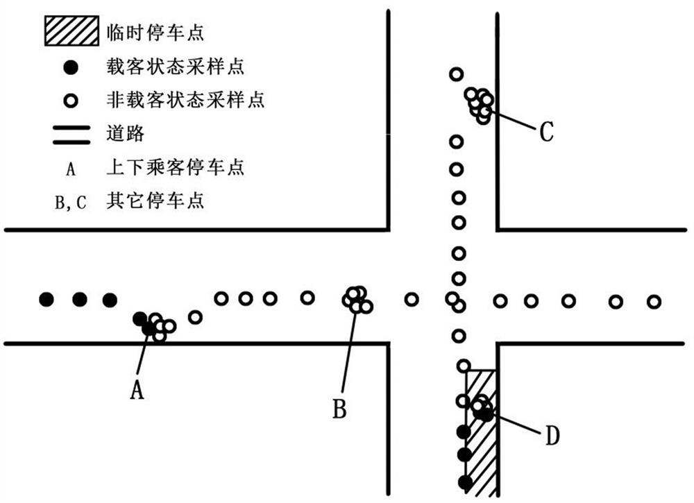
[0027] Such as figure 1 Shown, the realization process of the present invention is a kind of taxi illegal parking monitoring and early warning method based on GPS track data and map data, comprises steps:
[0028] A. Data processing: clean and reconstruct the original Beidou or GPS positioning data of vehicle A, and remove abnormal data and redundant data;
[0029] B. Matching of trajectory data and digital map; quickly match the Beidou or GPS data of the vehicle processed in step A to the digital map, associate the vehicle trajectory data with the digital map, and determine the road section to which the vehicle belongs. Take a sample every 2 seconds;
[0030] C. Judgment of parking point clusters: a certain period of time T 1 In , the vehicle’s sampling speed is 0 for 6 consecutive times, and the center of the parking point cluster is obtained by the K-means clustering algorithm at A, and the passenger status value is G 1 Change, the direction of the trajectory line change...
Embodiment 2
[0036] Such as figure 1 Shown, the realization process of the present invention is a kind of taxi illegal parking monitoring and early warning method based on GPS track data and map data, comprises steps:
[0037] A. Data processing: clean and reconstruct the original Beidou or GPS positioning data of vehicle B, and remove abnormal data and redundant data;
[0038] B. Matching of trajectory data and digital map; quickly match the Beidou or GPS data of the vehicle processed in step A to the digital map, associate the vehicle trajectory data with the digital map, and determine the road section to which the vehicle belongs. Sampling is performed once in 1 second;
[0039] C. Judgment of parking point clusters: a certain period of time T 1 , the vehicle’s 8 consecutive sampling speeds are 0, and the center of the parking point cluster is located at C through the K-means clustering algorithm. The distance from the sideline of the road is H=0.5 meters;
[0040] D. Interpretation...
Embodiment 3
[0045] like figure 1 Shown, the realization process of the present invention is a kind of taxi illegal parking monitoring and early warning method based on GPS track data and map data, comprises steps:
[0046] A. Data processing: clean and reconstruct the original Beidou or GPS positioning data of vehicle B, and remove abnormal data and redundant data;
[0047] B. Matching of trajectory data and digital map; quickly match the Beidou or GPS data of the vehicle processed in step A to the digital map, associate the vehicle trajectory data with the digital map, and determine the road section to which the vehicle belongs. Sampling is performed once in 1 second;
[0048] C. Judgment of parking point clusters: a certain period of time T 1 In this case, the vehicle’s sampling speed is 0 for 5 consecutive times, and the center of the parking point cluster is located at D through the K-means clustering algorithm. The sideline distance H=0.8 meters;
[0049] D. Interpretation of pas...
PUM
 Abstract
Description
Claims
Application Information
 - R&D
- Intellectual Property
- Life Sciences
- Materials
- Tech Scout
- Unparalleled Data Quality
- Higher Quality Content
- 60% Fewer Hallucinations
Browse by: Latest US Patents, China's latest patents, Technical Efficacy Thesaurus, Application Domain, Technology Topic, Popular Technical Reports.
© 2025 PatSnap. All rights reserved.Legal|Privacy policy|Modern Slavery Act Transparency Statement|Sitemap|About US| Contact US: help@patsnap.com